Map of Greene County - Greene County is a county located in the U.S. state of Missouri. Greene County Map showing cities, highways, important places and water bodies. Get Where is Greene County located in the map, major cities in Greene county, population, areas, and places of interest.
Map of Greene County, Missouri
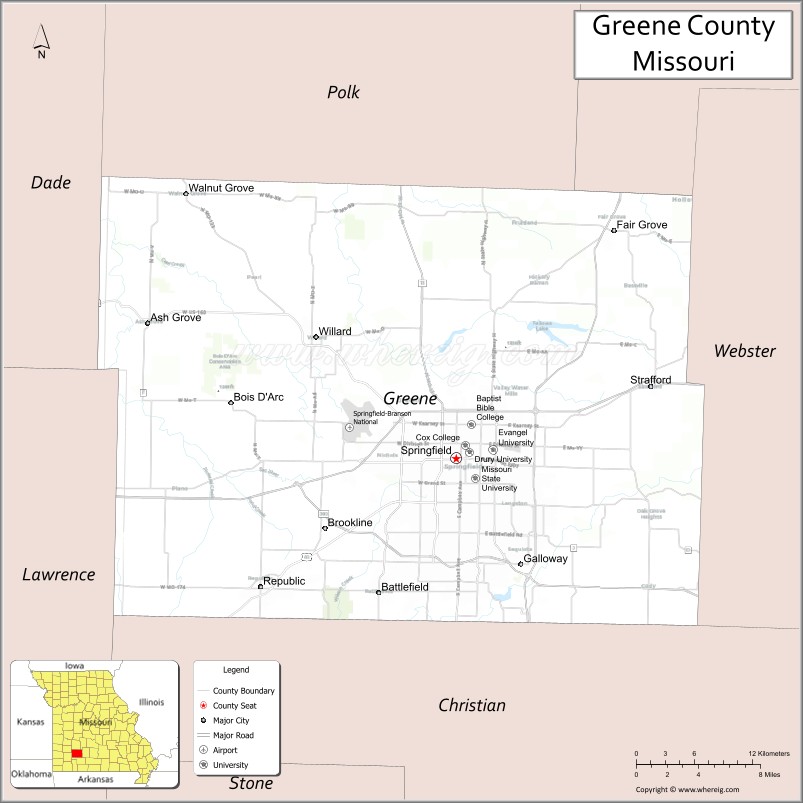
About Greene County Map, Missouri: The map showing the county boundary, county seat, major cities, highways, water bodies and neighbouring counties.
Related Missouri Maps & Info
Greene County, Missouri
Greene County is a county located in the U.S. state of Missouri. It's county seat is Springfield. As per 2020 census, the population of Greene County is 300865 people and population density is square miles. According to the United States Census Bureau, the county has a total area of 675 sq mi (1,748 km2). Greene County was established on 1833.
Greene County Facts
| Continent | North America |
| Country | United States |
| State | Missouri |
| County Seat | Springfield |
| Largest City/Town | Springfield |
| Established | 1833 |
| Total Area | 678 sq mi (1,756 sq km) |
| Land Area | 675 sq mi (1,748 sq km) |
| Water Area | 3 sq mi (8 sq km) |
| Population | 298,915 (Census 2020) |
| Population Density | 442.8 people per sq mi |
| Time Zone | Central Time Zone (CST/CDT) |
| Major Highways | Interstate 44, U.S. Route 60, U.S. Route 65, U.S. Route 160, U.S. Route 66 Historic Route |
| Major Rivers | James River, Sac River |
| Neighboring Counties | Polk County, Dallas County, Webster County, Christian County, Lawrence County |
| Famous For | Springfield city, Route 66 history, universities, healthcare, and Ozark culture |
| Top Attractions | Fantastic Caverns, Wonders of Wildlife Museum, Bass Pro Shops, and Nathanael Greene Park |
| Official Website | Official Website |
About Greene County
Greene County is located in southwestern Missouri in the Ozarks region and was established in 1833. The county seat and largest city is Springfield, which is the third-largest city in Missouri. The county is known for education, healthcare, Route 66 heritage, entertainment, outdoor recreation, and being a major commercial center of southwest Missouri.
Cities and Towns in Greene County, Missouri
| City/Town | Population (Census 2020) | Latitude & Longitude |
|---|---|---|
| Springfield (county seat) | 169,176 | 37.2089°N, 93.2923°W |
| Republic | 18,750 | 37.1209°N, 93.4802°W |
| Willard | 6,344 | 37.3053°N, 93.4271°W |
| Strafford | 2,543 | 37.2681°N, 93.1171°W |
| Battlefield | 6,068 | 37.1159°N, 93.3705°W |
| Walnut Grove | 657 | 37.4123°N, 93.5488°W |
What are the Golf Courses in Greene County
| Golf Course | Location | Latitude & Longitude |
|---|---|---|
| Highland Springs Country Club | Springfield | 37.1450°N, 93.2447°W |
| Rivercut Golf Course | Springfield | 37.1084°N, 93.3246°W |
| Horton Smith Golf Course | Springfield | 37.2318°N, 93.3197°W |
Major Roads and Highways in Greene County
Major highways make Greene County one of the most important transportation hubs in southwest Missouri.
- Interstate 44 - major interstate connecting Springfield with St. Louis and Oklahoma
- U.S. Route 60 - east-west highway serving southern Missouri
- U.S. Route 65 - north-south corridor through central Missouri and the Ozarks
- U.S. Route 160 - regional highway linking communities across southwest Missouri
- Historic Route 66 - famous historic roadway passing through Springfield
What are Neighboring Counties of Greene County
- Polk County (north)
- Dallas County (northeast)
- Webster County (east)
- Christian County (south)
- Lawrence County (west)
What Are the Top Attractions in Greene County
The county offers major entertainment venues, outdoor recreation, museums, and Route 66 attractions.
- Fantastic Caverns - ride-through cave tours and geological attractions
- Wonders of Wildlife National Museum and Aquarium - large wildlife museum and aquarium complex
- Bass Pro Shops Outdoor World - flagship outdoor recreation retail destination
- Nathanael Greene/Close Memorial Park - botanical gardens, walking trails, and recreation facilities
- Springfield Conservation Nature Center - hiking trails and wildlife education programs
- Route 66 Historic District - classic roadside attractions and historic landmarks
- Dickerson Park Zoo - animal exhibits and family-friendly attractions
- Wilson’s Creek National Battlefield nearby region - Civil War history and scenic landscapes
- Jordan Valley Park - sports facilities, ice rink, and downtown entertainment
- Ozark Greenways Trail System - biking, jogging, and outdoor recreation trails
What Is the Distance from Greene County to Nearby Cities
The following distances are measured by road (driving).
- Springfield to Branson (Taney County), Missouri - 43 mi (69 km)
- Springfield to Joplin (Jasper County), Missouri - 71 mi (114 km)
- Springfield to Jefferson City (Cole County), Missouri - 168 mi (270 km)
- Springfield to Kansas City (Jackson County), Missouri - 166 mi (267 km)
- Springfield to St. Louis (St. Louis City), Missouri - 215 mi (346 km)
- Springfield to Republic (Greene County), Missouri - 13 mi (21 km)
- Springfield to Willard (Greene County), Missouri - 11 mi (18 km)
- Springfield to Tulsa (Tulsa County), Oklahoma - 180 mi (290 km)
- Springfield to Little Rock (Pulaski County), Arkansas - 215 mi (346 km)
- Springfield to Memphis (Shelby County), Tennessee - 295 mi (475 km)
- Springfield to Chicago (Cook County), Illinois - 522 mi (840 km)
- Springfield to Denver (Denver County), Colorado - 637 mi (1,025 km)
- Springfield to Dallas (Dallas County), Texas - 430 mi (692 km)
FAQs about Greene County
Greene County is located in southwestern Missouri in the Ozarks region.
Greene County had a population of 298,915 according to the 2020 United States Census.
Greene County is known for Springfield, Route 66 history, universities, healthcare, and Ozark culture.
The county is served by Interstate 44, U.S. Route 60, U.S. Route 65, U.S. Route 160, and Historic Route 66.
Yes, Greene County includes golf facilities such as Highland Springs Country Club, Rivercut Golf Course, and Horton Smith Golf Course.
References
- QuickFacts - U.S. Census Bureau
- United States Census Bureau
- United States Geological Survey (USGS)
- National Geodetic Survey
- Official Website
- Adair County Map
- Andrew County Map
- Atchison County Map
- Audrain County Map
- Barry County Map
- Barton County Map
- Bates County Map
- Benton County Map
- Bollinger County Map
- Boone County Map
- Buchanan County Map
- Butler County Map
- Caldwell County Map
- Callaway County Map
- Camden County Map
- Cape Girardeau County Map
- Carroll County Map
- Carter County Map
- Cass County Map
- Cedar County Map
- Chariton County Map
- Christian County Map
- Clark County Map
- Clay County Map
- Clinton County Map
- Cole County Map
- Cooper County Map
- Crawford County Map
- Dade County Map
- Dallas County Map
- Daviess County Map
- DeKalb County Map
- Dent County Map
- Douglas County Map
- Dunklin County Map
- Franklin County Map
- Gasconade County Map
- Gentry County Map
- Greene County Map
- Grundy County Map
- Harrison County Map
- Henry County Map
- Hickory County Map
- Holt County Map
- Howard County Map
- Howell County Map
- Iron County Map
- Jackson County Map
- Jasper County Map
- Jefferson County Map
- Johnson County Map
- Knox County Map
- Laclede County Map
- Lafayette County Map
- Lawrence County Map
- Lewis County Map
- Lincoln County Map
- Linn County Map
- Livingston County Map
- McDonald County Map
- Macon County Map
- Madison County Map
- Maries County Map
- Marion County Map
- Mercer County Map
- Miller County Map
- Mississippi County Map
- Moniteau County Map
- Monroe County Map
- Montgomery County Map
- Morgan County Map
- New Madrid County Map
- Newton County Map
- Nodaway County Map
- Oregon County Map
- Osage County Map
- Ozark County Map
- Pemiscot County Map
- Perry County Map
- Pettis County Map
- Phelps County Map
- Pike County Map
- Platte County Map
- Polk County Map
- Pulaski County Map
- Putnam County Map
- Ralls County Map
- Randolph County Map
- Ray County Map
- Reynolds County Map
- Ripley County Map
- St Charles County Map
- St Clair County Map
- Ste Genevieve County Map
- St Francois County Map
- St Louis County Map
- Saline County Map
- Schuyler County Map
- Scotland County Map
- Scott County Map
- Shannon County Map
- Shelby County Map
- Stoddard County Map
- Stone County Map
- Sullivan County Map
- Taney County Map
- Texas County Map
- Vernon County Map
- Warren County Map
- Washington County Map
- Wayne County Map
- Webster County Map
- Worth County Map
- Wright County Map
- St Louis County Map
- Alabama Counties
- Alaska boroughs
- Arizona Counties
- Arkansas Counties
- California County Map
- Colorado Counties
- Connecticut Counties
- Delaware Counties
- Florida County Map
- Georgia County Map
- Hawaii Counties
- Idaho Counties
- Illinois Counties
- Indiana Counties
- Iowa Counties
- Kansas Counties
- Kentucky Counties
- Louisiana Counties
- Maine Counties
- Maryland Counties
- Massachusetts Counties
- Michigan County Map
- Minnesota Counties
- Mississippi Counties
- Missouri Counties
- Montana Counties
- Nebraska Counties
- Nevada Counties
- New York Counties
- New Hampshire Counties
- New Jersey Counties
- New Mexico Counties
- North Carolina Counties
- North Dakota Counties
- Ohio County Map
- Oklahoma Counties
- Oregon Counties
- Pennsylvania Counties
- Rhode Island Counties
- South Carolina Counties
- South Dakota Counties
- Map of Tennessee
- Texas County Map
- Utah Counties
- Vermont Counties
- Virginia Counties
- Washington Counties
- West Virginia Counties
- Wisconsin Counties
- Wyoming Counties