Map of Dunklin County - Dunklin County is a county located in the U.S. state of Missouri. Dunklin County Map showing cities, highways, important places and water bodies. Get Where is Dunklin County located in the map, major cities in Dunklin county, population, areas, and places of interest.
Map of Dunklin County, Missouri
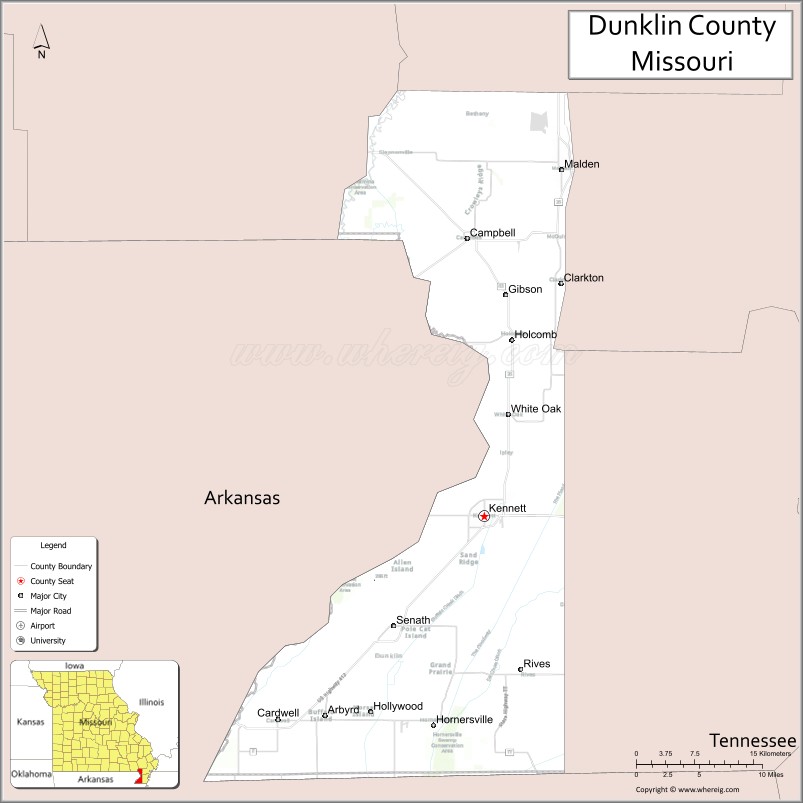
About Dunklin County Map, Missouri: The map showing the county boundary, county seat, major cities, highways, water bodies and neighbouring counties.
Related Missouri Maps & Info
Dunklin County, Missouri
Dunklin County is a county located in the U.S. state of Missouri. It's county seat is Kennett. As per 2020 census, the population of Dunklin County is 27717 people and population density is square miles. According to the United States Census Bureau, the county has a total area of 546 sq mi (1,414 km2). Dunklin County was established on 1843.
Dunklin County Facts
| Continent | North America |
| Country | United States |
| State | Missouri |
| County Seat | Kennett |
| Largest City/Town | Kennett |
| Established | 1845 |
| Total Area | 547 sq mi (1,417 sq km) |
| Land Area | 541 sq mi (1,401 sq km) |
| Water Area | 6 sq mi (16 sq km) |
| Population | 28,561 (Census 2020) |
| Population Density | 52.8 people per sq mi |
| Time Zone | Central Time Zone (CST/CDT) |
| Major Highways | U.S. Route 412, U.S. Route 62, Missouri Route 25, Missouri Route 53 |
| Major Rivers | St. Francis River, Little River drainage system |
| Neighboring Counties | Pemiscot County, New Madrid County, Stoddard County, Butler County |
| Famous For | Agriculture, cotton production, Missouri Bootheel culture, and blues music heritage |
| Top Attractions | Kennett historical district, Hunter-Dawson State Historic Site nearby region, Bootheel countryside, and local music heritage sites |
| Official Website | Official Website |
About Dunklin County
Dunklin County is located in southeastern Missouri in the Bootheel region and was established in 1845. The county seat and largest city is Kennett. The county is known for fertile farmland, cotton and soybean production, blues music connections, and cultural traditions of the Mississippi Delta region.
Cities and Towns in Dunklin County, Missouri
| City/Town | Population (Census 2020) | Latitude & Longitude |
|---|---|---|
| Kennett (county seat) | 10,515 | 36.2362°N, 90.0551°W |
| Malden | 3,927 | 36.5570°N, 89.9698°W |
| Senath | 1,573 | 36.1348°N, 90.1595°W |
| Holcomb | 613 | 36.4009°N, 90.0287°W |
| Cardwell | 586 | 36.0453°N, 90.2960°W |
| Arbyrd | 440 | 36.0562°N, 90.2432°W |
What are the Golf Courses in Dunklin County
| Golf Course | Location | Latitude & Longitude |
|---|---|---|
| Kennett Country Club | Kennett | 36.2418°N, 90.0640°W |
| Malden Country Club | Malden | 36.5634°N, 89.9787°W |
Major Roads and Highways in Dunklin County
Major highways connect the county with Arkansas, Tennessee, and important transportation corridors across the Missouri Bootheel.
- U.S. Route 412 - major east-west transportation corridor through the Bootheel region
- U.S. Route 62 - regional highway linking southeastern Missouri communities
- Missouri Route 25 - north-south route serving agricultural areas and towns
- Missouri Route 53 - regional transportation route through the Bootheel countryside
What are Neighboring Counties of Dunklin County
- Stoddard County (north)
- Butler County (northwest)
- New Madrid County (northeast)
- Pemiscot County (east)
What Are the Top Attractions in Dunklin County
The county offers a mix of agricultural heritage, Delta culture, local history, and outdoor recreation.
- Kennett Historical District - downtown shops, murals, and historic architecture
- Hunter-Dawson State Historic Site nearby region - preserved 19th-century mansion and museum
- Bootheel Countryside Scenic Drives - farmland landscapes and Delta scenery
- Local Blues Music Heritage Sites - attractions celebrating regional music traditions
- Malden Veterans Memorial Attractions - tributes to military history and local heritage
- St. Francis River Recreation Areas - fishing, boating, and wildlife observation
- Dunklin County Museum Exhibits - displays on agriculture and regional history
- Community Festivals and County Fairs - celebrations of Bootheel culture and farming traditions
- Birdwatching and Wetland Areas - habitats for migratory birds and Delta wildlife
- Local Southern Cuisine Restaurants - regional food traditions and cultural experiences
What Is the Distance from Dunklin County to Nearby Cities
The following distances are measured by road (driving).
- Kennett to Poplar Bluff (Butler County), Missouri - 55 mi (89 km)
- Kennett to Jonesboro (Craighead County), Arkansas - 38 mi (61 km)
- Kennett to Memphis (Shelby County), Tennessee - 95 mi (153 km)
- Kennett to Sikeston (Scott County), Missouri - 85 mi (137 km)
- Kennett to Malden (Dunklin County), Missouri - 24 mi (39 km)
- Kennett to Senath (Dunklin County), Missouri - 9 mi (14 km)
- Kennett to Cape Girardeau (Cape Girardeau County), Missouri - 132 mi (212 km)
- Kennett to Little Rock (Pulaski County), Arkansas - 169 mi (272 km)
- Kennett to Nashville (Davidson County), Tennessee - 236 mi (380 km)
- Kennett to Saint Louis (St. Louis City), Missouri - 259 mi (417 km)
- Kennett to Kansas City (Jackson County), Missouri - 399 mi (642 km)
- Kennett to Chicago (Cook County), Illinois - 471 mi (758 km)
- Kennett to Dallas (Dallas County), Texas - 503 mi (809 km)
FAQs about Dunklin County
Dunklin County is located in southeastern Missouri in the Bootheel region.
Dunklin County had a population of 28,561 according to the 2020 United States Census.
Dunklin County is known for agriculture, cotton production, Delta culture, and blues music heritage.
The county is served by U.S. Route 412, U.S. Route 62, Missouri Route 25, and Missouri Route 53.
Yes, Dunklin County includes golf facilities such as Kennett Country Club and Malden Country Club.
References
- QuickFacts - U.S. Census Bureau
- United States Census Bureau
- United States Geological Survey (USGS)
- National Geodetic Survey
- Official Website
- Adair County Map
- Andrew County Map
- Atchison County Map
- Audrain County Map
- Barry County Map
- Barton County Map
- Bates County Map
- Benton County Map
- Bollinger County Map
- Boone County Map
- Buchanan County Map
- Butler County Map
- Caldwell County Map
- Callaway County Map
- Camden County Map
- Cape Girardeau County Map
- Carroll County Map
- Carter County Map
- Cass County Map
- Cedar County Map
- Chariton County Map
- Christian County Map
- Clark County Map
- Clay County Map
- Clinton County Map
- Cole County Map
- Cooper County Map
- Crawford County Map
- Dade County Map
- Dallas County Map
- Daviess County Map
- DeKalb County Map
- Dent County Map
- Douglas County Map
- Dunklin County Map
- Franklin County Map
- Gasconade County Map
- Gentry County Map
- Greene County Map
- Grundy County Map
- Harrison County Map
- Henry County Map
- Hickory County Map
- Holt County Map
- Howard County Map
- Howell County Map
- Iron County Map
- Jackson County Map
- Jasper County Map
- Jefferson County Map
- Johnson County Map
- Knox County Map
- Laclede County Map
- Lafayette County Map
- Lawrence County Map
- Lewis County Map
- Lincoln County Map
- Linn County Map
- Livingston County Map
- McDonald County Map
- Macon County Map
- Madison County Map
- Maries County Map
- Marion County Map
- Mercer County Map
- Miller County Map
- Mississippi County Map
- Moniteau County Map
- Monroe County Map
- Montgomery County Map
- Morgan County Map
- New Madrid County Map
- Newton County Map
- Nodaway County Map
- Oregon County Map
- Osage County Map
- Ozark County Map
- Pemiscot County Map
- Perry County Map
- Pettis County Map
- Phelps County Map
- Pike County Map
- Platte County Map
- Polk County Map
- Pulaski County Map
- Putnam County Map
- Ralls County Map
- Randolph County Map
- Ray County Map
- Reynolds County Map
- Ripley County Map
- St Charles County Map
- St Clair County Map
- Ste Genevieve County Map
- St Francois County Map
- St Louis County Map
- Saline County Map
- Schuyler County Map
- Scotland County Map
- Scott County Map
- Shannon County Map
- Shelby County Map
- Stoddard County Map
- Stone County Map
- Sullivan County Map
- Taney County Map
- Texas County Map
- Vernon County Map
- Warren County Map
- Washington County Map
- Wayne County Map
- Webster County Map
- Worth County Map
- Wright County Map
- St Louis County Map
- Alabama Counties
- Alaska boroughs
- Arizona Counties
- Arkansas Counties
- California County Map
- Colorado Counties
- Connecticut Counties
- Delaware Counties
- Florida County Map
- Georgia County Map
- Hawaii Counties
- Idaho Counties
- Illinois Counties
- Indiana Counties
- Iowa Counties
- Kansas Counties
- Kentucky Counties
- Louisiana Counties
- Maine Counties
- Maryland Counties
- Massachusetts Counties
- Michigan County Map
- Minnesota Counties
- Mississippi Counties
- Missouri Counties
- Montana Counties
- Nebraska Counties
- Nevada Counties
- New York Counties
- New Hampshire Counties
- New Jersey Counties
- New Mexico Counties
- North Carolina Counties
- North Dakota Counties
- Ohio County Map
- Oklahoma Counties
- Oregon Counties
- Pennsylvania Counties
- Rhode Island Counties
- South Carolina Counties
- South Dakota Counties
- Map of Tennessee
- Texas County Map
- Utah Counties
- Vermont Counties
- Virginia Counties
- Washington Counties
- West Virginia Counties
- Wisconsin Counties
- Wyoming Counties