Map of Caldwell County - Caldwell County is a county located in the U.S. state of Missouri. Caldwell County Map showing cities, highways, important places and water bodies. Get Where is Caldwell County located in the map, major cities in Caldwell county, population, areas, and places of interest.
Map of Caldwell County, Missouri
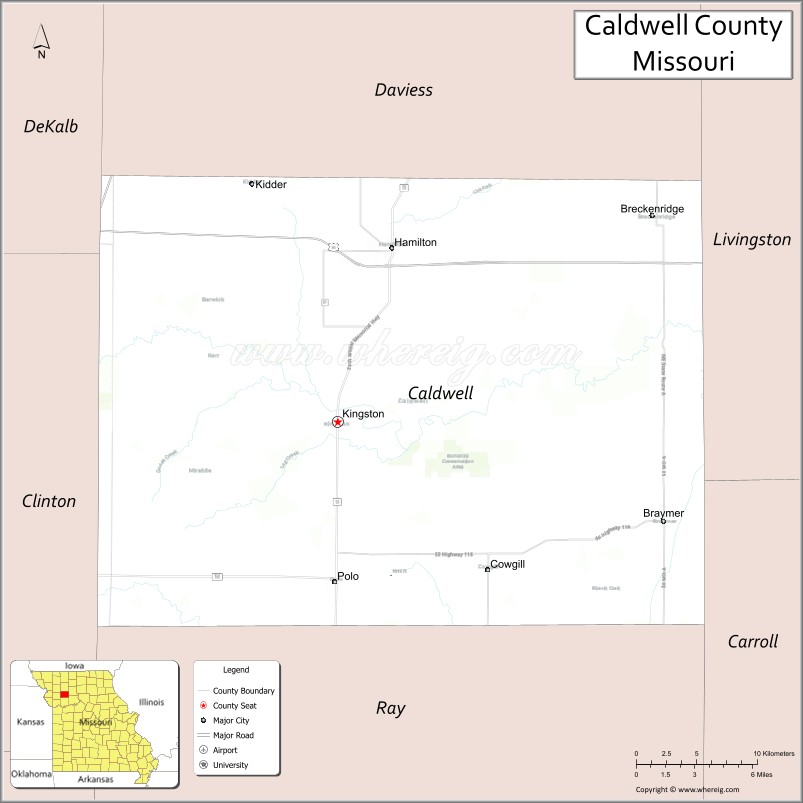
About Caldwell County Map, Missouri: The map showing the county boundary, county seat, major cities, highways, water bodies and neighbouring counties.
Related Missouri Maps & Info
Caldwell County, Missouri
Caldwell County is a county located in the U.S. state of Missouri. It's county seat is Kingston. As per 2020 census, the population of Caldwell County is 8897 people and population density is square miles. According to the United States Census Bureau, the county has a total area of 429 sq mi (1,111 km2). Caldwell County was established on 1836.
Caldwell County Facts
| Continent | North America |
| Country | United States |
| State | Missouri |
| County Seat | Kingston |
| Largest City/Town | Hamilton |
| Established | 1836 |
| Total Area | 429 sq mi (1,111 sq km) |
| Land Area | 426 sq mi (1,103 sq km) |
| Water Area | 3 sq mi (8 sq km) |
| Population | 8,815 (Census 2020) |
| Population Density | 20.7 people per sq mi |
| Time Zone | Central Time Zone (CST/CDT) |
| Major Highways | U.S. Route 36, Missouri Route 13, Missouri Route 116 |
| Major Rivers | Grand River, Shoal Creek |
| Neighboring Counties | Daviess County, Livingston County, Carroll County, Ray County, Clinton County, DeKalb County |
| Famous For | J.C. Penney birthplace, Mormon history, agriculture, and northwest Missouri prairie landscapes |
| Top Attractions | J.C. Penney Museum, Far West historical site, Hamilton quilting district, and Watkins Woolen Mill nearby region |
| Official Website | Official Website |
About Caldwell County
Caldwell County is located in northwestern Missouri in the central United States and was established in 1836. The county seat is Kingston, while Hamilton is the largest city. The county is known for its agricultural heritage, Mormon historical sites, prairie landscapes, and the birthplace of retail businessman J.C. Penney.
Cities and Towns in Caldwell County, Missouri
| City/Town | Population (Census 2020) | Latitude & Longitude |
|---|---|---|
| Hamilton | 1,690 | 39.7428°N, 93.9980°W |
| Kingston (county seat) | 281 | 39.6453°N, 94.0388°W |
| Breckenridge | 318 | 39.7656°N, 93.8016°W |
| Polo | 523 | 39.5531°N, 94.0402°W |
| Braymer | 821 | 39.5992°N, 93.7972°W |
| Cowgill | 188 | 39.5847°N, 93.8958°W |
What are the Golf Courses in Caldwell County
| Golf Course | Location | Latitude & Longitude |
|---|---|---|
| Hamilton Golf & Country Club | Hamilton | 39.7486°N, 94.0062°W |
| Polo Hills Recreation Golf Area | Polo | 39.5594°N, 94.0471°W |
Major Roads and Highways in Caldwell County
Major highways connect the county with northwest Missouri communities and Kansas City regional areas.
- U.S. Route 36 - major east-west transportation corridor across northern Missouri
- Missouri Route 13 - north-south highway serving rural communities
- Missouri Route 116 - regional route connecting local towns and farmland areas
What are Neighboring Counties of Caldwell County
- Livingston County (north)
- Carroll County (east)
- Ray County (south)
- Clinton County (west)
- Daviess County (northwest)
- DeKalb County (southwest)
What Are the Top Attractions in Caldwell County
The county offers a mix of historical attractions, prairie scenery, and cultural heritage sites.
- J.C. Penney Museum - birthplace museum honoring the famous retail entrepreneur
- Far West Historical Site - important Mormon settlement and church history landmark
- Hamilton Quilting District - popular shopping destination known for quilting and crafts
- Watkins Woolen Mill nearby region - historic mill and state park with trails and exhibits
- Kingston Historic Courthouse Area - preserved architecture and local history attractions
- Grand River Recreation Areas - fishing, wildlife viewing, and scenic countryside
- Northwest Missouri Scenic Drives - rolling farmland and prairie landscapes
- Braymer Community Parks - recreation facilities and local outdoor activities
- Historic Rural Churches and Schoolhouses - preserved 19th-century structures
- Community Festivals in Hamilton - craft fairs, quilting events, and seasonal celebrations
What Is the Distance from Caldwell County to Nearby Cities
The following distances are measured by road (driving).
- Hamilton to Kansas City (Jackson County), Missouri - 66 mi (106 km)
- Hamilton to St. Joseph (Buchanan County), Missouri - 61 mi (98 km)
- Hamilton to Chillicothe (Livingston County), Missouri - 32 mi (51 km)
- Hamilton to Liberty (Clay County), Missouri - 52 mi (84 km)
- Hamilton to Kingston (Caldwell County), Missouri - 11 mi (18 km)
- Hamilton to Braymer (Caldwell County), Missouri - 17 mi (27 km)
- Hamilton to Columbia (Boone County), Missouri - 132 mi (212 km)
- Hamilton to Des Moines (Polk County), Iowa - 188 mi (303 km)
- Hamilton to Omaha (Douglas County), Nebraska - 171 mi (275 km)
- Hamilton to Saint Louis (St. Louis City), Missouri - 285 mi (459 km)
- Hamilton to Minneapolis (Hennepin County), Minnesota - 436 mi (702 km)
- Hamilton to Denver (Denver County), Colorado - 614 mi (988 km)
- Hamilton to Chicago (Cook County), Illinois - 501 mi (806 km)
FAQs about Caldwell County
Caldwell County is located in northwestern Missouri in the United States.
Caldwell County had a population of 8,815 according to the 2020 United States Census.
Caldwell County is known for J.C. Penney history, Mormon heritage sites, agriculture, and prairie landscapes.
The county is served by U.S. Route 36, Missouri Route 13, and Missouri Route 116.
Yes, Caldwell County includes golf facilities such as Hamilton Golf & Country Club and Polo Hills Recreation Golf Area.
References
- QuickFacts - U.S. Census Bureau
- United States Census Bureau
- United States Geological Survey (USGS)
- National Geodetic Survey
- Official Website
- Adair County Map
- Andrew County Map
- Atchison County Map
- Audrain County Map
- Barry County Map
- Barton County Map
- Bates County Map
- Benton County Map
- Bollinger County Map
- Boone County Map
- Buchanan County Map
- Butler County Map
- Caldwell County Map
- Callaway County Map
- Camden County Map
- Cape Girardeau County Map
- Carroll County Map
- Carter County Map
- Cass County Map
- Cedar County Map
- Chariton County Map
- Christian County Map
- Clark County Map
- Clay County Map
- Clinton County Map
- Cole County Map
- Cooper County Map
- Crawford County Map
- Dade County Map
- Dallas County Map
- Daviess County Map
- DeKalb County Map
- Dent County Map
- Douglas County Map
- Dunklin County Map
- Franklin County Map
- Gasconade County Map
- Gentry County Map
- Greene County Map
- Grundy County Map
- Harrison County Map
- Henry County Map
- Hickory County Map
- Holt County Map
- Howard County Map
- Howell County Map
- Iron County Map
- Jackson County Map
- Jasper County Map
- Jefferson County Map
- Johnson County Map
- Knox County Map
- Laclede County Map
- Lafayette County Map
- Lawrence County Map
- Lewis County Map
- Lincoln County Map
- Linn County Map
- Livingston County Map
- McDonald County Map
- Macon County Map
- Madison County Map
- Maries County Map
- Marion County Map
- Mercer County Map
- Miller County Map
- Mississippi County Map
- Moniteau County Map
- Monroe County Map
- Montgomery County Map
- Morgan County Map
- New Madrid County Map
- Newton County Map
- Nodaway County Map
- Oregon County Map
- Osage County Map
- Ozark County Map
- Pemiscot County Map
- Perry County Map
- Pettis County Map
- Phelps County Map
- Pike County Map
- Platte County Map
- Polk County Map
- Pulaski County Map
- Putnam County Map
- Ralls County Map
- Randolph County Map
- Ray County Map
- Reynolds County Map
- Ripley County Map
- St Charles County Map
- St Clair County Map
- Ste Genevieve County Map
- St Francois County Map
- St Louis County Map
- Saline County Map
- Schuyler County Map
- Scotland County Map
- Scott County Map
- Shannon County Map
- Shelby County Map
- Stoddard County Map
- Stone County Map
- Sullivan County Map
- Taney County Map
- Texas County Map
- Vernon County Map
- Warren County Map
- Washington County Map
- Wayne County Map
- Webster County Map
- Worth County Map
- Wright County Map
- St Louis County Map
- Alabama Counties
- Alaska boroughs
- Arizona Counties
- Arkansas Counties
- California County Map
- Colorado Counties
- Connecticut Counties
- Delaware Counties
- Florida County Map
- Georgia County Map
- Hawaii Counties
- Idaho Counties
- Illinois Counties
- Indiana Counties
- Iowa Counties
- Kansas Counties
- Kentucky Counties
- Louisiana Counties
- Maine Counties
- Maryland Counties
- Massachusetts Counties
- Michigan County Map
- Minnesota Counties
- Mississippi Counties
- Missouri Counties
- Montana Counties
- Nebraska Counties
- Nevada Counties
- New York Counties
- New Hampshire Counties
- New Jersey Counties
- New Mexico Counties
- North Carolina Counties
- North Dakota Counties
- Ohio County Map
- Oklahoma Counties
- Oregon Counties
- Pennsylvania Counties
- Rhode Island Counties
- South Carolina Counties
- South Dakota Counties
- Map of Tennessee
- Texas County Map
- Utah Counties
- Vermont Counties
- Virginia Counties
- Washington Counties
- West Virginia Counties
- Wisconsin Counties
- Wyoming Counties