Map of Cooper County - Cooper County is a county located in the U.S. state of Missouri. Cooper County Map showing cities, highways, important places and water bodies. Get Where is Cooper County located in the map, major cities in Cooper county, population, areas, and places of interest.
Map of Cooper County, Missouri
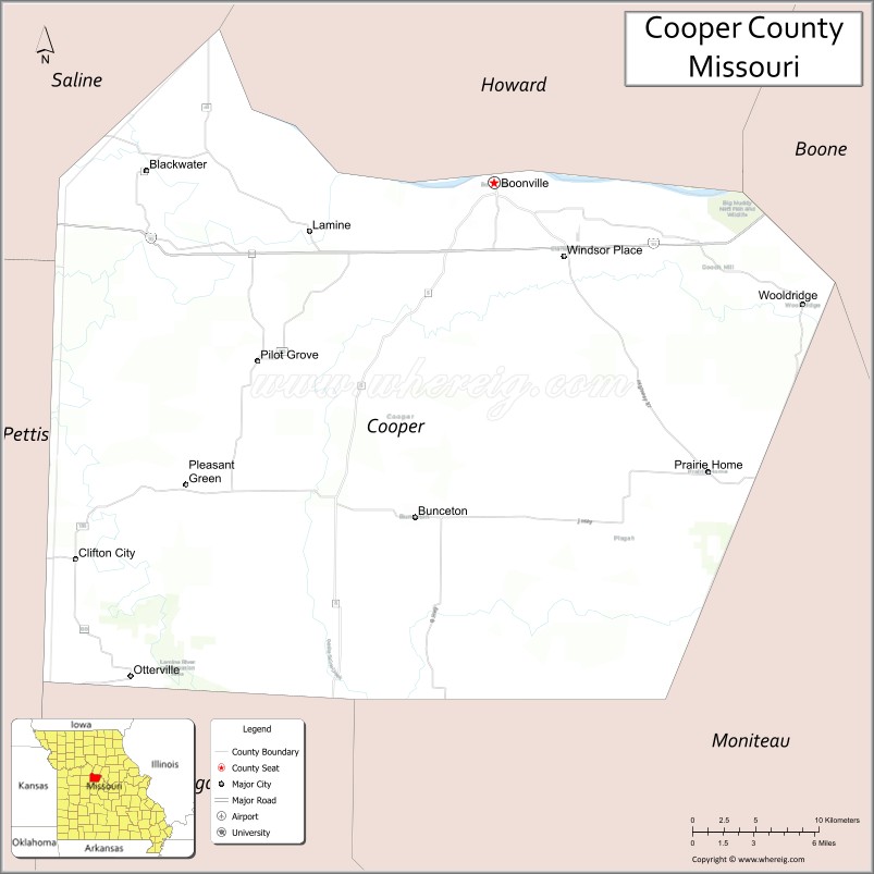
About Cooper County Map, Missouri: The map showing the county boundary, county seat, major cities, highways, water bodies and neighbouring counties.
Related Missouri Maps & Info
Cooper County, Missouri
Cooper County is a county located in the U.S. state of Missouri. It's county seat is Boonville. As per 2020 census, the population of Cooper County is 17115 people and population density is square miles. According to the United States Census Bureau, the county has a total area of 565 sq mi (1,463 km2). Cooper County was established on 1818.
Cooper County Facts
| Continent | North America |
| Country | United States |
| State | Missouri |
| County Seat | Boonville |
| Largest City/Town | Boonville |
| Established | 1818 |
| Total Area | 569 sq mi (1,474 sq km) |
| Land Area | 565 sq mi (1,463 sq km) |
| Water Area | 4 sq mi (11 sq km) |
| Population | 17,103 (Census 2020) |
| Population Density | 30.3 people per sq mi |
| Time Zone | Central Time Zone (CST/CDT) |
| Major Highways | Interstate 70, U.S. Route 40, Missouri Route 5, Missouri Route 87 |
| Major Rivers | Missouri River, Lamine River |
| Neighboring Counties | Howard County, Saline County, Pettis County, Moniteau County, Boone County |
| Famous For | Historic Boonville, Missouri River heritage, Katy Trail, and wineries |
| Top Attractions | Katy Trail State Park, Boonville historic district, Warm Springs Ranch, and Isle of Capri Casino nearby region |
| Official Website | Official Website |
About Cooper County
Cooper County is located in central Missouri along the Missouri River and was established in 1818. The county seat and largest city is Boonville. The county is known for its riverfront history, historic architecture, vineyards, Katy Trail recreation, and role in early Missouri settlement and trade.
Cities and Towns in Cooper County, Missouri
| City/Town | Population (Census 2020) | Latitude & Longitude |
|---|---|---|
| Boonville (county seat) | 7,964 | 38.9736°N, 92.7432°W |
| Pilot Grove | 768 | 38.8742°N, 92.9124°W |
| Prairie Home | 220 | 38.8100°N, 92.5910°W |
| Bunceton | 327 | 38.9792°N, 92.7935°W |
| Otterville | 454 | 38.7036°N, 92.9877°W |
| Blackwater nearby area | 162 | 38.9798°N, 92.9916°W |
What are the Golf Courses in Cooper County
| Golf Course | Location | Latitude & Longitude |
|---|---|---|
| Hail Ridge Golf Course | Boonville | 38.9897°N, 92.7584°W |
| Indian Foothills Park Golf Area | Boonville | 38.9661°N, 92.7345°W |
Major Roads and Highways in Cooper County
Major highways connect the county with Kansas City, Columbia, and important transportation routes across Missouri.
- Interstate 70 - major east-west interstate crossing central Missouri
- U.S. Route 40 - historic highway paralleling Interstate 70
- Missouri Route 5 - north-south regional transportation corridor
- Missouri Route 87 - route connecting river communities and rural areas
What are Neighboring Counties of Cooper County
- Howard County (north)
- Boone County (east)
- Moniteau County (southeast)
- Pettis County (southwest)
- Saline County (west)
What Are the Top Attractions in Cooper County
The county offers a mix of historic landmarks, river recreation, wineries, and scenic countryside.
- Katy Trail State Park - biking and hiking trail along the Missouri River corridor
- Boonville Historic District - preserved architecture, shops, and cultural attractions
- Warm Springs Ranch - home of the Budweiser Clydesdales breeding facility
- Isle of Capri Casino nearby region - entertainment, dining, and gaming attractions
- Missouri River Scenic Overlooks - panoramic river views and photography locations
- Cooper County Vineyards and Wineries - wine tasting and countryside tours
- Thespian Hall - one of Missouri’s oldest operating theaters
- Harley Park - sports facilities, playgrounds, and recreation areas
- Riverfront Boating and Fishing Areas - access to Missouri River recreation
- Historic Trails and Scenic Drives - rolling hills, farmland, and river valley landscapes
What Is the Distance from Cooper County to Nearby Cities
The following distances are measured by road (driving).
- Boonville to Columbia (Boone County), Missouri - 31 mi (50 km)
- Boonville to Jefferson City (Cole County), Missouri - 53 mi (85 km)
- Boonville to Kansas City (Jackson County), Missouri - 102 mi (164 km)
- Boonville to Sedalia (Pettis County), Missouri - 36 mi (58 km)
- Boonville to Pilot Grove (Cooper County), Missouri - 11 mi (18 km)
- Boonville to Otterville (Cooper County), Missouri - 21 mi (34 km)
- Boonville to Saint Louis (St. Louis City), Missouri - 165 mi (266 km)
- Boonville to Springfield (Greene County), Missouri - 174 mi (280 km)
- Boonville to Branson (Taney County), Missouri - 223 mi (359 km)
- Boonville to Omaha (Douglas County), Nebraska - 281 mi (452 km)
- Boonville to Tulsa (Tulsa County), Oklahoma - 288 mi (463 km)
- Boonville to Chicago (Cook County), Illinois - 427 mi (687 km)
- Boonville to Denver (Denver County), Colorado - 646 mi (1,040 km)
FAQs about Cooper County
Cooper County is located in central Missouri along the Missouri River.
Cooper County had a population of 17,103 according to the 2020 United States Census.
Cooper County is known for historic Boonville, Missouri River heritage, Katy Trail recreation, and wineries.
The county is served by Interstate 70, U.S. Route 40, Missouri Route 5, and Missouri Route 87.
Yes, Cooper County includes golf facilities such as Hail Ridge Golf Course and Indian Foothills Park Golf Area.
References
- QuickFacts - U.S. Census Bureau
- United States Census Bureau
- United States Geological Survey (USGS)
- National Geodetic Survey
- Official Website
- Adair County Map
- Andrew County Map
- Atchison County Map
- Audrain County Map
- Barry County Map
- Barton County Map
- Bates County Map
- Benton County Map
- Bollinger County Map
- Boone County Map
- Buchanan County Map
- Butler County Map
- Caldwell County Map
- Callaway County Map
- Camden County Map
- Cape Girardeau County Map
- Carroll County Map
- Carter County Map
- Cass County Map
- Cedar County Map
- Chariton County Map
- Christian County Map
- Clark County Map
- Clay County Map
- Clinton County Map
- Cole County Map
- Cooper County Map
- Crawford County Map
- Dade County Map
- Dallas County Map
- Daviess County Map
- DeKalb County Map
- Dent County Map
- Douglas County Map
- Dunklin County Map
- Franklin County Map
- Gasconade County Map
- Gentry County Map
- Greene County Map
- Grundy County Map
- Harrison County Map
- Henry County Map
- Hickory County Map
- Holt County Map
- Howard County Map
- Howell County Map
- Iron County Map
- Jackson County Map
- Jasper County Map
- Jefferson County Map
- Johnson County Map
- Knox County Map
- Laclede County Map
- Lafayette County Map
- Lawrence County Map
- Lewis County Map
- Lincoln County Map
- Linn County Map
- Livingston County Map
- McDonald County Map
- Macon County Map
- Madison County Map
- Maries County Map
- Marion County Map
- Mercer County Map
- Miller County Map
- Mississippi County Map
- Moniteau County Map
- Monroe County Map
- Montgomery County Map
- Morgan County Map
- New Madrid County Map
- Newton County Map
- Nodaway County Map
- Oregon County Map
- Osage County Map
- Ozark County Map
- Pemiscot County Map
- Perry County Map
- Pettis County Map
- Phelps County Map
- Pike County Map
- Platte County Map
- Polk County Map
- Pulaski County Map
- Putnam County Map
- Ralls County Map
- Randolph County Map
- Ray County Map
- Reynolds County Map
- Ripley County Map
- St Charles County Map
- St Clair County Map
- Ste Genevieve County Map
- St Francois County Map
- St Louis County Map
- Saline County Map
- Schuyler County Map
- Scotland County Map
- Scott County Map
- Shannon County Map
- Shelby County Map
- Stoddard County Map
- Stone County Map
- Sullivan County Map
- Taney County Map
- Texas County Map
- Vernon County Map
- Warren County Map
- Washington County Map
- Wayne County Map
- Webster County Map
- Worth County Map
- Wright County Map
- St Louis County Map
- Alabama Counties
- Alaska boroughs
- Arizona Counties
- Arkansas Counties
- California County Map
- Colorado Counties
- Connecticut Counties
- Delaware Counties
- Florida County Map
- Georgia County Map
- Hawaii Counties
- Idaho Counties
- Illinois Counties
- Indiana Counties
- Iowa Counties
- Kansas Counties
- Kentucky Counties
- Louisiana Counties
- Maine Counties
- Maryland Counties
- Massachusetts Counties
- Michigan County Map
- Minnesota Counties
- Mississippi Counties
- Missouri Counties
- Montana Counties
- Nebraska Counties
- Nevada Counties
- New York Counties
- New Hampshire Counties
- New Jersey Counties
- New Mexico Counties
- North Carolina Counties
- North Dakota Counties
- Ohio County Map
- Oklahoma Counties
- Oregon Counties
- Pennsylvania Counties
- Rhode Island Counties
- South Carolina Counties
- South Dakota Counties
- Map of Tennessee
- Texas County Map
- Utah Counties
- Vermont Counties
- Virginia Counties
- Washington Counties
- West Virginia Counties
- Wisconsin Counties
- Wyoming Counties