Map of Audrain County - Audrain County is a county located in the U.S. state of Missouri. Audrain County Map showing cities, highways, important places and water bodies. Get Where is Audrain County located in the map, major cities in Audrain county, population, areas, and places of interest.
Map of Audrain County, Missouri
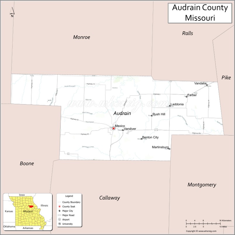
About Audrain County Map, Missouri: The map showing the county boundary, county seat, major cities, highways, water bodies and neighbouring counties.
Related Missouri Maps & Info
Audrain County, Missouri
Audrain County is a county located in the U.S. state of Missouri. It's county seat is Mexico. As per 2020 census, the population of Audrain County is 24982 people and population density is square miles. According to the United States Census Bureau, the county has a total area of 693 sq mi (1,795 km2). Audrain County was established on 1831.
Audrain County Facts
| Continent | North America |
| Country | United States |
| State | Missouri |
| County Seat | Mexico |
| Largest City/Town | Mexico |
| Established | 1836 |
| Total Area | 697 sq mi (1,805 sq km) |
| Land Area | 693 sq mi (1,795 sq km) |
| Water Area | 4 sq mi (10 sq km) |
| Population | 24,962 (Census 2020) |
| Population Density | 36.0 people per sq mi |
| Time Zone | Central Time Zone (CST/CDT) |
| Major Highways | U.S. Route 54, U.S. Route 54 Business, Missouri Route 15, Missouri Route 22 |
| Major Rivers | Salt River, Cuivre River nearby region |
| Neighboring Counties | Monroe County, Ralls County, Pike County, Montgomery County, Callaway County, Boone County |
| Famous For | Agriculture, historic brick architecture, Missouri Military Academy, and northeast Missouri heritage |
| Top Attractions | Missouri Military Academy, Green Estate Park, Audrain County Historical Museum, and downtown Mexico |
| Official Website | Official Website |
About Audrain County
Audrain County is located in northeastern Missouri in the central United States and was established in 1836. The county seat and largest city is Mexico. The county is known for its agricultural economy, historic architecture, educational institutions, and central location within northeast Missouri.
Cities and Towns in Audrain County, Missouri
| City/Town | Population (Census 2020) | Latitude & Longitude |
|---|---|---|
| Mexico (county seat) | 11,874 | 39.1698°N, 91.8829°W |
| Vandalia | 3,899 | 39.3106°N, 91.4888°W |
| Laddonia | 527 | 39.2375°N, 91.6460°W |
| Martinsburg | 267 | 39.0950°N, 91.6379°W |
| Farber | 241 | 39.2656°N, 91.5727°W |
| Rush Hill | 124 | 39.2069°N, 91.6805°W |
What are the Golf Courses in Audrain County
| Golf Course | Location | Latitude & Longitude |
|---|---|---|
| Arthur Hills Golf Course | Mexico | 39.1764°N, 91.8901°W |
| Mexico Country Club | Mexico | 39.1607°N, 91.9048°W |
Major Roads and Highways in Audrain County
Major highways connect the county with central and northeastern Missouri communities.
- U.S. Route 54 - major east-west transportation corridor through Missouri
- Missouri Route 15 - regional north-south highway
- Missouri Route 22 - route connecting agricultural communities and local towns
What are Neighboring Counties of Audrain County
- Monroe County (north)
- Ralls County (northeast)
- Pike County (east)
- Montgomery County (south)
- Callaway County (southwest)
- Boone County (west)
What Are the Top Attractions in Audrain County
The county offers a mix of historic landmarks, educational attractions, and outdoor recreation.
- Missouri Military Academy - historic military boarding school with notable architecture
- Green Estate Park - public park featuring trails, sports facilities, and picnic areas
- Audrain County Historical Museum - exhibits on local history, agriculture, and pioneer settlement
- Downtown Mexico - historic district with shops, restaurants, and cultural venues
- Teal Lake Recreation Area - fishing, walking trails, and outdoor recreation
- Vandalia Historic Sites - landmarks connected to railroad and agricultural history
- Northeast Missouri Scenic Drives - countryside routes through farmland and rolling landscapes
- Mexico Cinema and Arts Venues - local entertainment and cultural events
- Historic Churches and Courthouses - preserved 19th-century architecture throughout the county
- Audrain County Fairgrounds - annual fairs, rodeos, and community celebrations
What Is the Distance from Audrain County to Nearby Cities
The following distances are measured by road (driving).
- Mexico to Columbia (Boone County), Missouri - 43 mi (69 km)
- Mexico to Jefferson City (Cole County), Missouri - 67 mi (108 km)
- Mexico to Hannibal (Marion County), Missouri - 77 mi (124 km)
- Mexico to Saint Louis (St. Louis City), Missouri - 116 mi (187 km)
- Mexico to Vandalia (Audrain County), Missouri - 28 mi (45 km)
- Mexico to Laddonia (Audrain County), Missouri - 18 mi (29 km)
- Mexico to Kansas City (Jackson County), Missouri - 156 mi (251 km)
- Mexico to Springfield (Greene County), Missouri - 196 mi (315 km)
- Mexico to Quincy (Adams County), Illinois - 93 mi (150 km)
- Mexico to Des Moines (Polk County), Iowa - 244 mi (393 km)
- Mexico to Chicago (Cook County), Illinois - 343 mi (552 km)
- Mexico to Minneapolis (Hennepin County), Minnesota - 511 mi (822 km)
- Mexico to Denver (Denver County), Colorado - 695 mi (1,118 km)
FAQs about Audrain County
Audrain County is located in northeastern Missouri in the United States.
Audrain County had a population of 24,962 according to the 2020 United States Census.
Audrain County is known for agriculture, historic architecture, Missouri Military Academy, and regional heritage.
The county is served by U.S. Route 54, Missouri Route 15, and Missouri Route 22.
Yes, Audrain County includes golf facilities such as Arthur Hills Golf Course and Mexico Country Club.
References
- QuickFacts - U.S. Census Bureau
- United States Census Bureau
- United States Geological Survey (USGS)
- National Geodetic Survey
- Official Website
- Adair County Map
- Andrew County Map
- Atchison County Map
- Audrain County Map
- Barry County Map
- Barton County Map
- Bates County Map
- Benton County Map
- Bollinger County Map
- Boone County Map
- Buchanan County Map
- Butler County Map
- Caldwell County Map
- Callaway County Map
- Camden County Map
- Cape Girardeau County Map
- Carroll County Map
- Carter County Map
- Cass County Map
- Cedar County Map
- Chariton County Map
- Christian County Map
- Clark County Map
- Clay County Map
- Clinton County Map
- Cole County Map
- Cooper County Map
- Crawford County Map
- Dade County Map
- Dallas County Map
- Daviess County Map
- DeKalb County Map
- Dent County Map
- Douglas County Map
- Dunklin County Map
- Franklin County Map
- Gasconade County Map
- Gentry County Map
- Greene County Map
- Grundy County Map
- Harrison County Map
- Henry County Map
- Hickory County Map
- Holt County Map
- Howard County Map
- Howell County Map
- Iron County Map
- Jackson County Map
- Jasper County Map
- Jefferson County Map
- Johnson County Map
- Knox County Map
- Laclede County Map
- Lafayette County Map
- Lawrence County Map
- Lewis County Map
- Lincoln County Map
- Linn County Map
- Livingston County Map
- McDonald County Map
- Macon County Map
- Madison County Map
- Maries County Map
- Marion County Map
- Mercer County Map
- Miller County Map
- Mississippi County Map
- Moniteau County Map
- Monroe County Map
- Montgomery County Map
- Morgan County Map
- New Madrid County Map
- Newton County Map
- Nodaway County Map
- Oregon County Map
- Osage County Map
- Ozark County Map
- Pemiscot County Map
- Perry County Map
- Pettis County Map
- Phelps County Map
- Pike County Map
- Platte County Map
- Polk County Map
- Pulaski County Map
- Putnam County Map
- Ralls County Map
- Randolph County Map
- Ray County Map
- Reynolds County Map
- Ripley County Map
- St Charles County Map
- St Clair County Map
- Ste Genevieve County Map
- St Francois County Map
- St Louis County Map
- Saline County Map
- Schuyler County Map
- Scotland County Map
- Scott County Map
- Shannon County Map
- Shelby County Map
- Stoddard County Map
- Stone County Map
- Sullivan County Map
- Taney County Map
- Texas County Map
- Vernon County Map
- Warren County Map
- Washington County Map
- Wayne County Map
- Webster County Map
- Worth County Map
- Wright County Map
- St Louis County Map
- Alabama Counties
- Alaska boroughs
- Arizona Counties
- Arkansas Counties
- California County Map
- Colorado Counties
- Connecticut Counties
- Delaware Counties
- Florida County Map
- Georgia County Map
- Hawaii Counties
- Idaho Counties
- Illinois Counties
- Indiana Counties
- Iowa Counties
- Kansas Counties
- Kentucky Counties
- Louisiana Counties
- Maine Counties
- Maryland Counties
- Massachusetts Counties
- Michigan County Map
- Minnesota Counties
- Mississippi Counties
- Missouri Counties
- Montana Counties
- Nebraska Counties
- Nevada Counties
- New York Counties
- New Hampshire Counties
- New Jersey Counties
- New Mexico Counties
- North Carolina Counties
- North Dakota Counties
- Ohio County Map
- Oklahoma Counties
- Oregon Counties
- Pennsylvania Counties
- Rhode Island Counties
- South Carolina Counties
- South Dakota Counties
- Map of Tennessee
- Texas County Map
- Utah Counties
- Vermont Counties
- Virginia Counties
- Washington Counties
- West Virginia Counties
- Wisconsin Counties
- Wyoming Counties