Map of Buchanan County - Buchanan County is a county located in the U.S. state of Missouri. Buchanan County Map showing cities, highways, important places and water bodies. Get Where is Buchanan County located in the map, major cities in Buchanan county, population, areas, and places of interest.
Map of Buchanan County, Missouri
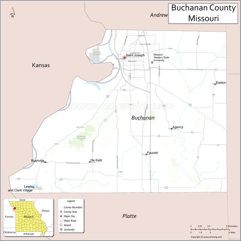
About Buchanan County Map, Missouri: The map showing the county boundary, county seat, major cities, highways, water bodies and neighbouring counties.
Related Missouri Maps & Info
Buchanan County, Missouri
Buchanan County is a county located in the U.S. state of Missouri. It's county seat is Saint Joseph. As per 2020 census, the population of Buchanan County is 83853 people and population density is square miles. According to the United States Census Bureau, the county has a total area of 410 sq mi (1,062 km2). Buchanan County was established on 1838.
Buchanan County Facts
| Continent | North America |
| Country | United States |
| State | Missouri |
| County Seat | St. Joseph |
| Largest City/Town | St. Joseph |
| Established | 1838 |
| Total Area | 415 sq mi (1,075 sq km) |
| Land Area | 408 sq mi (1,057 sq km) |
| Water Area | 7 sq mi (18 sq km) |
| Population | 89,490 (Census 2020) |
| Population Density | 219.3 people per sq mi |
| Time Zone | Central Time Zone (CST/CDT) |
| Major Highways | Interstate 29, Interstate 229, U.S. Route 36, U.S. Route 59, U.S. Route 71 |
| Major Rivers | Missouri River, Platte River nearby region |
| Neighboring Counties | Andrew County, Clinton County, DeKalb County, Platte County |
| Famous For | Pony Express history, St. Joseph museums, Missouri River commerce, and historic architecture |
| Top Attractions | Pony Express National Museum, Jesse James Home Museum, Krug Park, and downtown St. Joseph |
| Official Website | Official Website |
About Buchanan County
Buchanan County is located in northwestern Missouri in the central United States and was established in 1838. The county seat and largest city is St. Joseph. The county is known for its important role in westward expansion, Pony Express history, historic neighborhoods, and Missouri River transportation heritage.
Cities and Towns in Buchanan County, Missouri
| City/Town | Population (Census 2020) | Latitude & Longitude |
|---|---|---|
| St. Joseph (county seat) | 72,473 | 39.7675°N, 94.8467°W |
| Easton | 230 | 39.7850°N, 94.6636°W |
| Rushville | 238 | 39.5858°N, 95.0372°W |
| Agency | 684 | 39.6444°N, 94.6980°W |
| DeKalb | 76 | 39.6136°N, 94.4441°W |
| Lewis and Clark Village | 54 | 39.7870°N, 94.8159°W |
What are the Golf Courses in Buchanan County
| Golf Course | Location | Latitude & Longitude |
|---|---|---|
| St. Joseph Country Club | St. Joseph | 39.7612°N, 94.8014°W |
| Fairview Golf Course | St. Joseph | 39.7798°N, 94.8235°W |
| Moila Country Club | St. Joseph | 39.7362°N, 94.8574°W |
Major Roads and Highways in Buchanan County
Major highways make Buchanan County an important transportation and commercial center in northwest Missouri.
- Interstate 29 - major north-south interstate through western Missouri
- Interstate 229 - loop route serving downtown St. Joseph
- U.S. Route 36 - major east-west transportation corridor
- U.S. Route 59 - regional north-south highway
- U.S. Route 71 - important commercial route through the county
What are Neighboring Counties of Buchanan County
- Andrew County (north)
- DeKalb County (east)
- Clinton County (southeast)
- Platte County (south)
What Are the Top Attractions in Buchanan County
The county offers a mix of historical attractions, museums, parks, and Missouri River heritage.
- Pony Express National Museum - exhibits dedicated to the famous mail delivery service
- Jesse James Home Museum - historic house where outlaw Jesse James was killed
- Krug Park - scenic urban park with gardens, trails, and recreational facilities
- Downtown St. Joseph - historic architecture, restaurants, shopping, and entertainment
- Remington Nature Center - Missouri River ecology exhibits and educational programs
- Albrecht-Kemper Museum of Art - regional art collections and rotating exhibits
- Glore Psychiatric Museum - unique museum focused on the history of mental health treatment
- Missouri Theater - restored historic theater hosting performances and events
- Riverfront Park - walking trails and scenic Missouri River views
- Walter Cronkite Memorial - tribute to the legendary journalist born in St. Joseph
What Is the Distance from Buchanan County to Nearby Cities
The following distances are measured by road (driving).
- St. Joseph to Kansas City (Jackson County), Missouri - 55 mi (89 km)
- St. Joseph to Maryville (Nodaway County), Missouri - 45 mi (72 km)
- St. Joseph to Omaha (Douglas County), Nebraska - 128 mi (206 km)
- St. Joseph to Topeka (Shawnee County), Kansas - 76 mi (122 km)
- St. Joseph to Agency (Buchanan County), Missouri - 12 mi (19 km)
- St. Joseph to Easton (Buchanan County), Missouri - 12 mi (19 km)
- St. Joseph to Columbia (Boone County), Missouri - 170 mi (274 km)
- St. Joseph to Wichita (Sedgwick County), Kansas - 247 mi (398 km)
- St. Joseph to Saint Louis (St. Louis City), Missouri - 303 mi (488 km)
- St. Joseph to Des Moines (Polk County), Iowa - 187 mi (301 km)
- St. Joseph to Minneapolis (Hennepin County), Minnesota - 437 mi (703 km)
- St. Joseph to Denver (Denver County), Colorado - 607 mi (977 km)
- St. Joseph to Chicago (Cook County), Illinois - 497 mi (800 km)
FAQs about Buchanan County
Buchanan County is located in northwestern Missouri along the Missouri River.
Buchanan County had a population of 89,490 according to the 2020 United States Census.
Buchanan County is known for Pony Express history, St. Joseph landmarks, museums, and Missouri River heritage.
The county is served by Interstate 29, Interstate 229, U.S. Route 36, U.S. Route 59, and U.S. Route 71.
Yes, Buchanan County includes golf facilities such as St. Joseph Country Club, Fairview Golf Course, and Moila Country Club.
References
- QuickFacts - U.S. Census Bureau
- United States Census Bureau
- United States Geological Survey (USGS)
- National Geodetic Survey
- Official Website
- Adair County Map
- Andrew County Map
- Atchison County Map
- Audrain County Map
- Barry County Map
- Barton County Map
- Bates County Map
- Benton County Map
- Bollinger County Map
- Boone County Map
- Buchanan County Map
- Butler County Map
- Caldwell County Map
- Callaway County Map
- Camden County Map
- Cape Girardeau County Map
- Carroll County Map
- Carter County Map
- Cass County Map
- Cedar County Map
- Chariton County Map
- Christian County Map
- Clark County Map
- Clay County Map
- Clinton County Map
- Cole County Map
- Cooper County Map
- Crawford County Map
- Dade County Map
- Dallas County Map
- Daviess County Map
- DeKalb County Map
- Dent County Map
- Douglas County Map
- Dunklin County Map
- Franklin County Map
- Gasconade County Map
- Gentry County Map
- Greene County Map
- Grundy County Map
- Harrison County Map
- Henry County Map
- Hickory County Map
- Holt County Map
- Howard County Map
- Howell County Map
- Iron County Map
- Jackson County Map
- Jasper County Map
- Jefferson County Map
- Johnson County Map
- Knox County Map
- Laclede County Map
- Lafayette County Map
- Lawrence County Map
- Lewis County Map
- Lincoln County Map
- Linn County Map
- Livingston County Map
- McDonald County Map
- Macon County Map
- Madison County Map
- Maries County Map
- Marion County Map
- Mercer County Map
- Miller County Map
- Mississippi County Map
- Moniteau County Map
- Monroe County Map
- Montgomery County Map
- Morgan County Map
- New Madrid County Map
- Newton County Map
- Nodaway County Map
- Oregon County Map
- Osage County Map
- Ozark County Map
- Pemiscot County Map
- Perry County Map
- Pettis County Map
- Phelps County Map
- Pike County Map
- Platte County Map
- Polk County Map
- Pulaski County Map
- Putnam County Map
- Ralls County Map
- Randolph County Map
- Ray County Map
- Reynolds County Map
- Ripley County Map
- St Charles County Map
- St Clair County Map
- Ste Genevieve County Map
- St Francois County Map
- St Louis County Map
- Saline County Map
- Schuyler County Map
- Scotland County Map
- Scott County Map
- Shannon County Map
- Shelby County Map
- Stoddard County Map
- Stone County Map
- Sullivan County Map
- Taney County Map
- Texas County Map
- Vernon County Map
- Warren County Map
- Washington County Map
- Wayne County Map
- Webster County Map
- Worth County Map
- Wright County Map
- St Louis County Map
- Alabama Counties
- Alaska boroughs
- Arizona Counties
- Arkansas Counties
- California County Map
- Colorado Counties
- Connecticut Counties
- Delaware Counties
- Florida County Map
- Georgia County Map
- Hawaii Counties
- Idaho Counties
- Illinois Counties
- Indiana Counties
- Iowa Counties
- Kansas Counties
- Kentucky Counties
- Louisiana Counties
- Maine Counties
- Maryland Counties
- Massachusetts Counties
- Michigan County Map
- Minnesota Counties
- Mississippi Counties
- Missouri Counties
- Montana Counties
- Nebraska Counties
- Nevada Counties
- New York Counties
- New Hampshire Counties
- New Jersey Counties
- New Mexico Counties
- North Carolina Counties
- North Dakota Counties
- Ohio County Map
- Oklahoma Counties
- Oregon Counties
- Pennsylvania Counties
- Rhode Island Counties
- South Carolina Counties
- South Dakota Counties
- Map of Tennessee
- Texas County Map
- Utah Counties
- Vermont Counties
- Virginia Counties
- Washington Counties
- West Virginia Counties
- Wisconsin Counties
- Wyoming Counties