Map of Crawford County - Crawford County is a county located in the U.S. state of Missouri. Crawford County Map showing cities, highways, important places and water bodies. Get Where is Crawford County located in the map, major cities in Crawford county, population, areas, and places of interest.
Map of Crawford County, Missouri
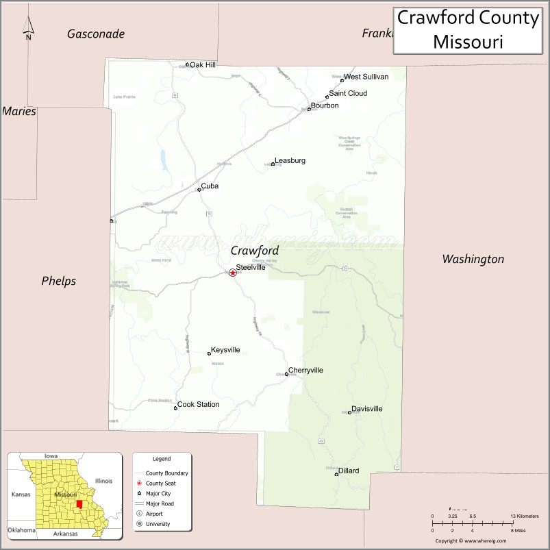
About Crawford County Map, Missouri: The map showing the county boundary, county seat, major cities, highways, water bodies and neighbouring counties.
Related Missouri Maps & Info
Crawford County, Missouri
Crawford County is a county located in the U.S. state of Missouri. It's county seat is Steelville. As per 2020 census, the population of Crawford County is 22807 people and population density is square miles. According to the United States Census Bureau, the county has a total area of 743 sq mi (1,924 km2). Crawford County was established on 1829.
Crawford County Facts
| Continent | North America |
| Country | United States |
| State | Missouri |
| County Seat | Steelville |
| Largest City/Town | Cuba |
| Established | 1829 |
| Total Area | 744 sq mi (1,927 sq km) |
| Land Area | 742 sq mi (1,922 sq km) |
| Water Area | 2 sq mi (5 sq km) |
| Population | 23,056 (Census 2020) |
| Population Density | 31.1 people per sq mi |
| Time Zone | Central Time Zone (CST/CDT) |
| Major Highways | Interstate 44, U.S. Route 63, Missouri Route 19 |
| Major Rivers | Meramec River, Huzzah Creek, Courtois Creek |
| Neighboring Counties | Franklin County, Gasconade County, Phelps County, Dent County, Washington County, Iron County |
| Famous For | Ozark scenery, floating rivers, caves, hiking, and outdoor recreation |
| Top Attractions | Meramec River, Onondaga Cave State Park nearby region, Mark Twain National Forest, and Cuba murals |
| Official Website | Official Website |
About Crawford County
Crawford County is located in east-central Missouri in the Ozarks region and was established in 1829. The county seat is Steelville, while Cuba is the largest city. The county is known for scenic rivers, caves, forests, outdoor recreation, and tourism centered around floating, camping, and hiking in the Ozark Highlands.
Cities and Towns in Crawford County, Missouri
| City/Town | Population (Census 2020) | Latitude & Longitude |
|---|---|---|
| Cuba | 3,356 | 38.0628°N, 91.4032°W |
| Steelville (county seat) | 1,642 | 37.9689°N, 91.3543°W |
| Bourbon | 1,632 | 38.1548°N, 91.2440°W |
| Leasburg | 338 | 38.1006°N, 91.2951°W |
| Cherryville nearby area | 221 | 37.8495°N, 91.2748°W |
| Cook Station nearby area | 67 | 37.8173°N, 91.4407°W |
What are the Golf Courses in Crawford County
| Golf Course | Location | Latitude & Longitude |
|---|---|---|
| Cuba Lakes Golf Course | Cuba | 38.0704°N, 91.4125°W |
| Meramec Lakes Golf Recreation Area | Steelville | 37.9758°N, 91.3602°W |
Major Roads and Highways in Crawford County
Major highways connect the county with St. Louis, Springfield, and the scenic Ozark recreation regions.
- Interstate 44 - major east-west interstate through central Missouri
- U.S. Route 63 - north-south highway serving rural and recreation communities
- Missouri Route 19 - scenic route through rivers, forests, and Ozark towns
What are Neighboring Counties of Crawford County
- Gasconade County (north)
- Franklin County (northeast)
- Washington County (east)
- Iron County (southeast)
- Dent County (southwest)
- Phelps County (west)
What Are the Top Attractions in Crawford County
The county offers a mix of rivers, forests, caves, and outdoor adventure destinations.
- Meramec River - floating, canoeing, kayaking, fishing, and camping opportunities
- Onondaga Cave State Park nearby region - cave tours, hiking trails, and river recreation
- Mark Twain National Forest - scenic drives, camping, hiking, and wildlife viewing
- Cuba Murals - outdoor public art displays throughout downtown Cuba
- Huzzah Creek Recreation Areas - swimming, rafting, and nature observation
- Steelville Outdoor Outfitters - guided float trips and camping services
- Meramec Springs nearby area - trout fishing and natural spring attractions
- Ozark Scenic Byways - rolling hills, forests, and panoramic overlooks
- Courtois Creek Recreation Areas - floating and wilderness camping destinations
- Historic Downtown Cuba - restaurants, antique shops, and Route 66 attractions
What Is the Distance from Crawford County to Nearby Cities
The following distances are measured by road (driving).
- Steelville to Saint Louis (St. Louis City), Missouri - 94 mi (151 km)
- Steelville to Rolla (Phelps County), Missouri - 32 mi (51 km)
- Steelville to Springfield (Greene County), Missouri - 145 mi (233 km)
- Steelville to Jefferson City (Cole County), Missouri - 87 mi (140 km)
- Steelville to Cuba (Crawford County), Missouri - 14 mi (23 km)
- Steelville to Bourbon (Crawford County), Missouri - 26 mi (42 km)
- Steelville to Branson (Taney County), Missouri - 212 mi (341 km)
- Steelville to Kansas City (Jackson County), Missouri - 225 mi (362 km)
- Steelville to Memphis (Shelby County), Tennessee - 308 mi (496 km)
- Steelville to Chicago (Cook County), Illinois - 366 mi (589 km)
- Steelville to Nashville (Davidson County), Tennessee - 350 mi (563 km)
- Steelville to Denver (Denver County), Colorado - 747 mi (1,202 km)
- Steelville to Minneapolis (Hennepin County), Minnesota - 609 mi (980 km)
FAQs about Crawford County
Crawford County is located in east-central Missouri in the Ozarks region.
Crawford County had a population of 23,056 according to the 2020 United States Census.
Crawford County is known for Ozark scenery, floating rivers, caves, hiking, and outdoor recreation.
The county is served by Interstate 44, U.S. Route 63, and Missouri Route 19.
Yes, Crawford County includes golf facilities such as Cuba Lakes Golf Course and Meramec Lakes Golf Recreation Area.
References
- QuickFacts - U.S. Census Bureau
- United States Census Bureau
- United States Geological Survey (USGS)
- National Geodetic Survey
- Official Website
- Adair County Map
- Andrew County Map
- Atchison County Map
- Audrain County Map
- Barry County Map
- Barton County Map
- Bates County Map
- Benton County Map
- Bollinger County Map
- Boone County Map
- Buchanan County Map
- Butler County Map
- Caldwell County Map
- Callaway County Map
- Camden County Map
- Cape Girardeau County Map
- Carroll County Map
- Carter County Map
- Cass County Map
- Cedar County Map
- Chariton County Map
- Christian County Map
- Clark County Map
- Clay County Map
- Clinton County Map
- Cole County Map
- Cooper County Map
- Crawford County Map
- Dade County Map
- Dallas County Map
- Daviess County Map
- DeKalb County Map
- Dent County Map
- Douglas County Map
- Dunklin County Map
- Franklin County Map
- Gasconade County Map
- Gentry County Map
- Greene County Map
- Grundy County Map
- Harrison County Map
- Henry County Map
- Hickory County Map
- Holt County Map
- Howard County Map
- Howell County Map
- Iron County Map
- Jackson County Map
- Jasper County Map
- Jefferson County Map
- Johnson County Map
- Knox County Map
- Laclede County Map
- Lafayette County Map
- Lawrence County Map
- Lewis County Map
- Lincoln County Map
- Linn County Map
- Livingston County Map
- McDonald County Map
- Macon County Map
- Madison County Map
- Maries County Map
- Marion County Map
- Mercer County Map
- Miller County Map
- Mississippi County Map
- Moniteau County Map
- Monroe County Map
- Montgomery County Map
- Morgan County Map
- New Madrid County Map
- Newton County Map
- Nodaway County Map
- Oregon County Map
- Osage County Map
- Ozark County Map
- Pemiscot County Map
- Perry County Map
- Pettis County Map
- Phelps County Map
- Pike County Map
- Platte County Map
- Polk County Map
- Pulaski County Map
- Putnam County Map
- Ralls County Map
- Randolph County Map
- Ray County Map
- Reynolds County Map
- Ripley County Map
- St Charles County Map
- St Clair County Map
- Ste Genevieve County Map
- St Francois County Map
- St Louis County Map
- Saline County Map
- Schuyler County Map
- Scotland County Map
- Scott County Map
- Shannon County Map
- Shelby County Map
- Stoddard County Map
- Stone County Map
- Sullivan County Map
- Taney County Map
- Texas County Map
- Vernon County Map
- Warren County Map
- Washington County Map
- Wayne County Map
- Webster County Map
- Worth County Map
- Wright County Map
- St Louis County Map
- Alabama Counties
- Alaska boroughs
- Arizona Counties
- Arkansas Counties
- California County Map
- Colorado Counties
- Connecticut Counties
- Delaware Counties
- Florida County Map
- Georgia County Map
- Hawaii Counties
- Idaho Counties
- Illinois Counties
- Indiana Counties
- Iowa Counties
- Kansas Counties
- Kentucky Counties
- Louisiana Counties
- Maine Counties
- Maryland Counties
- Massachusetts Counties
- Michigan County Map
- Minnesota Counties
- Mississippi Counties
- Missouri Counties
- Montana Counties
- Nebraska Counties
- Nevada Counties
- New York Counties
- New Hampshire Counties
- New Jersey Counties
- New Mexico Counties
- North Carolina Counties
- North Dakota Counties
- Ohio County Map
- Oklahoma Counties
- Oregon Counties
- Pennsylvania Counties
- Rhode Island Counties
- South Carolina Counties
- South Dakota Counties
- Map of Tennessee
- Texas County Map
- Utah Counties
- Vermont Counties
- Virginia Counties
- Washington Counties
- West Virginia Counties
- Wisconsin Counties
- Wyoming Counties