Map of Vernon County - Vernon County is a county located in the U.S. state of Missouri. Vernon County Map showing cities, highways, important places and water bodies. Get Where is Vernon County located in the map, major cities in Vernon county, population, areas, and places of interest.
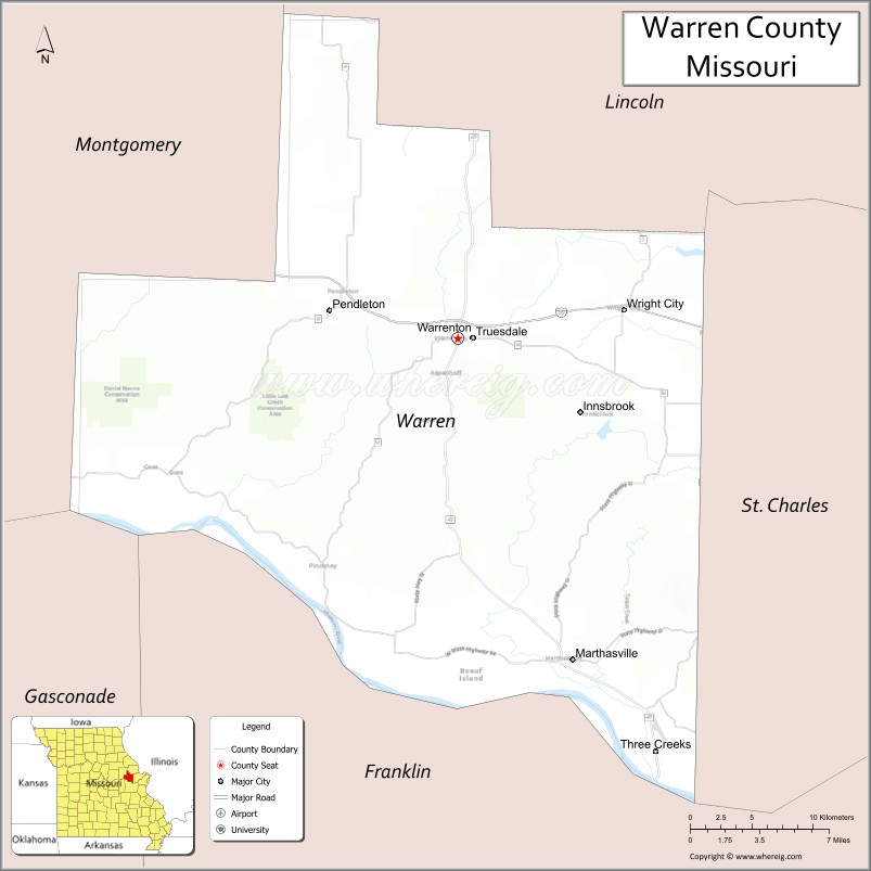
Map of Warren County, Missouri
About Vernon County Map, Missouri: The map showing the county boundary, county seat, major cities, highways, water bodies and neighbouring counties.
Related Missouri Maps & Info
Warren County, Missouri
Warren County is a county located in the U.S. state of Missouri. It's county seat is Warrenton. As per 2020 census, the population of Warren County is 36518 people and population density is square miles. According to the United States Census Bureau, the county has a total area of 432 sq mi (1,119 km2). Warren County was established on 1833.
Warren County Facts
| Continent | North America |
| Country | United States |
| State | Missouri |
| County Seat | Warrenton |
| Largest City/Town | Warrenton |
| Established | 1833 |
| Total Area | 438 sq mi (1,134 sq km) |
| Land Area | 429 sq mi (1,111 sq km) |
| Water Area | 9 sq mi (23 sq km) |
| Population | 35,734 (Census 2020) |
| Population Density | 83.3 people per sq mi |
| Time Zone | Central Time Zone (CST/CDT) |
| Major Highways | Interstate 70, U.S. Route 40, Missouri Route 47, Missouri Route 94 |
| Major Rivers | Missouri River |
| Neighboring Counties | St. Charles County, Franklin County, Montgomery County, Lincoln County, Gasconade County |
| Famous For | Missouri Wine Country, Katy Trail, scenic river valleys, and rural heritage |
| Top Attractions | Katy Trail State Park, Cedar Lake Cellars, Missouri River recreation, and scenic wineries |
| Official Website | Official Website |
About Warren County
Warren County is located in east-central Missouri west of St. Louis and was established in 1833. The county seat and largest city is Warrenton. The county is known for wineries, scenic Missouri River landscapes, recreational trails, and growing suburban-rural communities.
Cities and Towns in Warren County, Missouri
| City/Town | Population (Census 2020) | Latitude & Longitude |
|---|---|---|
| Warrenton (county seat) | 8,429 | 38.8114°N, 91.1410°W |
| Wright City | 4,146 | 38.8270°N, 91.0207°W |
| Truesdale | 732 | 38.8111°N, 91.1363°W |
| Marthasville | 1,184 | 38.6298°N, 91.0599°W |
| Innsbrook nearby region | 552 | 38.7690°N, 91.0608°W |
| Pendleton nearby area | 43 | 38.7642°N, 91.3815°W |
What are the Golf Courses in Warren County
| Golf Course | Location | Latitude & Longitude |
|---|---|---|
| Innsbrook Resort Golf Course | Innsbrook | 38.7747°N, 91.0588°W |
| Country Lake Golf Club | Warrenton | 38.8229°N, 91.1542°W |
| Bear Creek Golf Club | Wright City nearby region | 38.8362°N, 91.0304°W |
Major Roads and Highways in Warren County
Major highways connect Warren County with St. Louis, Columbia, and Missouri River valley communities.
- Interstate 70 - major east-west interstate corridor through Missouri
- U.S. Route 40 - historic transportation route paralleling Interstate 70
- Missouri Route 47 - regional north-south highway connecting rural towns
- Missouri Route 94 - scenic highway through Missouri Wine Country
What are Neighboring Counties of Warren County
- Lincoln County (north)
- St. Charles County (east)
- Franklin County (south)
- Gasconade County (southwest)
- Montgomery County (west)
What Are the Top Attractions in Warren County
The county offers scenic river landscapes, wineries, recreational trails, and outdoor attractions.
- Katy Trail State Park - biking, hiking, and Missouri River recreation
- Cedar Lake Cellars - winery, events, and scenic countryside views
- Missouri River Recreation Areas - boating, fishing, and riverfront activities
- Innsbrook Resort - lakes, golf, hiking, and vacation recreation
- Missouri Wine Country Scenic Drives - vineyards and rolling countryside photography
- Historic Downtown Warrenton - local shops, dining, and community events
- Parks and Campgrounds - outdoor family recreation and camping
- Community Festivals and Wine Events - seasonal celebrations and cultural gatherings
- Fishing Lakes and Nature Areas - relaxation and wildlife observation
- Historic Rural Barns and Farmland - preserved Missouri countryside heritage
What Is the Distance from Warren County to Nearby Cities
The following distances are measured by road (driving).
- Warrenton to St. Louis (St. Louis City), Missouri - 56 mi (90 km)
- Warrenton to Columbia (Boone County), Missouri - 91 mi (146 km)
- Warrenton to Jefferson City (Cole County), Missouri - 95 mi (153 km)
- Warrenton to St. Charles (St. Charles County), Missouri - 35 mi (56 km)
- Warrenton to Wright City (Warren County), Missouri - 8 mi (13 km)
- Warrenton to Marthasville (Warren County), Missouri - 16 mi (26 km)
- Warrenton to Springfield (Greene County), Missouri - 216 mi (348 km)
- Warrenton to Kansas City (Jackson County), Missouri - 195 mi (314 km)
- Warrenton to Chicago (Cook County), Illinois - 348 mi (560 km)
- Warrenton to Indianapolis (Marion County), Indiana - 269 mi (433 km)
- Warrenton to Dallas (Dallas County), Texas - 626 mi (1,007 km)
- Warrenton to Nashville (Davidson County), Tennessee - 341 mi (549 km)
- Warrenton to Denver (Denver County), Colorado - 794 mi (1,278 km)
FAQs about Warren County
Warren County is located in east-central Missouri west of St. Louis.
Warren County had a population of 35,734 according to the 2020 United States Census.
Warren County is known for Missouri Wine Country, Katy Trail recreation, and scenic river valleys.
The county is served by Interstate 70, U.S. Route 40, Missouri Route 47, and Missouri Route 94.
Yes, Warren County includes golf facilities such as Innsbrook Resort Golf Course and Country Lake Golf Club.
References
- QuickFacts - U.S. Census Bureau
- United States Census Bureau
- United States Geological Survey (USGS)
- National Geodetic Survey
- Official Website
- Adair County Map
- Andrew County Map
- Atchison County Map
- Audrain County Map
- Barry County Map
- Barton County Map
- Bates County Map
- Benton County Map
- Bollinger County Map
- Boone County Map
- Buchanan County Map
- Butler County Map
- Caldwell County Map
- Callaway County Map
- Camden County Map
- Cape Girardeau County Map
- Carroll County Map
- Carter County Map
- Cass County Map
- Cedar County Map
- Chariton County Map
- Christian County Map
- Clark County Map
- Clay County Map
- Clinton County Map
- Cole County Map
- Cooper County Map
- Crawford County Map
- Dade County Map
- Dallas County Map
- Daviess County Map
- DeKalb County Map
- Dent County Map
- Douglas County Map
- Dunklin County Map
- Franklin County Map
- Gasconade County Map
- Gentry County Map
- Greene County Map
- Grundy County Map
- Harrison County Map
- Henry County Map
- Hickory County Map
- Holt County Map
- Howard County Map
- Howell County Map
- Iron County Map
- Jackson County Map
- Jasper County Map
- Jefferson County Map
- Johnson County Map
- Knox County Map
- Laclede County Map
- Lafayette County Map
- Lawrence County Map
- Lewis County Map
- Lincoln County Map
- Linn County Map
- Livingston County Map
- McDonald County Map
- Macon County Map
- Madison County Map
- Maries County Map
- Marion County Map
- Mercer County Map
- Miller County Map
- Mississippi County Map
- Moniteau County Map
- Monroe County Map
- Montgomery County Map
- Morgan County Map
- New Madrid County Map
- Newton County Map
- Nodaway County Map
- Oregon County Map
- Osage County Map
- Ozark County Map
- Pemiscot County Map
- Perry County Map
- Pettis County Map
- Phelps County Map
- Pike County Map
- Platte County Map
- Polk County Map
- Pulaski County Map
- Putnam County Map
- Ralls County Map
- Randolph County Map
- Ray County Map
- Reynolds County Map
- Ripley County Map
- St Charles County Map
- St Clair County Map
- Ste Genevieve County Map
- St Francois County Map
- St Louis County Map
- Saline County Map
- Schuyler County Map
- Scotland County Map
- Scott County Map
- Shannon County Map
- Shelby County Map
- Stoddard County Map
- Stone County Map
- Sullivan County Map
- Taney County Map
- Texas County Map
- Vernon County Map
- Warren County Map
- Washington County Map
- Wayne County Map
- Webster County Map
- Worth County Map
- Wright County Map
- St Louis County Map
- Alabama Counties
- Alaska boroughs
- Arizona Counties
- Arkansas Counties
- California County Map
- Colorado Counties
- Connecticut Counties
- Delaware Counties
- Florida County Map
- Georgia County Map
- Hawaii Counties
- Idaho Counties
- Illinois Counties
- Indiana Counties
- Iowa Counties
- Kansas Counties
- Kentucky Counties
- Louisiana Counties
- Maine Counties
- Maryland Counties
- Massachusetts Counties
- Michigan County Map
- Minnesota Counties
- Mississippi Counties
- Missouri Counties
- Montana Counties
- Nebraska Counties
- Nevada Counties
- New York Counties
- New Hampshire Counties
- New Jersey Counties
- New Mexico Counties
- North Carolina Counties
- North Dakota Counties
- Ohio County Map
- Oklahoma Counties
- Oregon Counties
- Pennsylvania Counties
- Rhode Island Counties
- South Carolina Counties
- South Dakota Counties
- Map of Tennessee
- Texas County Map
- Utah Counties
- Vermont Counties
- Virginia Counties
- Washington Counties
- West Virginia Counties
- Wisconsin Counties
- Wyoming Counties