Map of Pettis County - Pettis County is a county located in the U.S. state of Missouri. Pettis County Map showing cities, highways, important places and water bodies. Get Where is Pettis County located in the map, major cities in Pettis county, population, areas, and places of interest.
Map of Pettis County, Missouri
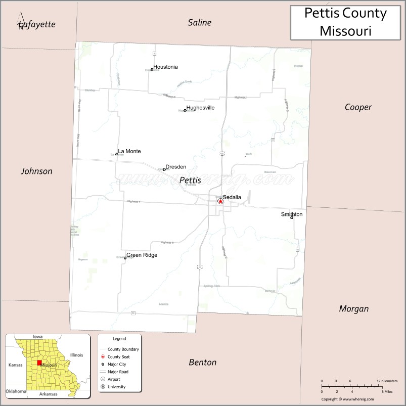
About Pettis County Map, Missouri: The map showing the county boundary, county seat, major cities, highways, water bodies and neighbouring counties.
Other Missouri Maps & Info
Pettis County, Missouri
Pettis County is a county located in the U.S. state of Missouri. It's county seat is Sedalia. As per 2020 census, the population of Pettis County is 43188 people and population density is square miles. According to the United States Census Bureau, the county has a total area of 685 sq mi (1,774 km2). Pettis County was established on 1833.
Pettis County Facts
| County Info | Facts |
|---|---|
| County | Pettis County |
| County Seat | Sedalia |
| State | Missouri |
| Country | United States |
| FIPS code | 159 |
| Established | 1833 |
| Area | 685 sq mi (1,774 km2) |
| Population | 43188 |
| Density | |
| Formed / Origin | Cooper and Saline counties |
Ctities in Pettis county
| City Name | Type | Population (2020) |
|---|---|---|
| Sedalia | 21,629 | |
| Green Ridge | City | 476 |
| Hughesville | Village | 183 |
| La Monte | City | 1,140 |
| Sedalia | City | 21,387 |
| Smithton | City | 570 |
- Adair County Map
- Andrew County Map
- Atchison County Map
- Audrain County Map
- Barry County Map
- Barton County Map
- Bates County Map
- Benton County Map
- Bollinger County Map
- Boone County Map
- Buchanan County Map
- Butler County Map
- Caldwell County Map
- Callaway County Map
- Camden County Map
- Cape Girardeau County Map
- Carroll County Map
- Carter County Map
- Cass County Map
- Cedar County Map
- Chariton County Map
- Christian County Map
- Clark County Map
- Clay County Map
- Clinton County Map
- Cole County Map
- Cooper County Map
- Crawford County Map
- Dade County Map
- Dallas County Map
- Daviess County Map
- DeKalb County Map
- Dent County Map
- Douglas County Map
- Dunklin County Map
- Franklin County Map
- Gasconade County Map
- Gentry County Map
- Greene County Map
- Grundy County Map
- Harrison County Map
- Henry County Map
- Hickory County Map
- Holt County Map
- Howard County Map
- Howell County Map
- Iron County Map
- Jackson County Map
- Jasper County Map
- Jefferson County Map
- Johnson County Map
- Knox County Map
- Laclede County Map
- Lafayette County Map
- Lawrence County Map
- Lewis County Map
- Lincoln County Map
- Linn County Map
- Livingston County Map
- McDonald County Map
- Macon County Map
- Madison County Map
- Maries County Map
- Marion County Map
- Mercer County Map
- Miller County Map
- Mississippi County Map
- Moniteau County Map
- Monroe County Map
- Montgomery County Map
- Morgan County Map
- New Madrid County Map
- Newton County Map
- Nodaway County Map
- Oregon County Map
- Osage County Map
- Ozark County Map
- Pemiscot County Map
- Perry County Map
- Pettis County Map
- Phelps County Map
- Pike County Map
- Platte County Map
- Polk County Map
- Pulaski County Map
- Putnam County Map
- Ralls County Map
- Randolph County Map
- Ray County Map
- Reynolds County Map
- Ripley County Map
- St Charles County Map
- St Clair County Map
- Ste Genevieve County Map
- St Francois County Map
- St Louis County Map
- Saline County Map
- Schuyler County Map
- Scotland County Map
- Scott County Map
- Shannon County Map
- Shelby County Map
- Stoddard County Map
- Stone County Map
- Sullivan County Map
- Taney County Map
- Texas County Map
- Vernon County Map
- Warren County Map
- Washington County Map
- Wayne County Map
- Webster County Map
- Worth County Map
- Wright County Map
- St Louis County Map
- Alabama Counties
- Alaska boroughs
- Arizona Counties
- Arkansas Counties
- California County Map
- Colorado Counties
- Connecticut Counties
- Delaware Counties
- Florida County Map
- Georgia County Map
- Hawaii Counties
- Idaho Counties
- Illinois Counties
- Indiana Counties
- Iowa Counties
- Kansas Counties
- Kentucky Counties
- Louisiana Counties
- Maine Counties
- Maryland Counties
- Massachusetts Counties
- Michigan County Map
- Minnesota Counties
- Mississippi Counties
- Missouri Counties
- Montana Counties
- Nebraska Counties
- New Hampshire Counties
- New Jersey Counties
- New Mexico Counties
- North Carolina Counties
- North Dakota Counties
- Oklahoma Counties
- Oregon Counties
- Pennsylvania Counties
- Rhode Island Counties
- South Carolina Counties
- South Dakota Counties
- Map of Tennessee
- Texas County Map
- Utah Counties
- Vermont Counties
- Virginia Counties
- Washington Counties
- West Virginia Counties
- Wisconsin Counties
- Wyoming Counties
- Nevada Counties
- New York Counties
- Ohio County Map