Map of Cole County - Cole County is a county located in the U.S. state of Missouri. Cole County Map showing cities, highways, important places and water bodies. Get Where is Cole County located in the map, major cities in Cole county, population, areas, and places of interest.
Map of Cole County, Missouri
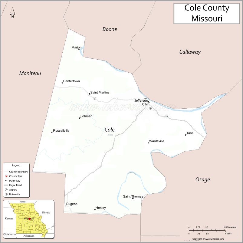
About Cole County Map, Missouri: The map showing the county boundary, county seat, major cities, highways, water bodies and neighbouring counties.
Related Missouri Maps & Info
Cole County, Missouri
Cole County is a county located in the U.S. state of Missouri. It's county seat is Jefferson City. As per 2020 census, the population of Cole County is 77205 people and population density is square miles. According to the United States Census Bureau, the county has a total area of 392 sq mi (1,015 km2). Cole County was established on 1820.
Cole County Facts
| Continent | North America |
| Country | United States |
| State | Missouri |
| County Seat | Jefferson City |
| Largest City/Town | Jefferson City |
| Established | 1820 |
| Total Area | 402 sq mi (1,041 sq km) |
| Land Area | 394 sq mi (1,020 sq km) |
| Water Area | 8 sq mi (21 sq km) |
| Population | 77,279 (Census 2020) |
| Population Density | 196.1 people per sq mi |
| Time Zone | Central Time Zone (CST/CDT) |
| Major Highways | U.S. Route 50, U.S. Route 54, U.S. Route 63, Missouri Route 179 |
| Major Rivers | Missouri River, Moreau River |
| Neighboring Counties | Callaway County, Osage County, Moniteau County, Miller County |
| Famous For | Missouri State Capitol, state government, Missouri River scenery, and historic Jefferson City |
| Top Attractions | Missouri State Capitol, Missouri State Museum, Runge Nature Center, and Katy Trail nearby region |
| Official Website | Official Website |
About Cole County
Cole County is located in central Missouri along the Missouri River and was established in 1820. The county seat and largest city is Jefferson City, which also serves as the capital of Missouri. The county is known for government institutions, historic architecture, riverfront scenery, and cultural attractions tied to Missouri history.
Cities and Towns in Cole County, Missouri
| City/Town | Population (Census 2020) | Latitude & Longitude |
|---|---|---|
| Jefferson City (county seat) | 43,228 | 38.5767°N, 92.1735°W |
| Russellville | 778 | 38.5111°N, 92.4402°W |
| St. Martins | 1,140 | 38.5961°N, 92.2149°W |
| Wardsville | 1,506 | 38.6970°N, 92.0824°W |
| Eugene | 2,593 | 38.3567°N, 92.3613°W |
| Taos | 1,220 | 38.5486°N, 92.1193°W |
What are the Golf Courses in Cole County
| Golf Course | Location | Latitude & Longitude |
|---|---|---|
| Jefferson City Country Club | Jefferson City | 38.5718°N, 92.2101°W |
| Eagle Knoll Golf Course | Hartsburg nearby region | 38.7002°N, 92.2757°W |
| Turkey Creek Golf Center | Jefferson City | 38.5847°N, 92.1650°W |
Major Roads and Highways in Cole County
Major highways connect the county with Missouri’s capital region and important transportation corridors across the state.
- U.S. Route 50 - major east-west highway across central Missouri
- U.S. Route 54 - important transportation corridor linking central Missouri communities
- U.S. Route 63 - north-south highway serving Jefferson City and regional areas
- Missouri Route 179 - scenic route through riverfront and countryside areas
What are Neighboring Counties of Cole County
- Callaway County (north)
- Moniteau County (northwest)
- Osage County (east and south)
- Miller County (west)
What Are the Top Attractions in Cole County
The county offers a mix of government landmarks, museums, outdoor recreation, and riverfront scenery.
- Missouri State Capitol - historic capitol building with murals, exhibits, and guided tours
- Missouri State Museum - exhibits covering state history, culture, and natural resources
- Runge Nature Center - wildlife exhibits, walking trails, and educational programs
- Katy Trail nearby region - biking and hiking trail along the Missouri River corridor
- Jefferson Landing State Historic Site - preserved riverfront district and transportation history
- Missouri State Penitentiary Tours - historic prison tours and architectural attractions
- Downtown Jefferson City - shops, restaurants, museums, and riverfront views
- Binder Park - sports facilities, trails, fishing lakes, and outdoor recreation
- Missouri River Scenic Drives - rolling hills, bluffs, and countryside landscapes
- Carnahan Memorial Garden - memorial park and scenic river overlook
What Is the Distance from Cole County to Nearby Cities
The following distances are measured by road (driving).
- Jefferson City to Columbia (Boone County), Missouri - 31 mi (50 km)
- Jefferson City to Saint Louis (St. Louis City), Missouri - 126 mi (203 km)
- Jefferson City to Kansas City (Jackson County), Missouri - 158 mi (254 km)
- Jefferson City to Fulton (Callaway County), Missouri - 27 mi (43 km)
- Jefferson City to Wardsville (Cole County), Missouri - 10 mi (16 km)
- Jefferson City to Lake Ozark (Miller County), Missouri - 47 mi (76 km)
- Jefferson City to Branson (Taney County), Missouri - 198 mi (319 km)
- Jefferson City to Tulsa (Tulsa County), Oklahoma - 297 mi (478 km)
- Jefferson City to Chicago (Cook County), Illinois - 394 mi (634 km)
- Jefferson City to Memphis (Shelby County), Tennessee - 339 mi (546 km)
- Jefferson City to Denver (Denver County), Colorado - 648 mi (1,043 km)
- Jefferson City to Minneapolis (Hennepin County), Minnesota - 535 mi (861 km)
FAQs about Cole County
Cole County is located in central Missouri along the Missouri River.
Cole County had a population of 77,279 according to the 2020 United States Census.
Cole County is known for the Missouri State Capitol, state government, and historic Jefferson City attractions.
The county is served by U.S. Route 50, U.S. Route 54, U.S. Route 63, and Missouri Route 179.
Yes, Cole County includes golf facilities such as Jefferson City Country Club, Eagle Knoll Golf Course, and Turkey Creek Golf Center.
References
- QuickFacts - U.S. Census Bureau
- United States Census Bureau
- United States Geological Survey (USGS)
- National Geodetic Survey
- Official Website
- Adair County Map
- Andrew County Map
- Atchison County Map
- Audrain County Map
- Barry County Map
- Barton County Map
- Bates County Map
- Benton County Map
- Bollinger County Map
- Boone County Map
- Buchanan County Map
- Butler County Map
- Caldwell County Map
- Callaway County Map
- Camden County Map
- Cape Girardeau County Map
- Carroll County Map
- Carter County Map
- Cass County Map
- Cedar County Map
- Chariton County Map
- Christian County Map
- Clark County Map
- Clay County Map
- Clinton County Map
- Cole County Map
- Cooper County Map
- Crawford County Map
- Dade County Map
- Dallas County Map
- Daviess County Map
- DeKalb County Map
- Dent County Map
- Douglas County Map
- Dunklin County Map
- Franklin County Map
- Gasconade County Map
- Gentry County Map
- Greene County Map
- Grundy County Map
- Harrison County Map
- Henry County Map
- Hickory County Map
- Holt County Map
- Howard County Map
- Howell County Map
- Iron County Map
- Jackson County Map
- Jasper County Map
- Jefferson County Map
- Johnson County Map
- Knox County Map
- Laclede County Map
- Lafayette County Map
- Lawrence County Map
- Lewis County Map
- Lincoln County Map
- Linn County Map
- Livingston County Map
- McDonald County Map
- Macon County Map
- Madison County Map
- Maries County Map
- Marion County Map
- Mercer County Map
- Miller County Map
- Mississippi County Map
- Moniteau County Map
- Monroe County Map
- Montgomery County Map
- Morgan County Map
- New Madrid County Map
- Newton County Map
- Nodaway County Map
- Oregon County Map
- Osage County Map
- Ozark County Map
- Pemiscot County Map
- Perry County Map
- Pettis County Map
- Phelps County Map
- Pike County Map
- Platte County Map
- Polk County Map
- Pulaski County Map
- Putnam County Map
- Ralls County Map
- Randolph County Map
- Ray County Map
- Reynolds County Map
- Ripley County Map
- St Charles County Map
- St Clair County Map
- Ste Genevieve County Map
- St Francois County Map
- St Louis County Map
- Saline County Map
- Schuyler County Map
- Scotland County Map
- Scott County Map
- Shannon County Map
- Shelby County Map
- Stoddard County Map
- Stone County Map
- Sullivan County Map
- Taney County Map
- Texas County Map
- Vernon County Map
- Warren County Map
- Washington County Map
- Wayne County Map
- Webster County Map
- Worth County Map
- Wright County Map
- St Louis County Map
- Alabama Counties
- Alaska boroughs
- Arizona Counties
- Arkansas Counties
- California County Map
- Colorado Counties
- Connecticut Counties
- Delaware Counties
- Florida County Map
- Georgia County Map
- Hawaii Counties
- Idaho Counties
- Illinois Counties
- Indiana Counties
- Iowa Counties
- Kansas Counties
- Kentucky Counties
- Louisiana Counties
- Maine Counties
- Maryland Counties
- Massachusetts Counties
- Michigan County Map
- Minnesota Counties
- Mississippi Counties
- Missouri Counties
- Montana Counties
- Nebraska Counties
- Nevada Counties
- New York Counties
- New Hampshire Counties
- New Jersey Counties
- New Mexico Counties
- North Carolina Counties
- North Dakota Counties
- Ohio County Map
- Oklahoma Counties
- Oregon Counties
- Pennsylvania Counties
- Rhode Island Counties
- South Carolina Counties
- South Dakota Counties
- Map of Tennessee
- Texas County Map
- Utah Counties
- Vermont Counties
- Virginia Counties
- Washington Counties
- West Virginia Counties
- Wisconsin Counties
- Wyoming Counties