Map of Sainte Genevieve County - Sainte Genevieve County is a county located in the U.S. state of Missouri. Sainte Genevieve County Map showing cities, highways, important places and water bodies. Get Where is Sainte Genevieve County located in the map, major cities in Sainte Genevieve county, population, areas, and places of interest.
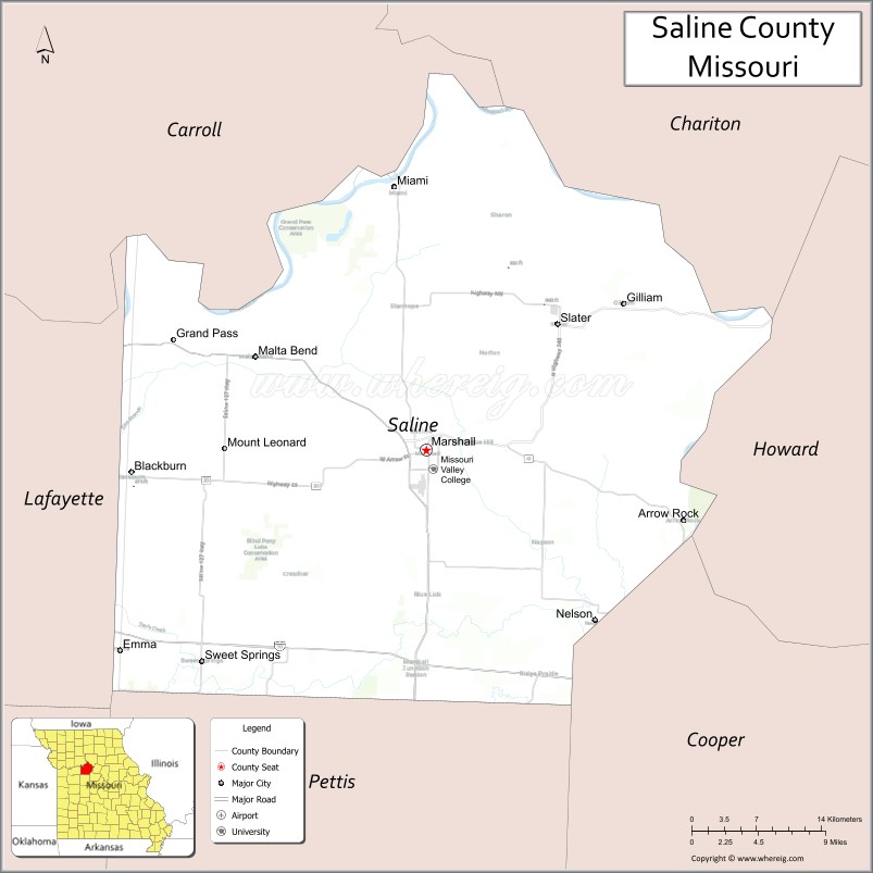
Map of Saline County, Missouri
About Sainte Genevieve County Map, Missouri: The map showing the county boundary, county seat, major cities, highways, water bodies and neighbouring counties.
Related Missouri Maps & Info
Saline County, Missouri
Saline County is a county located in the U.S. state of Missouri. It's county seat is Marshall. As per 2020 census, the population of Saline County is 23289 people and population density is square miles. According to the United States Census Bureau, the county has a total area of 756 sq mi (1,958 km2). Saline County was established on 1820.
Saline County Facts
| Continent | North America |
| Country | United States |
| State | Missouri |
| County Seat | Marshall |
| Largest City/Town | Marshall |
| Established | 1820 |
| Total Area | 767 sq mi (1,986 sq km) |
| Land Area | 756 sq mi (1,958 sq km) |
| Water Area | 11 sq mi (28 sq km) |
| Population | 22,921 (Census 2020) |
| Population Density | 30.3 people per sq mi |
| Time Zone | Central Time Zone (CST/CDT) |
| Major Highways | Interstate 70, U.S. Route 65, U.S. Route 240, Missouri Route 41 |
| Major Rivers | Missouri River nearby region, Blackwater River |
| Neighboring Counties | Lafayette County, Carroll County, Pettis County, Chariton County, Cooper County |
| Famous For | Agriculture, Missouri Valley College, historic Marshall, and central Missouri prairie landscapes |
| Top Attractions | Missouri Valley College, Arrow Rock nearby region, Nicholas Beazley Aviation Museum, and Van Meter State Park nearby region |
| Official Website | Official Website |
About Saline County
Saline County is located in central Missouri along the historic Missouri River corridor and was established in 1820. The county seat and largest city is Marshall. The county is known for agriculture, educational institutions, prairie scenery, and rich Missouri frontier history.
Cities and Towns in Saline County, Missouri
| City/Town | Population (Census 2020) | Latitude & Longitude |
|---|---|---|
| Marshall (county seat) | 13,476 | 39.1231°N, 93.1960°W |
| Slater | 1,856 | 39.2184°N, 93.0688°W |
| Sweet Springs | 1,484 | 38.9642°N, 93.4141°W |
| Blackburn | 249 | 39.1064°N, 93.1274°W |
| Gilliam | 197 | 39.2245°N, 92.9816°W |
| Nelson | 154 | 39.1687°N, 92.9964°W |
What are the Golf Courses in Saline County
| Golf Course | Location | Latitude & Longitude |
|---|---|---|
| Indian Foothills Golf Course | Marshall | 39.1338°N, 93.2075°W |
| Marshall Country Club | Marshall | 39.1189°N, 93.1826°W |
| Sweet Springs Recreation Golf Area | Sweet Springs | 38.9728°N, 93.4267°W |
Major Roads and Highways in Saline County
Major highways connect Saline County with Kansas City, Columbia, and central Missouri communities.
- Interstate 70 - major east-west interstate corridor across Missouri
- U.S. Route 65 - important north-south transportation route through central Missouri
- U.S. Route 240 - regional route linking historic river communities
- Missouri Route 41 - connector highway serving agricultural and rural areas
What are Neighboring Counties of Saline County
- Chariton County (north)
- Cooper County (south)
- Pettis County (southwest)
- Lafayette County (west)
- Carroll County (northwest)
What Are the Top Attractions in Saline County
The county offers historic attractions, educational sites, outdoor recreation, and prairie landscapes.
- Missouri Valley College - historic campus, athletics, and cultural events
- Nicholas Beazley Aviation Museum - aviation history exhibits and aircraft displays
- Arrow Rock nearby region - historic village and Missouri River heritage attractions
- Van Meter State Park nearby region - hiking trails, Native American history, and camping
- Historic Downtown Marshall - shops, restaurants, and preserved architecture
- Blackwater River Recreation Areas - fishing, kayaking, and nature observation
- Community Festivals and County Fair Events - seasonal entertainment and agricultural traditions
- Prairie Scenic Drives - rolling farmland and countryside photography opportunities
- Hunting and Wildlife Areas - birdwatching and outdoor recreation
- Parks and Picnic Areas - family-friendly recreation and relaxation spaces
What Is the Distance from Saline County to Nearby Cities
The following distances are measured by road (driving).
- Marshall to Columbia (Boone County), Missouri - 55 mi (89 km)
- Marshall to Kansas City (Jackson County), Missouri - 89 mi (143 km)
- Marshall to Jefferson City (Cole County), Missouri - 76 mi (122 km)
- Marshall to Sedalia (Pettis County), Missouri - 31 mi (50 km)
- Marshall to Slater (Saline County), Missouri - 15 mi (24 km)
- Marshall to Sweet Springs (Saline County), Missouri - 18 mi (29 km)
- Marshall to St. Louis (St. Louis City), Missouri - 187 mi (301 km)
- Marshall to Springfield (Greene County), Missouri - 172 mi (277 km)
- Marshall to Omaha (Douglas County), Nebraska - 267 mi (430 km)
- Marshall to Chicago (Cook County), Illinois - 442 mi (711 km)
- Marshall to Dallas (Dallas County), Texas - 497 mi (800 km)
- Marshall to Denver (Denver County), Colorado - 610 mi (982 km)
- Marshall to Minneapolis (Hennepin County), Minnesota - 505 mi (813 km)
FAQs about Saline County
Saline County is located in central Missouri along the Missouri River corridor.
Saline County had a population of 22,921 according to the 2020 United States Census.
Saline County is known for agriculture, Missouri Valley College, and historic prairie communities.
The county is served by Interstate 70, U.S. Route 65, U.S. Route 240, and Missouri Route 41.
Yes, Saline County includes golf facilities such as Indian Foothills Golf Course and Marshall Country Club.
References
- QuickFacts - U.S. Census Bureau
- United States Census Bureau
- United States Geological Survey (USGS)
- National Geodetic Survey
- Official Website
- Adair County Map
- Andrew County Map
- Atchison County Map
- Audrain County Map
- Barry County Map
- Barton County Map
- Bates County Map
- Benton County Map
- Bollinger County Map
- Boone County Map
- Buchanan County Map
- Butler County Map
- Caldwell County Map
- Callaway County Map
- Camden County Map
- Cape Girardeau County Map
- Carroll County Map
- Carter County Map
- Cass County Map
- Cedar County Map
- Chariton County Map
- Christian County Map
- Clark County Map
- Clay County Map
- Clinton County Map
- Cole County Map
- Cooper County Map
- Crawford County Map
- Dade County Map
- Dallas County Map
- Daviess County Map
- DeKalb County Map
- Dent County Map
- Douglas County Map
- Dunklin County Map
- Franklin County Map
- Gasconade County Map
- Gentry County Map
- Greene County Map
- Grundy County Map
- Harrison County Map
- Henry County Map
- Hickory County Map
- Holt County Map
- Howard County Map
- Howell County Map
- Iron County Map
- Jackson County Map
- Jasper County Map
- Jefferson County Map
- Johnson County Map
- Knox County Map
- Laclede County Map
- Lafayette County Map
- Lawrence County Map
- Lewis County Map
- Lincoln County Map
- Linn County Map
- Livingston County Map
- McDonald County Map
- Macon County Map
- Madison County Map
- Maries County Map
- Marion County Map
- Mercer County Map
- Miller County Map
- Mississippi County Map
- Moniteau County Map
- Monroe County Map
- Montgomery County Map
- Morgan County Map
- New Madrid County Map
- Newton County Map
- Nodaway County Map
- Oregon County Map
- Osage County Map
- Ozark County Map
- Pemiscot County Map
- Perry County Map
- Pettis County Map
- Phelps County Map
- Pike County Map
- Platte County Map
- Polk County Map
- Pulaski County Map
- Putnam County Map
- Ralls County Map
- Randolph County Map
- Ray County Map
- Reynolds County Map
- Ripley County Map
- St Charles County Map
- St Clair County Map
- Ste Genevieve County Map
- St Francois County Map
- St Louis County Map
- Saline County Map
- Schuyler County Map
- Scotland County Map
- Scott County Map
- Shannon County Map
- Shelby County Map
- Stoddard County Map
- Stone County Map
- Sullivan County Map
- Taney County Map
- Texas County Map
- Vernon County Map
- Warren County Map
- Washington County Map
- Wayne County Map
- Webster County Map
- Worth County Map
- Wright County Map
- St Louis County Map
- Alabama Counties
- Alaska boroughs
- Arizona Counties
- Arkansas Counties
- California County Map
- Colorado Counties
- Connecticut Counties
- Delaware Counties
- Florida County Map
- Georgia County Map
- Hawaii Counties
- Idaho Counties
- Illinois Counties
- Indiana Counties
- Iowa Counties
- Kansas Counties
- Kentucky Counties
- Louisiana Counties
- Maine Counties
- Maryland Counties
- Massachusetts Counties
- Michigan County Map
- Minnesota Counties
- Mississippi Counties
- Missouri Counties
- Montana Counties
- Nebraska Counties
- Nevada Counties
- New York Counties
- New Hampshire Counties
- New Jersey Counties
- New Mexico Counties
- North Carolina Counties
- North Dakota Counties
- Ohio County Map
- Oklahoma Counties
- Oregon Counties
- Pennsylvania Counties
- Rhode Island Counties
- South Carolina Counties
- South Dakota Counties
- Map of Tennessee
- Texas County Map
- Utah Counties
- Vermont Counties
- Virginia Counties
- Washington Counties
- West Virginia Counties
- Wisconsin Counties
- Wyoming Counties