Map of Adair County - Adair County is a county located in the U.S. state of Missouri. Adair County Map showing cities, highways, important places and water bodies. Get Where is Adair County located in the map, major cities in Adair county, population, areas, and places of interest.
Map of Adair County, Missouri
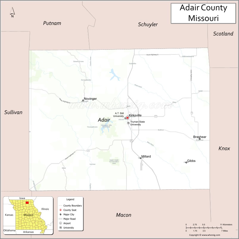
About Adair County Map, Missouri: The map showing the county boundary, county seat, major cities, highways, water bodies and neighbouring counties.
Related Missouri Maps & Info
Adair County, Missouri
Adair County is a county located in the U.S. state of Missouri. It's county seat is Kirksville. As per 2020 census, the population of Adair County is 25185 people and population density is square miles. According to the United States Census Bureau, the county has a total area of 568 sq mi (1,471 km2). Adair County was established on 1841.
Adair County Facts
| Continent | North America |
| Country | United States |
| State | Missouri |
| County Seat | Kirksville |
| Largest City/Town | Kirksville |
| Established | 1841 |
| Total Area | 569 sq mi (1,474 sq km) |
| Land Area | 567 sq mi (1,468 sq km) |
| Water Area | 2 sq mi (5 sq km) |
| Population | 25,314 (Census 2020) |
| Population Density | 44.6 people per sq mi |
| Time Zone | Central Time Zone (CST/CDT) |
| Major Highways | U.S. Route 63, U.S. Route 36, Missouri Route 6 |
| Major Rivers | Chariton River, Salt River nearby region |
| Neighboring Counties | Schuyler County, Knox County, Macon County, Sullivan County, Putnam County |
| Famous For | Truman State University, healthcare education, northeast Missouri culture, and rural landscapes |
| Top Attractions | Truman State University campus, Thousand Hills State Park, Museum of Osteopathic Medicine, and downtown Kirksville |
| Official Website | Official Website |
About Adair County
Adair County is located in northeastern Missouri in the central United States and was established in 1841. The county seat and largest city is Kirksville. The county is known for higher education institutions, medical training programs, scenic rural landscapes, and cultural attractions in northeast Missouri.
Cities and Towns in Adair County, Missouri
| City/Town | Population (Census 2020) | Latitude & Longitude |
|---|---|---|
| Kirksville (county seat) | 17,530 | 40.1948°N, 92.5833°W |
| Novinger | 456 | 40.2334°N, 92.7066°W |
| Brashear | 267 | 40.1945°N, 92.3971°W |
| Greentop | 248 | 40.3492°N, 92.5710°W |
| Millard | 91 | 40.1636°N, 92.3215°W |
| Connelsville | 44 | 40.2840°N, 92.6108°W |
What are the Golf Courses in Adair County
| Golf Course | Location | Latitude & Longitude |
|---|---|---|
| Kirksville Country Club | Kirksville | 40.2029°N, 92.5904°W |
| Thousand Hills Golf Recreation Area | Kirksville | 40.1643°N, 92.6237°W |
Major Roads and Highways in Adair County
Major highways connect the county with northeast Missouri communities and regional education centers.
- U.S. Route 63 - major north-south highway through northeastern Missouri
- U.S. Route 36 - important east-west transportation corridor
- Missouri Route 6 - regional route linking local communities
What are Neighboring Counties of Adair County
- Putnam County (north)
- Schuyler County (east)
- Knox County (southeast)
- Macon County (south)
- Sullivan County (west)
What Are the Top Attractions in Adair County
The county offers a mix of educational landmarks, outdoor recreation, and cultural attractions.
- Truman State University Campus - historic university with cultural events and academic landmarks
- Thousand Hills State Park - hiking, boating, camping, and forest recreation area
- Museum of Osteopathic Medicine - exhibits on medical education and osteopathic history
- Downtown Kirksville - restaurants, shops, and historic architecture
- Forest Lake Recreation Area - fishing, kayaking, and picnic destinations
- Northeast Missouri Rural Scenic Drives - countryside routes through farmland and rolling hills
- Kirksville Arts and Cultural Events - festivals, theater performances, and university activities
- Adair County Historical Society Museum - local history exhibits and pioneer artifacts
- Chariton River Valley Landscapes - wildlife viewing and outdoor photography opportunities
- Novinger Coal Mining Heritage Sites - historical attractions tied to early mining communities
What Is the Distance from Adair County to Nearby Cities
The following distances are measured by road (driving).
- Kirksville to Columbia (Boone County), Missouri - 108 mi (174 km)
- Kirksville to Quincy (Adams County), Illinois - 91 mi (146 km)
- Kirksville to Hannibal (Marion County), Missouri - 86 mi (138 km)
- Kirksville to Macon (Macon County), Missouri - 31 mi (50 km)
- Kirksville to Novinger (Adair County), Missouri - 10 mi (16 km)
- Kirksville to Greentop (Adair County), Missouri - 12 mi (19 km)
- Kirksville to Des Moines (Polk County), Iowa - 174 mi (280 km)
- Kirksville to Kansas City (Jackson County), Missouri - 190 mi (306 km)
- Kirksville to Saint Louis (St. Louis City), Missouri - 210 mi (338 km)
- Kirksville to Springfield (Greene County), Missouri - 232 mi (373 km)
- Kirksville to Chicago (Cook County), Illinois - 340 mi (547 km)
- Kirksville to Minneapolis (Hennepin County), Minnesota - 430 mi (692 km)
- Kirksville to Denver (Denver County), Colorado - 720 mi (1,159 km)
FAQs about Adair County
Adair County is located in northeastern Missouri in the United States.
Adair County had a population of 25,314 according to the 2020 United States Census.
Adair County is known for Truman State University, medical education, rural scenery, and cultural attractions.
The county is served by U.S. Route 63, U.S. Route 36, and Missouri Route 6.
Yes, Adair County includes golf facilities such as Kirksville Country Club and Thousand Hills Golf Recreation Area.
References
- QuickFacts - U.S. Census Bureau
- United States Census Bureau
- United States Geological Survey (USGS)
- National Geodetic Survey
- Official Website
- Adair County Map
- Andrew County Map
- Atchison County Map
- Audrain County Map
- Barry County Map
- Barton County Map
- Bates County Map
- Benton County Map
- Bollinger County Map
- Boone County Map
- Buchanan County Map
- Butler County Map
- Caldwell County Map
- Callaway County Map
- Camden County Map
- Cape Girardeau County Map
- Carroll County Map
- Carter County Map
- Cass County Map
- Cedar County Map
- Chariton County Map
- Christian County Map
- Clark County Map
- Clay County Map
- Clinton County Map
- Cole County Map
- Cooper County Map
- Crawford County Map
- Dade County Map
- Dallas County Map
- Daviess County Map
- DeKalb County Map
- Dent County Map
- Douglas County Map
- Dunklin County Map
- Franklin County Map
- Gasconade County Map
- Gentry County Map
- Greene County Map
- Grundy County Map
- Harrison County Map
- Henry County Map
- Hickory County Map
- Holt County Map
- Howard County Map
- Howell County Map
- Iron County Map
- Jackson County Map
- Jasper County Map
- Jefferson County Map
- Johnson County Map
- Knox County Map
- Laclede County Map
- Lafayette County Map
- Lawrence County Map
- Lewis County Map
- Lincoln County Map
- Linn County Map
- Livingston County Map
- McDonald County Map
- Macon County Map
- Madison County Map
- Maries County Map
- Marion County Map
- Mercer County Map
- Miller County Map
- Mississippi County Map
- Moniteau County Map
- Monroe County Map
- Montgomery County Map
- Morgan County Map
- New Madrid County Map
- Newton County Map
- Nodaway County Map
- Oregon County Map
- Osage County Map
- Ozark County Map
- Pemiscot County Map
- Perry County Map
- Pettis County Map
- Phelps County Map
- Pike County Map
- Platte County Map
- Polk County Map
- Pulaski County Map
- Putnam County Map
- Ralls County Map
- Randolph County Map
- Ray County Map
- Reynolds County Map
- Ripley County Map
- St Charles County Map
- St Clair County Map
- Ste Genevieve County Map
- St Francois County Map
- St Louis County Map
- Saline County Map
- Schuyler County Map
- Scotland County Map
- Scott County Map
- Shannon County Map
- Shelby County Map
- Stoddard County Map
- Stone County Map
- Sullivan County Map
- Taney County Map
- Texas County Map
- Vernon County Map
- Warren County Map
- Washington County Map
- Wayne County Map
- Webster County Map
- Worth County Map
- Wright County Map
- St Louis County Map
- Alabama Counties
- Alaska boroughs
- Arizona Counties
- Arkansas Counties
- California County Map
- Colorado Counties
- Connecticut Counties
- Delaware Counties
- Florida County Map
- Georgia County Map
- Hawaii Counties
- Idaho Counties
- Illinois Counties
- Indiana Counties
- Iowa Counties
- Kansas Counties
- Kentucky Counties
- Louisiana Counties
- Maine Counties
- Maryland Counties
- Massachusetts Counties
- Michigan County Map
- Minnesota Counties
- Mississippi Counties
- Missouri Counties
- Montana Counties
- Nebraska Counties
- Nevada Counties
- New York Counties
- New Hampshire Counties
- New Jersey Counties
- New Mexico Counties
- North Carolina Counties
- North Dakota Counties
- Ohio County Map
- Oklahoma Counties
- Oregon Counties
- Pennsylvania Counties
- Rhode Island Counties
- South Carolina Counties
- South Dakota Counties
- Map of Tennessee
- Texas County Map
- Utah Counties
- Vermont Counties
- Virginia Counties
- Washington Counties
- West Virginia Counties
- Wisconsin Counties
- Wyoming Counties