Map of Callaway County - Callaway County is a county located in the U.S. state of Missouri. Callaway County Map showing cities, highways, important places and water bodies. Get Where is Callaway County located in the map, major cities in Callaway county, population, areas, and places of interest.
Map of Callaway County, Missouri
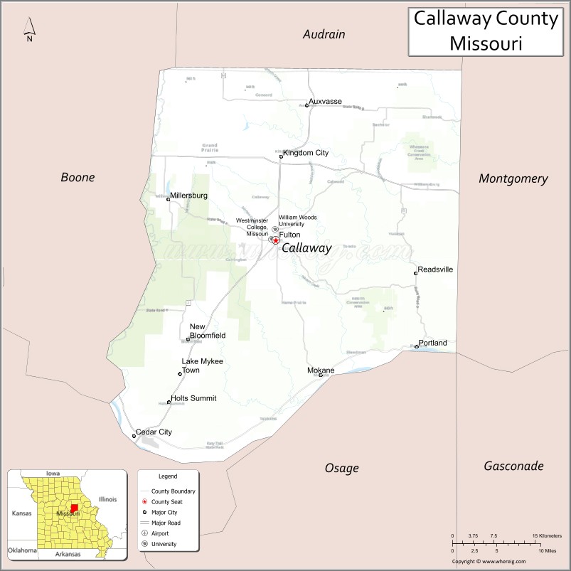
About Callaway County Map, Missouri: The map showing the county boundary, county seat, major cities, highways, water bodies and neighbouring counties.
Related Missouri Maps & Info
Callaway County, Missouri
Callaway County is a county located in the U.S. state of Missouri. It's county seat is Fulton. As per 2020 census, the population of Callaway County is 44638 people and population density is square miles. According to the United States Census Bureau, the county has a total area of 839 sq mi (2,173 km2). Callaway County was established on 1821.
Callaway County Facts
| Continent | North America |
| Country | United States |
| State | Missouri |
| County Seat | Fulton |
| Largest City/Town | Fulton |
| Established | 1820 |
| Total Area | 847 sq mi (2,194 sq km) |
| Land Area | 835 sq mi (2,163 sq km) |
| Water Area | 12 sq mi (31 sq km) |
| Population | 44,283 (Census 2020) |
| Population Density | 53.0 people per sq mi |
| Time Zone | Central Time Zone (CST/CDT) |
| Major Highways | Interstate 70, U.S. Route 54, Missouri Route 94 |
| Major Rivers | Missouri River, Auxvasse Creek |
| Neighboring Counties | Montgomery County, Audrain County, Boone County, Cole County, Osage County, Gasconade County |
| Famous For | Westminster College, Winston Churchill's Iron Curtain speech, Missouri River history, and wineries |
| Top Attractions | National Churchill Museum, Westminster College, Katy Trail nearby region, and downtown Fulton |
| Official Website | Official Website |
About Callaway County
Callaway County is located in central Missouri in the United States and was established in 1820. The county seat and largest city is Fulton. The county is known for higher education, historic landmarks, Missouri River heritage, scenic countryside, and the famous Iron Curtain speech delivered by Winston Churchill at Westminster College.
Cities and Towns in Callaway County, Missouri
| City/Town | Population (Census 2020) | Latitude & Longitude |
|---|---|---|
| Fulton (county seat) | 12,848 | 38.8467°N, 91.9479°W |
| Holts Summit | 3,899 | 38.6406°N, 92.1224°W |
| Kingdom City | 128 | 38.9517°N, 91.9399°W |
| Auxvasse | 983 | 39.0164°N, 91.8974°W |
| Mokane | 173 | 38.6745°N, 91.8780°W |
| Steedman | 45 | 38.7598°N, 91.8185°W |
What are the Golf Courses in Callaway County
| Golf Course | Location | Latitude & Longitude |
|---|---|---|
| Tanglewood Golf Course | Fulton | 38.8561°N, 91.9592°W |
| Railwood Golf Club | Holts Summit | 38.6538°N, 92.1115°W |
Major Roads and Highways in Callaway County
Major highways connect the county with central Missouri cities and transportation corridors.
- Interstate 70 - major east-west interstate through central Missouri
- U.S. Route 54 - important north-south transportation route
- Missouri Route 94 - scenic route following portions of the Missouri River Valley
What are Neighboring Counties of Callaway County
- Audrain County (north)
- Montgomery County (northeast)
- Gasconade County (southeast)
- Osage County (south)
- Cole County (southwest)
- Boone County (west)
What Are the Top Attractions in Callaway County
The county offers a mix of educational landmarks, historic sites, wineries, and outdoor recreation.
- National Churchill Museum - museum featuring exhibits about Winston Churchill and world history
- Westminster College - historic campus known for Churchill’s Iron Curtain speech
- Katy Trail nearby region - popular biking and hiking trail along the Missouri River
- Downtown Fulton - restaurants, shopping, and preserved historic architecture
- Missouri River Wine Country - wineries and scenic countryside along the river valley
- Auto World Museum - collection of vintage automobiles and transportation exhibits
- Kingdom of Callaway Historical Sites - attractions tied to Civil War and regional history
- Little Dixie Lake Conservation Area - fishing, boating, and hiking opportunities
- Holts Summit Recreation Areas - parks, sports facilities, and community events
- Missouri River Scenic Drives - rolling hills, farmland, and river valley views
What Is the Distance from Callaway County to Nearby Cities
The following distances are measured by road (driving).
- Fulton to Columbia (Boone County), Missouri - 26 mi (42 km)
- Fulton to Jefferson City (Cole County), Missouri - 27 mi (43 km)
- Fulton to Saint Louis (St. Louis City), Missouri - 105 mi (169 km)
- Fulton to Kansas City (Jackson County), Missouri - 150 mi (241 km)
- Fulton to Holts Summit (Callaway County), Missouri - 13 mi (21 km)
- Fulton to Auxvasse (Callaway County), Missouri - 13 mi (21 km)
- Fulton to Springfield (Greene County), Missouri - 170 mi (274 km)
- Fulton to Quincy (Adams County), Illinois - 123 mi (198 km)
- Fulton to Chicago (Cook County), Illinois - 330 mi (531 km)
- Fulton to Memphis (Shelby County), Tennessee - 348 mi (560 km)
- Fulton to Minneapolis (Hennepin County), Minnesota - 511 mi (822 km)
- Fulton to Denver (Denver County), Colorado - 642 mi (1,033 km)
- Fulton to Nashville (Davidson County), Tennessee - 382 mi (615 km)
FAQs about Callaway County
Callaway County is located in central Missouri along the Missouri River region.
Callaway County had a population of 44,283 according to the 2020 United States Census.
Callaway County is known for Westminster College, the Iron Curtain speech, wineries, and Missouri River history.
The county is served by Interstate 70, U.S. Route 54, and Missouri Route 94.
Yes, Callaway County includes golf facilities such as Tanglewood Golf Course and Railwood Golf Club.
References
- QuickFacts - U.S. Census Bureau
- United States Census Bureau
- United States Geological Survey (USGS)
- National Geodetic Survey
- Official Website
- Adair County Map
- Andrew County Map
- Atchison County Map
- Audrain County Map
- Barry County Map
- Barton County Map
- Bates County Map
- Benton County Map
- Bollinger County Map
- Boone County Map
- Buchanan County Map
- Butler County Map
- Caldwell County Map
- Callaway County Map
- Camden County Map
- Cape Girardeau County Map
- Carroll County Map
- Carter County Map
- Cass County Map
- Cedar County Map
- Chariton County Map
- Christian County Map
- Clark County Map
- Clay County Map
- Clinton County Map
- Cole County Map
- Cooper County Map
- Crawford County Map
- Dade County Map
- Dallas County Map
- Daviess County Map
- DeKalb County Map
- Dent County Map
- Douglas County Map
- Dunklin County Map
- Franklin County Map
- Gasconade County Map
- Gentry County Map
- Greene County Map
- Grundy County Map
- Harrison County Map
- Henry County Map
- Hickory County Map
- Holt County Map
- Howard County Map
- Howell County Map
- Iron County Map
- Jackson County Map
- Jasper County Map
- Jefferson County Map
- Johnson County Map
- Knox County Map
- Laclede County Map
- Lafayette County Map
- Lawrence County Map
- Lewis County Map
- Lincoln County Map
- Linn County Map
- Livingston County Map
- McDonald County Map
- Macon County Map
- Madison County Map
- Maries County Map
- Marion County Map
- Mercer County Map
- Miller County Map
- Mississippi County Map
- Moniteau County Map
- Monroe County Map
- Montgomery County Map
- Morgan County Map
- New Madrid County Map
- Newton County Map
- Nodaway County Map
- Oregon County Map
- Osage County Map
- Ozark County Map
- Pemiscot County Map
- Perry County Map
- Pettis County Map
- Phelps County Map
- Pike County Map
- Platte County Map
- Polk County Map
- Pulaski County Map
- Putnam County Map
- Ralls County Map
- Randolph County Map
- Ray County Map
- Reynolds County Map
- Ripley County Map
- St Charles County Map
- St Clair County Map
- Ste Genevieve County Map
- St Francois County Map
- St Louis County Map
- Saline County Map
- Schuyler County Map
- Scotland County Map
- Scott County Map
- Shannon County Map
- Shelby County Map
- Stoddard County Map
- Stone County Map
- Sullivan County Map
- Taney County Map
- Texas County Map
- Vernon County Map
- Warren County Map
- Washington County Map
- Wayne County Map
- Webster County Map
- Worth County Map
- Wright County Map
- St Louis County Map
- Alabama Counties
- Alaska boroughs
- Arizona Counties
- Arkansas Counties
- California County Map
- Colorado Counties
- Connecticut Counties
- Delaware Counties
- Florida County Map
- Georgia County Map
- Hawaii Counties
- Idaho Counties
- Illinois Counties
- Indiana Counties
- Iowa Counties
- Kansas Counties
- Kentucky Counties
- Louisiana Counties
- Maine Counties
- Maryland Counties
- Massachusetts Counties
- Michigan County Map
- Minnesota Counties
- Mississippi Counties
- Missouri Counties
- Montana Counties
- Nebraska Counties
- Nevada Counties
- New York Counties
- New Hampshire Counties
- New Jersey Counties
- New Mexico Counties
- North Carolina Counties
- North Dakota Counties
- Ohio County Map
- Oklahoma Counties
- Oregon Counties
- Pennsylvania Counties
- Rhode Island Counties
- South Carolina Counties
- South Dakota Counties
- Map of Tennessee
- Texas County Map
- Utah Counties
- Vermont Counties
- Virginia Counties
- Washington Counties
- West Virginia Counties
- Wisconsin Counties
- Wyoming Counties