Map of Platte County - Platte County is a county located in the U.S. state of Missouri. Platte County Map showing cities, highways, important places and water bodies. Get Where is Platte County located in the map, major cities in Platte county, population, areas, and places of interest.
Map of Platte County, Missouri
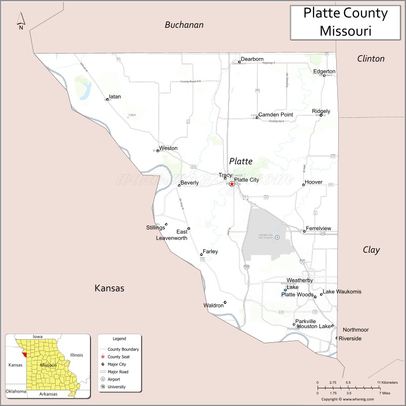
About Platte County Map, Missouri: The map showing the county boundary, county seat, major cities, highways, water bodies and neighbouring counties.
Related Missouri Maps & Info
Platte County, Missouri
Platte County is a county located in the U.S. state of Missouri. It's county seat is Platte City. As per 2020 census, the population of Platte County is 108569 people and population density is square miles. According to the United States Census Bureau, the county has a total area of 420 sq mi (1,088 km2). Platte County was established on 1838.
Platte County Facts
| Continent | North America |
| Country | United States |
| State | Missouri |
| County Seat | Platte City |
| Largest City/Town | Kansas City (partly) |
| Established | 1838 |
| Total Area | 427 sq mi (1,106 sq km) |
| Land Area | 420 sq mi (1,088 sq km) |
| Water Area | 7 sq mi (18 sq km) |
| Population | 106,718 (Census 2020) |
| Population Density | 254.1 people per sq mi |
| Time Zone | Central Time Zone (CST/CDT) |
| Major Highways | Interstate 29, Interstate 435, Interstate 635, U.S. Route 71 nearby region |
| Major Rivers | Missouri River, Platte River |
| Neighboring Counties | Clay County, Buchanan County, Clinton County, Leavenworth County (Kansas), Wyandotte County (Kansas) |
| Famous For | Kansas City International Airport, suburban growth, parks, and Missouri River history |
| Top Attractions | Weston historic district, Zona Rosa shopping district, Platte Falls Conservation Area, and KCI Airport region |
| Official Website | Official Website |
About Platte County
Platte County is located in northwestern Missouri within the Kansas City metropolitan area and was established in 1838. The county seat is Platte City, while part of Kansas City is the largest urban area in the county. Platte County is known for suburban development, transportation hubs, historic river towns, and scenic Missouri River landscapes.
Cities and Towns in Platte County, Missouri
| City/Town | Population (Census 2020) | Latitude & Longitude |
|---|---|---|
| Platte City (county seat) | 4,784 | 39.3703°N, 94.7822°W |
| Kansas City (partly) | 508,090 (citywide) | 39.0997°N, 94.5786°W |
| Parkville | 7,177 | 39.1950°N, 94.6819°W |
| Riverside | 4,013 | 39.1733°N, 94.6133°W |
| Weston | 1,641 | 39.4111°N, 94.9014°W |
| Weatherby Lake | 1,756 | 39.2469°N, 94.6916°W |
What are the Golf Courses in Platte County
| Golf Course | Location | Latitude & Longitude |
|---|---|---|
| The National Golf Club of Kansas City | Parkville | 39.2114°N, 94.7087°W |
| Shiloh Springs Golf Club | Platte City | 39.3815°N, 94.7961°W |
| Riverside Red X Golf Course | Riverside | 39.1828°N, 94.6210°W |
Major Roads and Highways in Platte County
Major highways connect Platte County with Kansas City, Kansas, Nebraska, and the Midwest transportation network.
- Interstate 29 - major north-south interstate connecting Kansas City with Iowa and Nebraska
- Interstate 435 - beltway route around the Kansas City metropolitan area
- Interstate 635 - connector interstate linking Missouri and Kansas suburbs
- U.S. Route 71 nearby region - regional transportation route through western Missouri
What are Neighboring Counties of Platte County
- Clay County (east)
- Clinton County (north)
- Buchanan County (northwest)
- Leavenworth County, Kansas (west)
- Wyandotte County, Kansas (southwest)
What Are the Top Attractions in Platte County
The county offers historic attractions, shopping districts, parks, and Kansas City metropolitan entertainment.
- Historic Weston - preserved 19th-century architecture, wineries, and boutique shops
- Zona Rosa Shopping District - retail stores, restaurants, and entertainment venues
- Platte Falls Conservation Area - hiking, fishing, and nature observation
- Kansas City International Airport Region - transportation hub and nearby attractions
- Parkville Riverfront - Missouri River scenery, trails, and historic downtown district
- Weston Bend State Park - scenic overlooks, hiking trails, and river valley views
- Weatherby Lake Recreation Areas - boating, fishing, and lakeside activities
- Community Festivals and Cultural Events - local fairs, concerts, and seasonal celebrations
- Missouri River Scenic Drives - countryside and river bluff photography opportunities
- Outdoor Parks and Recreation Facilities - sports, picnics, and family-friendly activities
What Is the Distance from Platte County to Nearby Cities
The following distances are measured by road (driving).
- Platte City to Kansas City (Jackson County), Missouri - 28 mi (45 km)
- Platte City to St. Joseph (Buchanan County), Missouri - 38 mi (61 km)
- Platte City to Lawrence (Douglas County), Kansas - 56 mi (90 km)
- Platte City to Topeka (Shawnee County), Kansas - 82 mi (132 km)
- Platte City to Parkville (Platte County), Missouri - 16 mi (26 km)
- Platte City to Weston (Platte County), Missouri - 14 mi (23 km)
- Platte City to Columbia (Boone County), Missouri - 135 mi (217 km)
- Platte City to Springfield (Greene County), Missouri - 205 mi (330 km)
- Platte City to St. Louis (St. Louis City), Missouri - 266 mi (428 km)
- Platte City to Omaha (Douglas County), Nebraska - 183 mi (295 km)
- Platte City to Chicago (Cook County), Illinois - 515 mi (829 km)
- Platte City to Dallas (Dallas County), Texas - 537 mi (864 km)
- Platte City to Denver (Denver County), Colorado - 602 mi (969 km)
FAQs about Platte County
Platte County is located in northwestern Missouri within the Kansas City metropolitan area.
Platte County had a population of 106,718 according to the 2020 United States Census.
Platte County is known for Kansas City International Airport, suburban development, and historic river towns.
The county is served by Interstate 29, Interstate 435, Interstate 635, and nearby U.S. Route 71.
Yes, Platte County includes golf facilities such as The National Golf Club of Kansas City and Shiloh Springs Golf Club.
References
- QuickFacts - U.S. Census Bureau
- United States Census Bureau
- United States Geological Survey (USGS)
- National Geodetic Survey
- Official Website
- Adair County Map
- Andrew County Map
- Atchison County Map
- Audrain County Map
- Barry County Map
- Barton County Map
- Bates County Map
- Benton County Map
- Bollinger County Map
- Boone County Map
- Buchanan County Map
- Butler County Map
- Caldwell County Map
- Callaway County Map
- Camden County Map
- Cape Girardeau County Map
- Carroll County Map
- Carter County Map
- Cass County Map
- Cedar County Map
- Chariton County Map
- Christian County Map
- Clark County Map
- Clay County Map
- Clinton County Map
- Cole County Map
- Cooper County Map
- Crawford County Map
- Dade County Map
- Dallas County Map
- Daviess County Map
- DeKalb County Map
- Dent County Map
- Douglas County Map
- Dunklin County Map
- Franklin County Map
- Gasconade County Map
- Gentry County Map
- Greene County Map
- Grundy County Map
- Harrison County Map
- Henry County Map
- Hickory County Map
- Holt County Map
- Howard County Map
- Howell County Map
- Iron County Map
- Jackson County Map
- Jasper County Map
- Jefferson County Map
- Johnson County Map
- Knox County Map
- Laclede County Map
- Lafayette County Map
- Lawrence County Map
- Lewis County Map
- Lincoln County Map
- Linn County Map
- Livingston County Map
- McDonald County Map
- Macon County Map
- Madison County Map
- Maries County Map
- Marion County Map
- Mercer County Map
- Miller County Map
- Mississippi County Map
- Moniteau County Map
- Monroe County Map
- Montgomery County Map
- Morgan County Map
- New Madrid County Map
- Newton County Map
- Nodaway County Map
- Oregon County Map
- Osage County Map
- Ozark County Map
- Pemiscot County Map
- Perry County Map
- Pettis County Map
- Phelps County Map
- Pike County Map
- Platte County Map
- Polk County Map
- Pulaski County Map
- Putnam County Map
- Ralls County Map
- Randolph County Map
- Ray County Map
- Reynolds County Map
- Ripley County Map
- St Charles County Map
- St Clair County Map
- Ste Genevieve County Map
- St Francois County Map
- St Louis County Map
- Saline County Map
- Schuyler County Map
- Scotland County Map
- Scott County Map
- Shannon County Map
- Shelby County Map
- Stoddard County Map
- Stone County Map
- Sullivan County Map
- Taney County Map
- Texas County Map
- Vernon County Map
- Warren County Map
- Washington County Map
- Wayne County Map
- Webster County Map
- Worth County Map
- Wright County Map
- St Louis County Map
- Alabama Counties
- Alaska boroughs
- Arizona Counties
- Arkansas Counties
- California County Map
- Colorado Counties
- Connecticut Counties
- Delaware Counties
- Florida County Map
- Georgia County Map
- Hawaii Counties
- Idaho Counties
- Illinois Counties
- Indiana Counties
- Iowa Counties
- Kansas Counties
- Kentucky Counties
- Louisiana Counties
- Maine Counties
- Maryland Counties
- Massachusetts Counties
- Michigan County Map
- Minnesota Counties
- Mississippi Counties
- Missouri Counties
- Montana Counties
- Nebraska Counties
- Nevada Counties
- New York Counties
- New Hampshire Counties
- New Jersey Counties
- New Mexico Counties
- North Carolina Counties
- North Dakota Counties
- Ohio County Map
- Oklahoma Counties
- Oregon Counties
- Pennsylvania Counties
- Rhode Island Counties
- South Carolina Counties
- South Dakota Counties
- Map of Tennessee
- Texas County Map
- Utah Counties
- Vermont Counties
- Virginia Counties
- Washington Counties
- West Virginia Counties
- Wisconsin Counties
- Wyoming Counties