Written and Fact-checked by Whereig Editors | Updated On: May 31, 2026
Map of Eddy County - Eddy County is a county located in the U.S. state of North Dakota. Eddy County Map showing cities, highways, important places and water bodies. Get Where is Eddy County located in the map, major cities in Eddy county, population, areas, and places of interest.
Map of Eddy County, North Dakota
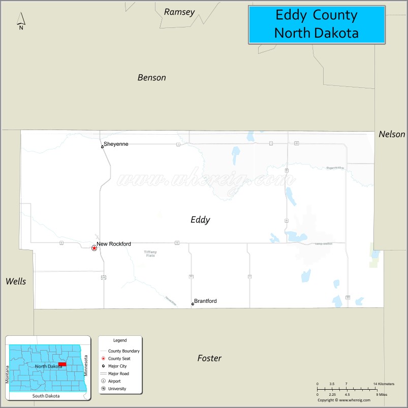
About Eddy County Map, North Dakota: The map showing the county boundary, county seat, major cities, highways, water bodies and neighbouring counties.
More North Dakota Maps & Info
About Eddy County, North Dakota
Eddy County is a county located in the U.S. state of North Dakota. It's county seat is New Rockford. As per 2020 census, the population of Eddy County is 2337 people and population density is square miles. According to the United States Census Bureau, the county has a total area of 632 sq mi (1,637 km2). Eddy County was established on 1885.
Eddy County Facts
| Continent | North America |
| Country | United States |
| State | North Dakota |
| County Seat | New Rockford |
| Largest City/Town | New Rockford |
| Established | 1885 |
| Total Area | 644.7 sq mi (1,669.8 sq km) |
| Land Area | 630.6 sq mi (1,633.3 sq km) |
| Water Area | 14.1 sq mi (36.5 sq km) |
| Population | 2,347 (Census 2020) |
| Population Density | 3.7 people per sq mi |
| Time Zone | Central Time Zone |
| Major Highways | US Highway 281, North Dakota Highway 15, North Dakota Highway 20 |
| Major Rivers | Sheyenne River, James River tributaries |
| Neighboring Counties | Pierce, Benson, Wells, Foster, Nelson, Ramsey |
| Famous For | Prairie pothole wetlands, agriculture, hunting, New Rockford, and railroad heritage |
| Top Attractions | Eddy County Museum, New Rockford Railroad Museum, Sheyenne River Valley, Lake Juanita, Devils Lake region wildlife areas |
| Official Website | Official Website |
About Eddy County, North Dakota
Eddy County is located in central North Dakota and was established in 1885. The county seat and largest city is New Rockford. The county lies within the prairie pothole region, an area known for its wetlands, waterfowl habitat, and productive farmland. Agriculture, hunting, and outdoor recreation play important roles in the local economy and culture.
Cities and Towns in Eddy County, North Dakota
| City/Town | Population (Census 2020) | Latitude & Longitude |
|---|---|---|
| New Rockford (county seat) | 1,239 | 47.6783°N, 99.1379°W |
| Sheyenne | 171 | 47.8253°N, 99.1179°W |
| Tolna | 136 | 47.8339°N, 98.4601°W |
| Grace City | 57 | 47.5515°N, 98.8270°W |
| Warwick | 55 | 47.8560°N, 98.7184°W |
| Brinsmade | 30 | 48.2486°N, 99.1776°W |
| Minnewaukan Beach (CDP) | 23 | 47.7820°N, 99.0200°W |
Best Golf Courses in Eddy County, North Dakota
| Golf Course | Location | Latitude & Longitude |
|---|---|---|
| New Rockford Golf Course | New Rockford | 47.6832°N, 99.1440°W |
| Sheyenne Country Club | Sheyenne | 47.8265°N, 99.1204°W |
What are Major Roads and Highways in Eddy County
Major highways connect the county to nearby regions and cities.
- US Highway 281 - north-south route connecting New Rockford with Devils Lake, Jamestown, and central North Dakota
- North Dakota Highway 15 - east-west route serving New Rockford and neighboring counties
- North Dakota Highway 20 - provides access to Benson, Ramsey, and Foster counties
- County roads connect farms, wetlands, wildlife areas, and rural communities throughout the county
Neighboring Counties of Eddy County
- Ramsey County (north)
- Benson County (northwest)
- Pierce County (west)
- Wells County (southwest)
- Foster County (south)
- Nelson County (east)
What are Top Attractions in Eddy County, North Dakota
The county offers a mix of natural and cultural attractions.
| Main Sight Name | City | Famous For |
|---|---|---|
| Eddy County Museum | New Rockford | Local history exhibits and pioneer artifacts |
| New Rockford Railroad Museum | New Rockford | Railroad history and regional transportation heritage |
| Sheyenne River Valley | Countywide | Scenic prairie landscapes and wildlife habitat |
| Lake Juanita | Near New Rockford | Fishing, boating, and outdoor recreation |
| Arrowwood National Wildlife Refuge Area | South of County | Birdwatching and migratory waterfowl habitat |
| Grace City Community Park | Grace City | Outdoor recreation and local events |
| Tolna Community Center Area | Tolna | Community gatherings and local history |
| Prairie Pothole Wetlands | Countywide | Important waterfowl habitat and photography opportunities |
| New Rockford Golf Course | New Rockford | Golf and outdoor recreation |
| Hunting Areas of Eddy County | Countywide | Pheasant, deer, and waterfowl hunting |
Distance from Eddy County to Nearby Cities
The following distances are measured by road (driving).
- New Rockford to Sheyenne (Eddy County), North Dakota - 11 mi (18 km)
- New Rockford to Tolna (Nelson County), North Dakota - 27 mi (43 km)
- New Rockford to Devils Lake (Ramsey County), North Dakota - 37 mi (60 km)
- New Rockford to Carrington (Foster County), North Dakota - 30 mi (48 km)
- New Rockford to Rugby (Pierce County), North Dakota - 42 mi (68 km)
- New Rockford to Harvey (Wells County), North Dakota - 41 mi (66 km)
- New Rockford to Minnewaukan (Benson County), North Dakota - 43 mi (69 km)
- New Rockford to Cooperstown (Griggs County), North Dakota - 55 mi (89 km)
- New Rockford to Jamestown (Stutsman County), North Dakota - 84 mi (135 km)
- New Rockford to Grand Forks (Grand Forks County), North Dakota - 103 mi (166 km)
- New Rockford to Fargo (Cass County), North Dakota - 134 mi (216 km)
- New Rockford to Bismarck (Burleigh County), North Dakota - 118 mi (190 km)
- New Rockford to Minot (Ward County), North Dakota - 102 mi (164 km)
- New Rockford to Wahpeton (Richland County), North Dakota - 180 mi (290 km)
- New Rockford to Williston (Williams County), North Dakota - 214 mi (344 km)
References
- QuickFacts - U.S. Census Bureau
- United States Census Bureau
- United States Geological Survey (USGS)
- National Geodetic Survey
- Official County Website
- Adams County Map
- Barnes County Map
- Benson County Map
- Billings County Map
- Bottineau County Map
- Bowman County Map
- Burke County Map
- Burleigh County Map
- Cass County Map
- Cavalier County Map
- Dickey County Map
- Divide County Map
- Dunn County Map
- Eddy County Map
- Emmons County Map
- Foster County Map
- Golden Valley County Map
- Grand Forks County Map
- Grant County Map
- Griggs County Map
- Hettinger County Map
- Kidder County Map
- LaMoure County Map
- Logan County Map
- McHenry County Map
- McKenzie County Map
- McLean County Map
- McIntosh County Map
- Mercer County Map
- Morton County Map
- Mountrail County Map
- Nelson County Map
- Oliver County Map
- Pembina County Map
- Pierce County Map
- Ramsey County Map
- Ransom County Map
- Renville County Map
- Richland County Map
- Rolette County Map
- Sargent County Map
- Sheridan County Map
- Sioux County Map
- Slope County Map
- Stark County Map
- Steele County Map
- Stutsman County Map
- Towner County Map
- Traill County Map
- Walsh County Map
- Ward County Map
- Wells County Map
- Williams County Map
- Alabama Counties
- Alaska boroughs
- Arizona Counties
- Arkansas Counties
- California County Map
- Colorado Counties
- Connecticut Counties
- Delaware Counties
- Florida County Map
- Georgia County Map
- Hawaii Counties
- Idaho Counties
- Illinois Counties
- Indiana Counties
- Iowa Counties
- Kansas Counties
- Kentucky Counties
- Louisiana Counties
- Maine Counties
- Maryland Counties
- Massachusetts Counties
- Michigan County Map
- Minnesota Counties
- Mississippi Counties
- Missouri Counties
- Montana Counties
- Nebraska Counties
- Nevada Counties
- New York Counties
- New Hampshire Counties
- New Jersey Counties
- New Mexico Counties
- North Carolina Counties
- North Dakota Counties
- Ohio County Map
- Oklahoma Counties
- Oregon Counties
- Pennsylvania Counties
- Rhode Island Counties
- South Carolina Counties
- South Dakota Counties
- Map of Tennessee
- Texas County Map
- Utah Counties
- Vermont Counties
- Virginia Counties
- Washington Counties
- West Virginia Counties
- Wisconsin Counties
- Wyoming Counties