Written and Fact-checked by Whereig Editors | Updated On: May 31, 2026
Map of Dickey County - Dickey County is a county located in the U.S. state of North Dakota. Dickey County Map showing cities, highways, important places and water bodies. Get Where is Dickey County located in the map, major cities in Dickey county, population, areas, and places of interest.
Map of Dickey County, North Dakota
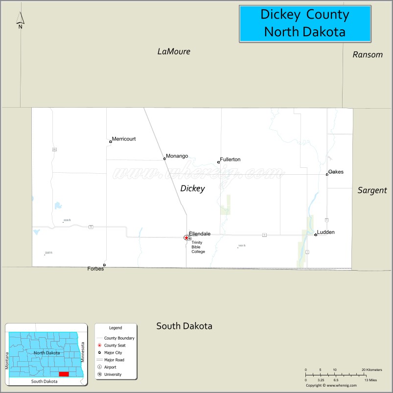
About Dickey County Map, North Dakota: The map showing the county boundary, county seat, major cities, highways, water bodies and neighbouring counties.
More North Dakota Maps & Info
About Dickey County, North Dakota
Dickey County is a county located in the U.S. state of North Dakota. It's county seat is Ellendale. As per 2020 census, the population of Dickey County is 4897 people and population density is square miles. According to the United States Census Bureau, the county has a total area of 1,131 sq mi (2,929 km2). Dickey County was established on 1881.
Dickey County Facts
| Continent | North America |
| Country | United States |
| State | North Dakota |
| County Seat | Ellendale |
| Largest City/Town | Oakes |
| Established | 1881 (organized 1882) |
| Total Area | 1,142.2 sq mi (2,958.3 sq km) |
| Land Area | 1,131.5 sq mi (2,930.6 sq km) |
| Water Area | 10.7 sq mi (27.7 sq km) |
| Population | 4,999 (Census 2020) |
| Population Density | 4.4 people per sq mi |
| Time Zone | Central Time Zone |
| Major Highways | US Highway 281, North Dakota Highway 11, North Dakota Highway 13 |
| Major Rivers | James River, Maple River |
| Neighboring Counties | LaMoure, Ransom, Sargent, McIntosh, Brown County (SD), Marshall County (SD) |
| Famous For | Rich farmland, Oakes Irrigation Project, agriculture, hunting, and the James River Valley |
| Top Attractions | Oakes Irrigation Project, Dickey County Heritage Center, James River, Elm Lake Wildlife Management Area, Ellendale Opera House |
| Official Website | Official Website |
About Dickey County, North Dakota
Dickey County is located in the southeastern part of North Dakota and was established in 1881. The county seat is Ellendale, while Oakes is the largest city. The county lies within the fertile James River Valley and is known for productive farmland, irrigation agriculture, hunting opportunities, and rural prairie landscapes. Agriculture remains the foundation of the local economy.
Cities and Towns in Dickey County, North Dakota
| City/Town | Population (Census 2020) | Latitude & Longitude |
|---|---|---|
| Ellendale (county seat) | 1,173 | 46.0019°N, 98.5279°W |
| Oakes | 1,856 | 46.1386°N, 98.0923°W |
| Forbes | 36 | 45.9442°N, 98.7632°W |
| Fullerton | 49 | 46.1678°N, 98.4237°W |
| Monango | 28 | 46.1719°N, 98.5940°W |
| Merricourt | 37 | 46.2695°N, 98.1234°W |
| Ludden | 25 | 45.9954°N, 98.1228°W |
| Guelph | 247 | 46.0875°N, 98.2170°W |
Best Golf Courses in Dickey County, North Dakota
| Golf Course | Location | Latitude & Longitude |
|---|---|---|
| Oakes Golf Club | Oakes | 46.1318°N, 98.1041°W |
| Ellendale Country Club | Ellendale | 45.9990°N, 98.5405°W |
What are Major Roads and Highways in Dickey County
Major highways connect the county to nearby regions and cities.
- US Highway 281 - north-south route connecting Ellendale, Oakes, Jamestown, and South Dakota
- North Dakota Highway 11 - east-west highway linking Oakes with Ellendale and neighboring counties
- North Dakota Highway 13 - route serving communities in southern Dickey County
- County roads provide access to farms, ranches, wildlife areas, and rural communities
Neighboring Counties of Dickey County
- LaMoure County (north)
- Ransom County (northeast)
- Sargent County (east)
- Marshall County, South Dakota (south)
- Brown County, South Dakota (southwest)
- McIntosh County (west)
What are Top Attractions in Dickey County, North Dakota
The county offers a mix of natural and cultural attractions.
| Main Sight Name | City | Famous For |
|---|---|---|
| Oakes Irrigation Project | Oakes | Major agricultural irrigation system in southeastern North Dakota |
| Dickey County Heritage Center | Ellendale | Local history exhibits and pioneer artifacts |
| James River | Countywide | Fishing, wildlife viewing, and scenic landscapes |
| Ellendale Opera House | Ellendale | Historic performing arts and community events venue |
| Oakes Golf Club | Oakes | Golf and outdoor recreation |
| Ellendale Country Club | Ellendale | Golf and community events |
| Elm Lake Wildlife Management Area | Near Oakes | Birdwatching, hunting, and wildlife habitat |
| Whitestone Hill Historic Area | Near County Border | Historic site related to frontier history |
| Guelph Community Park | Guelph | Local recreation and outdoor activities |
| Prairie Hunting Areas | Countywide | Pheasant, deer, and waterfowl hunting opportunities |
Distance from Dickey County to Nearby Cities
The following distances are measured by road (driving).
- Ellendale to Oakes (Dickey County), North Dakota - 21 mi (34 km)
- Ellendale to Ashley (McIntosh County), North Dakota - 29 mi (47 km)
- Ellendale to Ellendale State University Area - 2 mi (3 km)
- Ellendale to Lisbon (Ransom County), North Dakota - 50 mi (80 km)
- Ellendale to Wahpeton (Richland County), North Dakota - 76 mi (122 km)
- Ellendale to Jamestown (Stutsman County), North Dakota - 67 mi (108 km)
- Ellendale to Valley City (Barnes County), North Dakota - 89 mi (143 km)
- Ellendale to Aberdeen (Brown County), South Dakota - 72 mi (116 km)
- Ellendale to Britton (Marshall County), South Dakota - 49 mi (79 km)
- Ellendale to Fargo (Cass County), North Dakota - 124 mi (200 km)
- Ellendale to Bismarck (Burleigh County), North Dakota - 132 mi (212 km)
- Ellendale to Grand Forks (Grand Forks County), North Dakota - 211 mi (340 km)
- Ellendale to Minot (Ward County), North Dakota - 222 mi (357 km)
- Ellendale to Sioux Falls (Minnehaha County), South Dakota - 210 mi (338 km)
- Ellendale to Pierre (Hughes County), South Dakota - 190 mi (306 km)
References
- QuickFacts - Dickey County, North Dakota
- United States Census Bureau
- United States Geological Survey (USGS)
- National Geodetic Survey
- Official County Website
- Adams County Map
- Barnes County Map
- Benson County Map
- Billings County Map
- Bottineau County Map
- Bowman County Map
- Burke County Map
- Burleigh County Map
- Cass County Map
- Cavalier County Map
- Dickey County Map
- Divide County Map
- Dunn County Map
- Eddy County Map
- Emmons County Map
- Foster County Map
- Golden Valley County Map
- Grand Forks County Map
- Grant County Map
- Griggs County Map
- Hettinger County Map
- Kidder County Map
- LaMoure County Map
- Logan County Map
- McHenry County Map
- McKenzie County Map
- McLean County Map
- McIntosh County Map
- Mercer County Map
- Morton County Map
- Mountrail County Map
- Nelson County Map
- Oliver County Map
- Pembina County Map
- Pierce County Map
- Ramsey County Map
- Ransom County Map
- Renville County Map
- Richland County Map
- Rolette County Map
- Sargent County Map
- Sheridan County Map
- Sioux County Map
- Slope County Map
- Stark County Map
- Steele County Map
- Stutsman County Map
- Towner County Map
- Traill County Map
- Walsh County Map
- Ward County Map
- Wells County Map
- Williams County Map
- Alabama Counties
- Alaska boroughs
- Arizona Counties
- Arkansas Counties
- California County Map
- Colorado Counties
- Connecticut Counties
- Delaware Counties
- Florida County Map
- Georgia County Map
- Hawaii Counties
- Idaho Counties
- Illinois Counties
- Indiana Counties
- Iowa Counties
- Kansas Counties
- Kentucky Counties
- Louisiana Counties
- Maine Counties
- Maryland Counties
- Massachusetts Counties
- Michigan County Map
- Minnesota Counties
- Mississippi Counties
- Missouri Counties
- Montana Counties
- Nebraska Counties
- Nevada Counties
- New York Counties
- New Hampshire Counties
- New Jersey Counties
- New Mexico Counties
- North Carolina Counties
- North Dakota Counties
- Ohio County Map
- Oklahoma Counties
- Oregon Counties
- Pennsylvania Counties
- Rhode Island Counties
- South Carolina Counties
- South Dakota Counties
- Map of Tennessee
- Texas County Map
- Utah Counties
- Vermont Counties
- Virginia Counties
- Washington Counties
- West Virginia Counties
- Wisconsin Counties
- Wyoming Counties