Written and Fact-checked by Whereig Editors | Updated On: May 31, 2026
Map of Golden Valley County - Golden Valley County is a county located in the U.S. state of North Dakota. Golden Valley County Map showing cities, highways, important places and water bodies. Get Where is Golden Valley County located in the map, major cities in Golden Valley county, population, areas, and places of interest.
Map of Golden Valley County, North Dakota
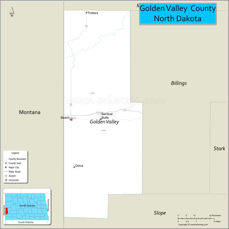
About Golden Valley County Map, North Dakota: The map showing the county boundary, county seat, major cities, highways, water bodies and neighbouring counties.
More North Dakota Maps & Info
About Golden Valley County, North Dakota
Golden Valley County is a county located in the U.S. state of North Dakota. It's county seat is Beach. As per 2020 census, the population of Golden Valley County is 1770 people and population density is square miles. According to the United States Census Bureau, the county has a total area of 1,002 sq mi (2,595 km2). Golden Valley County was established on 1912.p>
Golden Valley County Facts
| Continent | North America |
| Country | United States |
| State | North Dakota |
| County Seat | Beach |
| Largest City/Town | Beach |
| Established | 1912 |
| Total Area | 1,002.0 sq mi (2,595.2 sq km) |
| Land Area | 1,000.9 sq mi (2,592.3 sq km) |
| Water Area | 1.1 sq mi (2.8 sq km) |
| Population | 1,736 (Census 2020) |
| Population Density | 1.7 people per sq mi |
| Time Zone | Mountain Time Zone |
| Major Highways | Interstate 94, US Highway 85, North Dakota Highway 16 |
| Major Rivers | Little Missouri River |
| Neighboring Counties | Billings, Slope, Stark, McKenzie, Wibaux County (Montana) |
| Famous For | North Dakota Badlands, Little Missouri River Valley, ranching, energy production, and Theodore Roosevelt landscapes |
| Top Attractions | Theodore Roosevelt National Park (nearby South Unit access), Little Missouri State Scenic River, Beach Area Museum, Sentinel Butte, Buffalo Gap Campground |
| Official Website | Official Website |
About Golden Valley County, North Dakota
Golden Valley County is located in western North Dakota near the Montana border and was established in 1912. The county seat and largest city is Beach. The county features rolling prairie, rugged badlands, and the scenic Little Missouri River Valley. Ranching, agriculture, tourism, and energy development are important parts of the local economy. Population data is based on the 2020 Census. :contentReference[oaicite:0]{index=0}
Cities and Towns in Golden Valley County, North Dakota
| City/Town | Population (Census 2020) | Latitude & Longitude |
|---|---|---|
| Beach (county seat) | 1,019 | 46.9186°N, 103.9888°W |
| Golva | 61 | 46.7338°N, 103.9830°W |
| Sentinel Butte | 70 | 46.9122°N, 103.8380°W |
Best Golf Courses in Golden Valley County, North Dakota
| Golf Course | Location | Latitude & Longitude |
|---|---|---|
| Beach Golf Course | Beach | 46.9210°N, 103.9927°W |
| Bully Pulpit Golf Course | Medora (near county boundary) | 46.9134°N, 103.5313°W |
What are Major Roads and Highways in Golden Valley County
Major highways connect the county to nearby regions and cities.
- Interstate 94 - east-west interstate connecting Beach with Dickinson, Bismarck, Glendive, and Billings
- US Highway 85 - north-south route linking western North Dakota energy-producing regions
- North Dakota Highway 16 - connects Beach with Golva and southern communities
- County roads provide access to ranches, badlands, recreation areas, and rural settlements
Neighboring Counties of Golden Valley County
- McKenzie County (north)
- Billings County (east)
- Stark County (southeast)
- Slope County (south)
- Wibaux County, Montana (west)
What are Top Attractions in Golden Valley County, North Dakota
The county offers a mix of natural and cultural attractions.
| Main Sight Name | City | Famous For |
|---|---|---|
| Little Missouri River Valley | Countywide | Scenic badlands landscapes and wildlife viewing |
| Beach Area Museum | Beach | Regional history and pioneer exhibits |
| Sentinel Butte | Sentinel Butte | Historic landmark and panoramic prairie views |
| Buffalo Gap Campground | Beach | Camping and outdoor recreation |
| Theodore Roosevelt National Park South Unit | Near Medora | Badlands scenery, wildlife, and hiking |
| Little Missouri State Scenic River | Countywide | Canoeing, fishing, and nature viewing |
| Beach City Park | Beach | Community recreation and events |
| Golva Historic Area | Golva | Local history and prairie heritage |
| Western North Dakota Badlands | Countywide | Photography and scenic drives |
| Beach Golf Course | Beach | Golf and outdoor recreation |
Distance from Golden Valley County to Nearby Cities
The following distances are measured by road (driving).
- Beach to Sentinel Butte (Golden Valley County), North Dakota - 8 mi (13 km)
- Beach to Golva (Golden Valley County), North Dakota - 16 mi (26 km)
- Beach to Medora (Billings County), North Dakota - 31 mi (50 km)
- Beach to Dickinson (Stark County), North Dakota - 57 mi (92 km)
- Beach to Belfield (Stark County), North Dakota - 41 mi (66 km)
- Beach to Watford City (McKenzie County), North Dakota - 96 mi (154 km)
- Beach to Bowman (Bowman County), North Dakota - 71 mi (114 km)
- Beach to Glendive (Dawson County), Montana - 36 mi (58 km)
- Beach to Miles City (Custer County), Montana - 113 mi (182 km)
- Beach to Williston (Williams County), North Dakota - 132 mi (212 km)
- Beach to Bismarck (Burleigh County), North Dakota - 194 mi (312 km)
- Beach to Minot (Ward County), North Dakota - 209 mi (336 km)
- Beach to Fargo (Cass County), North Dakota - 337 mi (542 km)
- Beach to Grand Forks (Grand Forks County), North Dakota - 355 mi (571 km)
- Beach to Billings (Yellowstone County), Montana - 191 mi (307 km)
References
- QuickFacts - Golden Valley County, North Dakota
- United States Census Bureau
- United States Geological Survey (USGS)
- National Geodetic Survey
- Official County Website
- Adams County Map
- Barnes County Map
- Benson County Map
- Billings County Map
- Bottineau County Map
- Bowman County Map
- Burke County Map
- Burleigh County Map
- Cass County Map
- Cavalier County Map
- Dickey County Map
- Divide County Map
- Dunn County Map
- Eddy County Map
- Emmons County Map
- Foster County Map
- Golden Valley County Map
- Grand Forks County Map
- Grant County Map
- Griggs County Map
- Hettinger County Map
- Kidder County Map
- LaMoure County Map
- Logan County Map
- McHenry County Map
- McKenzie County Map
- McLean County Map
- McIntosh County Map
- Mercer County Map
- Morton County Map
- Mountrail County Map
- Nelson County Map
- Oliver County Map
- Pembina County Map
- Pierce County Map
- Ramsey County Map
- Ransom County Map
- Renville County Map
- Richland County Map
- Rolette County Map
- Sargent County Map
- Sheridan County Map
- Sioux County Map
- Slope County Map
- Stark County Map
- Steele County Map
- Stutsman County Map
- Towner County Map
- Traill County Map
- Walsh County Map
- Ward County Map
- Wells County Map
- Williams County Map
- Alabama Counties
- Alaska boroughs
- Arizona Counties
- Arkansas Counties
- California County Map
- Colorado Counties
- Connecticut Counties
- Delaware Counties
- Florida County Map
- Georgia County Map
- Hawaii Counties
- Idaho Counties
- Illinois Counties
- Indiana Counties
- Iowa Counties
- Kansas Counties
- Kentucky Counties
- Louisiana Counties
- Maine Counties
- Maryland Counties
- Massachusetts Counties
- Michigan County Map
- Minnesota Counties
- Mississippi Counties
- Missouri Counties
- Montana Counties
- Nebraska Counties
- Nevada Counties
- New York Counties
- New Hampshire Counties
- New Jersey Counties
- New Mexico Counties
- North Carolina Counties
- North Dakota Counties
- Ohio County Map
- Oklahoma Counties
- Oregon Counties
- Pennsylvania Counties
- Rhode Island Counties
- South Carolina Counties
- South Dakota Counties
- Map of Tennessee
- Texas County Map
- Utah Counties
- Vermont Counties
- Virginia Counties
- Washington Counties
- West Virginia Counties
- Wisconsin Counties
- Wyoming Counties