Written and Fact-checked by Whereig Editors | Updated On: May 31, 2026
Map of Stutsman County - Stutsman County is a county located in the U.S. state of North Dakota. Stutsman County Map showing cities, highways, important places and water bodies. Get Where is Stutsman County located in the map, major cities in Stutsman county, population, areas, and places of interest.
Map of Stutsman County, North Dakota
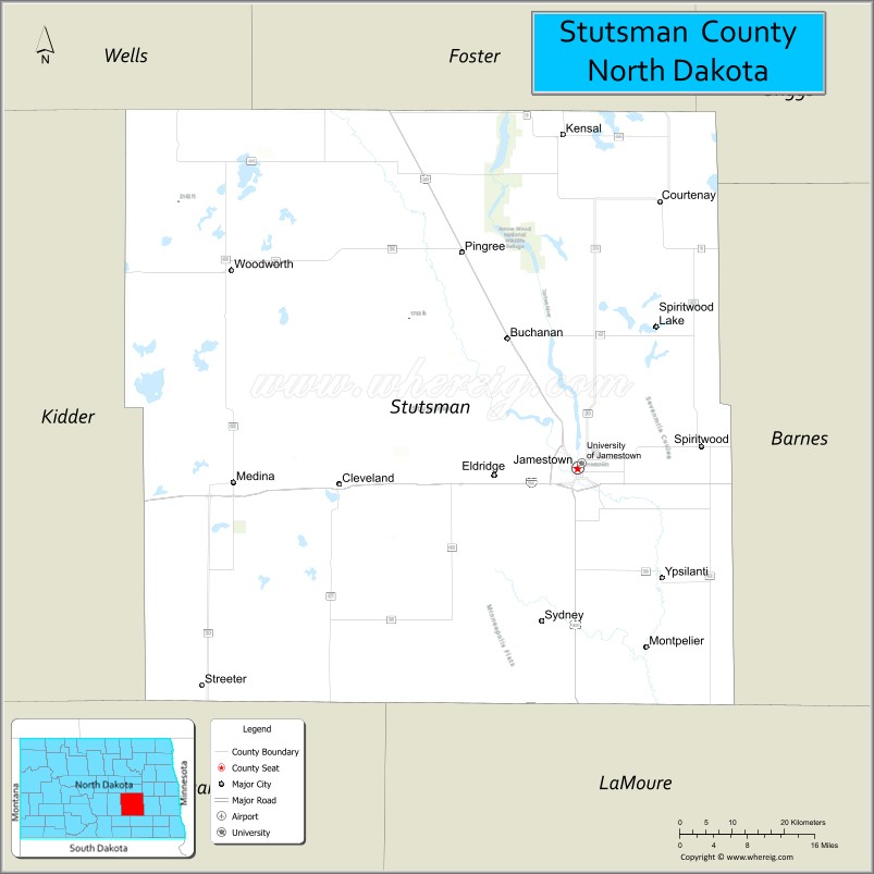
About Stutsman County Map, North Dakota: The map showing the county boundary, county seat, major cities, highways, water bodies and neighbouring counties.
More North Dakota Maps & Info
About Stutsman County, North Dakota
Stutsman County is a county located in the U.S. state of North Dakota. It's county seat is Jamestown. As per 2020 census, the population of Stutsman County is 21576 people and population density is square miles. According to the United States Census Bureau, the county has a total area of 2,222 sq mi (5,755 km2). Stutsman County was established on 1873.
Stutsman County Facts
| Continent | North America |
| Country | United States |
| State | North Dakota |
| County Seat | Jamestown |
| Largest City/Town | Jamestown |
| Established | 1873 |
| Total Area | 2,298.0 sq mi (5,951.8 sq km) |
| Land Area | 2,222.0 sq mi (5,755.0 sq km) |
| Water Area | 76.0 sq mi (196.8 sq km) |
| Population | 21,593 (Census 2020) |
| Population Density | 9.7 people per sq mi |
| Time Zone | Central Time Zone |
| Major Highways | Interstate 94, US Highway 52, US Highway 281, North Dakota Highway 20, North Dakota Highway 30, North Dakota Highway 36 |
| Major Rivers | James River, Pipestem Creek |
| Neighboring Counties | Foster County, Wells County, Kidder County, Barnes County, LaMoure County, Logan County |
| Famous For | Jamestown, World's Largest Buffalo Monument, Frontier Village, Jamestown Reservoir, and the James River Valley |
| Top Attractions | World's Largest Buffalo Monument, Frontier Village, Jamestown Reservoir, National Buffalo Museum, Pipestem Creek Trail |
| Official Website | Official Website |
About Stutsman County, North Dakota
Stutsman County is located in south-central North Dakota and was established in 1873. The county seat and largest city is Jamestown. As the largest county in North Dakota by area, it features extensive prairie landscapes, agricultural land, wetlands, and recreation areas. The county serves as a regional center for commerce, education, healthcare, and tourism along Interstate 94.
Cities and Towns in Stutsman County, North Dakota
| City/Town | Population (Census 2020) | Latitude & Longitude |
|---|---|---|
| Jamestown (county seat) | 15,849 | 46.9105°N, 98.7084°W |
| Buchanan | 90 | 46.8892°N, 98.8276°W |
| Cleveland | 82 | 46.9772°N, 99.1121°W |
| Courtenay | 57 | 47.2163°N, 98.5637°W |
| Kensal | 141 | 47.2862°N, 99.0240°W |
| Medina | 263 | 46.8949°N, 99.2993°W |
| Montpelier | 87 | 46.7008°N, 98.5854°W |
| Pingree | 44 | 47.1658°N, 98.9068°W |
| Spiritwood | 105 | 47.0907°N, 98.5856°W |
| Streeter | 149 | 46.6575°N, 99.3518°W |
| Ypsilanti | 47 | 46.7791°N, 98.5059°W |
| Eldridge (CDP) | 73 | 46.9529°N, 98.7981°W |
| Windsor (CDP) | 79 | 46.9256°N, 98.3657°W |
Best Golf Courses in Stutsman County, North Dakota
| Golf Course | Location | Latitude & Longitude |
|---|---|---|
| Jamestown Country Club | Jamestown | 46.9427°N, 98.7204°W |
| Hillcrest Municipal Golf Course | Jamestown | 46.9118°N, 98.7247°W |
| Pipestem Creek Golf Course | Jamestown | 46.9546°N, 98.7349°W |
| Medina Municipal Golf Course | Medina | 46.8972°N, 99.3106°W |
What are Major Roads and Highways in Stutsman County
Major highways connect the county to nearby regions and cities.
- Interstate 94 - major east-west interstate connecting Jamestown with Fargo, Bismarck, and western North Dakota
- US Highway 52 - northwest-southeast route serving Jamestown and connecting several regional communities
- US Highway 281 - north-south route linking Jamestown with Carrington, Ellendale, and central North Dakota
- North Dakota Highway 20 - connects Spiritwood and eastern portions of the county
- North Dakota Highway 30 - serves agricultural communities north of Jamestown
- North Dakota Highway 36 - provides access to southern portions of the county
Neighboring Counties of Stutsman County
- Foster County (north)
- Wells County (northwest)
- Kidder County (west)
- Logan County (southwest)
- LaMoure County (south)
- Barnes County (east)
What are Top Attractions in Stutsman County, North Dakota
The county offers a mix of natural and cultural attractions.
| Main Sight Name | City | Famous For |
|---|---|---|
| World's Largest Buffalo Monument | Jamestown | Iconic roadside landmark and symbol of the city |
| National Buffalo Museum | Jamestown | Bison exhibits, history, and live buffalo herd |
| Frontier Village | Jamestown | Historic pioneer buildings and western heritage |
| Jamestown Reservoir | Jamestown | Boating, fishing, camping, and recreation |
| Pipestem Creek Trail | Jamestown | Walking, biking, and nature observation |
| Fort Seward Historic Site | Jamestown | Historic military post and scenic overlook |
| Stutsman County Memorial Museum | Jamestown | County history and cultural exhibits |
| Jamestown Arts Center | Jamestown | Visual arts and community programs |
| Pipestem Dam | Jamestown | Water recreation and wildlife viewing |
| Spiritwood Lake Area | Spiritwood | Fishing and outdoor recreation |
| Hillcrest Golf Course | Jamestown | Public golf and city recreation |
| James River Valley | Countywide | Scenic landscapes and wildlife habitat |
Distance from Stutsman County to Nearby Cities
The following distances are measured by road (driving).
- Jamestown to Medina (Stutsman County), North Dakota - 23 mi (37 km)
- Jamestown to Kensal (Stutsman County), North Dakota - 25 mi (40 km)
- Jamestown to Spiritwood (Stutsman County), North Dakota - 14 mi (23 km)
- Jamestown to Carrington (Foster County), North Dakota - 43 mi (69 km)
- Jamestown to Valley City (Barnes County), North Dakota - 37 mi (60 km)
- Jamestown to Steele (Kidder County), North Dakota - 41 mi (66 km)
- Jamestown to LaMoure (LaMoure County), North Dakota - 52 mi (84 km)
- Jamestown to Ellendale (Dickey County), North Dakota - 86 mi (138 km)
- Jamestown to Devils Lake (Ramsey County), North Dakota - 99 mi (159 km)
- Jamestown to Fargo (Cass County), North Dakota - 95 mi (153 km)
- Jamestown to Bismarck (Burleigh County), North Dakota - 100 mi (161 km)
- Jamestown to Minot (Ward County), North Dakota - 128 mi (206 km)
- Jamestown to Grand Forks (Grand Forks County), North Dakota - 145 mi (233 km)
- Jamestown to Dickinson (Stark County), North Dakota - 199 mi (320 km)
- Jamestown to Wahpeton (Richland County), North Dakota - 128 mi (206 km)
References
- QuickFacts - Stutsman County, North Dakota
- United States Census Bureau
- United States Geological Survey (USGS)
- National Geodetic Survey
- Official County Website
- Adams County Map
- Barnes County Map
- Benson County Map
- Billings County Map
- Bottineau County Map
- Bowman County Map
- Burke County Map
- Burleigh County Map
- Cass County Map
- Cavalier County Map
- Dickey County Map
- Divide County Map
- Dunn County Map
- Eddy County Map
- Emmons County Map
- Foster County Map
- Golden Valley County Map
- Grand Forks County Map
- Grant County Map
- Griggs County Map
- Hettinger County Map
- Kidder County Map
- LaMoure County Map
- Logan County Map
- McHenry County Map
- McKenzie County Map
- McLean County Map
- McIntosh County Map
- Mercer County Map
- Morton County Map
- Mountrail County Map
- Nelson County Map
- Oliver County Map
- Pembina County Map
- Pierce County Map
- Ramsey County Map
- Ransom County Map
- Renville County Map
- Richland County Map
- Rolette County Map
- Sargent County Map
- Sheridan County Map
- Sioux County Map
- Slope County Map
- Stark County Map
- Steele County Map
- Stutsman County Map
- Towner County Map
- Traill County Map
- Walsh County Map
- Ward County Map
- Wells County Map
- Williams County Map
- Alabama Counties
- Alaska boroughs
- Arizona Counties
- Arkansas Counties
- California County Map
- Colorado Counties
- Connecticut Counties
- Delaware Counties
- Florida County Map
- Georgia County Map
- Hawaii Counties
- Idaho Counties
- Illinois Counties
- Indiana Counties
- Iowa Counties
- Kansas Counties
- Kentucky Counties
- Louisiana Counties
- Maine Counties
- Maryland Counties
- Massachusetts Counties
- Michigan County Map
- Minnesota Counties
- Mississippi Counties
- Missouri Counties
- Montana Counties
- Nebraska Counties
- Nevada Counties
- New York Counties
- New Hampshire Counties
- New Jersey Counties
- New Mexico Counties
- North Carolina Counties
- North Dakota Counties
- Ohio County Map
- Oklahoma Counties
- Oregon Counties
- Pennsylvania Counties
- Rhode Island Counties
- South Carolina Counties
- South Dakota Counties
- Map of Tennessee
- Texas County Map
- Utah Counties
- Vermont Counties
- Virginia Counties
- Washington Counties
- West Virginia Counties
- Wisconsin Counties
- Wyoming Counties