Written and Fact-checked by Whereig Editors | Updated On: May 31, 2026
Map of Dunn County - Dunn County is a county located in the U.S. state of North Dakota. Dunn County Map showing cities, highways, important places and water bodies. Get Where is Dunn County located in the map, major cities in Dunn county, population, areas, and places of interest.
Map of Dunn County, North Dakota
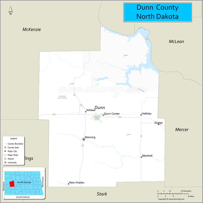
About Dunn County Map, North Dakota: The map showing the county boundary, county seat, major cities, highways, water bodies and neighbouring counties.
More North Dakota Maps & Info
About Dunn County, North Dakota
Dunn County is a county located in the U.S. state of North Dakota. It's county seat is Manning. As per 2020 census, the population of Dunn County is 4035 people and population density is square miles. According to the United States Census Bureau, the county has a total area of 2,010 sq mi (5,206 km2). Dunn County was established on 1883.
Dunn County Facts
| Continent | North America |
| Country | United States |
| State | North Dakota |
| County Seat | Manning |
| Largest City/Town | Killdeer |
| Established | 1908 |
| Total Area | 2,082.3 sq mi (5,393.1 sq km) |
| Land Area | 2,008.2 sq mi (5,201.2 sq km) |
| Water Area | 74.1 sq mi (191.9 sq km) |
| Population | 4,095 (Census 2020) |
| Population Density | 2.0 people per sq mi |
| Time Zone | Mountain Time Zone |
| Major Highways | US Highway 85, North Dakota Highway 22, North Dakota Highway 200 |
| Major Rivers | Little Missouri River, Missouri River |
| Neighboring Counties | McKenzie, Mountrail, Mercer, Stark, Billings, Golden Valley |
| Famous For | Killdeer Mountains, Little Missouri State Park, oil production, ranching, and Theodore Roosevelt-era landscapes |
| Top Attractions | Little Missouri State Park, Killdeer Mountain Battlefield, Killdeer Mountains, Lake Sakakawea, Dunn County Museum |
| Official Website | Official Website |
About Dunn County, North Dakota
Dunn County is located in western North Dakota and was established in 1908. The county seat is Manning, while Killdeer is the largest city. The county contains portions of the Missouri River and Little Missouri River basins and is known for its rugged badlands, rolling prairie, ranching heritage, and energy production from the Bakken Formation. Outdoor recreation and scenic landscapes attract visitors throughout the year.
Cities and Towns in Dunn County, North Dakota
| City/Town | Population (Census 2020) | Latitude & Longitude |
|---|---|---|
| Manning (county seat) | 47 | 47.2319°N, 102.8319°W |
| Killdeer | 1,024 | 47.3719°N, 102.7541°W |
| Dodge | 123 | 47.2947°N, 102.2204°W |
| Halliday | 184 | 47.3538°N, 102.3386°W |
| New Hradec | 27 | 46.9947°N, 102.8835°W |
| Marshall (CDP) | 66 | 47.1318°N, 102.7674°W |
| Twin Buttes (CDP) | 731 | 47.5524°N, 102.6343°W |
Best Golf Courses in Dunn County, North Dakota
| Golf Course | Location | Latitude & Longitude |
|---|---|---|
| Killdeer Mountain Golf Club | Killdeer | 47.3760°N, 102.7605°W |
| Pheasant Country Golf Course | Halliday | 47.3546°N, 102.3404°W |
What are Major Roads and Highways in Dunn County
Major highways connect the county to nearby regions and cities.
- US Highway 85 - major north-south corridor connecting Killdeer with Watford City, Belfield, and South Dakota
- North Dakota Highway 22 - links Killdeer with Dickinson, New Town, and central North Dakota
- North Dakota Highway 200 - east-west route crossing the northern portion of the county
- County roads provide access to oil fields, ranches, recreational areas, and rural communities
Neighboring Counties of Dunn County
- McKenzie County (northwest)
- Mountrail County (north)
- Mercer County (east)
- Stark County (south)
- Billings County (southwest)
- Golden Valley County (west)
What are Top Attractions in Dunn County, North Dakota
The county offers a mix of natural and cultural attractions.
| Main Sight Name | City | Famous For |
|---|---|---|
| Little Missouri State Park | Near Killdeer | Horseback riding, camping, hiking, and badlands scenery |
| Killdeer Mountain Battlefield State Historic Site | Killdeer Area | Historic 1864 battle site and interpretive exhibits |
| Killdeer Mountains | Killdeer | Scenic hills, wildlife, and panoramic views |
| Lake Sakakawea Recreation Areas | Twin Buttes Area | Boating, fishing, and camping |
| Dunn County Museum | Dunn Center Area | Local history and pioneer artifacts |
| Little Missouri River Valley | Countywide | Badlands scenery and wildlife viewing |
| Twin Buttes Marina Area | Twin Buttes | Water recreation and fishing access |
| Killdeer Mountain Golf Club | Killdeer | Golf with scenic prairie views |
| Halliday Community Park | Halliday | Local recreation and events |
| Dunn County Fairgrounds | Killdeer | Agricultural exhibitions and community events |
Distance from Dunn County to Nearby Cities
The following distances are measured by road (driving).
- Manning to Killdeer (Dunn County), North Dakota - 7 mi (11 km)
- Manning to Halliday (Dunn County), North Dakota - 31 mi (50 km)
- Manning to Dodge (Dunn County), North Dakota - 38 mi (61 km)
- Manning to Dickinson (Stark County), North Dakota - 44 mi (71 km)
- Manning to Watford City (McKenzie County), North Dakota - 52 mi (84 km)
- Manning to New Town (Mountrail County), North Dakota - 57 mi (92 km)
- Manning to Beulah (Mercer County), North Dakota - 66 mi (106 km)
- Manning to Medora (Billings County), North Dakota - 75 mi (121 km)
- Manning to Williston (Williams County), North Dakota - 91 mi (146 km)
- Manning to Bismarck (Burleigh County), North Dakota - 108 mi (174 km)
- Manning to Minot (Ward County), North Dakota - 128 mi (206 km)
- Manning to Bowman (Bowman County), North Dakota - 118 mi (190 km)
- Manning to Fargo (Cass County), North Dakota - 304 mi (489 km)
- Manning to Grand Forks (Grand Forks County), North Dakota - 276 mi (444 km)
- Manning to Rapid City (Pennington County), South Dakota - 265 mi (427 km)
References
- QuickFacts - U.S. Census Bureau
- United States Census Bureau
- United States Geological Survey (USGS)
- National Geodetic Survey
- Official County Website
- Adams County Map
- Barnes County Map
- Benson County Map
- Billings County Map
- Bottineau County Map
- Bowman County Map
- Burke County Map
- Burleigh County Map
- Cass County Map
- Cavalier County Map
- Dickey County Map
- Divide County Map
- Dunn County Map
- Eddy County Map
- Emmons County Map
- Foster County Map
- Golden Valley County Map
- Grand Forks County Map
- Grant County Map
- Griggs County Map
- Hettinger County Map
- Kidder County Map
- LaMoure County Map
- Logan County Map
- McHenry County Map
- McKenzie County Map
- McLean County Map
- McIntosh County Map
- Mercer County Map
- Morton County Map
- Mountrail County Map
- Nelson County Map
- Oliver County Map
- Pembina County Map
- Pierce County Map
- Ramsey County Map
- Ransom County Map
- Renville County Map
- Richland County Map
- Rolette County Map
- Sargent County Map
- Sheridan County Map
- Sioux County Map
- Slope County Map
- Stark County Map
- Steele County Map
- Stutsman County Map
- Towner County Map
- Traill County Map
- Walsh County Map
- Ward County Map
- Wells County Map
- Williams County Map
- Alabama Counties
- Alaska boroughs
- Arizona Counties
- Arkansas Counties
- California County Map
- Colorado Counties
- Connecticut Counties
- Delaware Counties
- Florida County Map
- Georgia County Map
- Hawaii Counties
- Idaho Counties
- Illinois Counties
- Indiana Counties
- Iowa Counties
- Kansas Counties
- Kentucky Counties
- Louisiana Counties
- Maine Counties
- Maryland Counties
- Massachusetts Counties
- Michigan County Map
- Minnesota Counties
- Mississippi Counties
- Missouri Counties
- Montana Counties
- Nebraska Counties
- Nevada Counties
- New York Counties
- New Hampshire Counties
- New Jersey Counties
- New Mexico Counties
- North Carolina Counties
- North Dakota Counties
- Ohio County Map
- Oklahoma Counties
- Oregon Counties
- Pennsylvania Counties
- Rhode Island Counties
- South Carolina Counties
- South Dakota Counties
- Map of Tennessee
- Texas County Map
- Utah Counties
- Vermont Counties
- Virginia Counties
- Washington Counties
- West Virginia Counties
- Wisconsin Counties
- Wyoming Counties