Written and Fact-checked by Whereig Editors | Updated On: May 31, 2026
Map of Ward County - Ward County is a county located in the U.S. state of North Dakota. Ward County Map showing cities, highways, important places and water bodies. Get Where is Ward County located in the map, major cities in Ward county, population, areas, and places of interest.
Map of Ward County, North Dakota
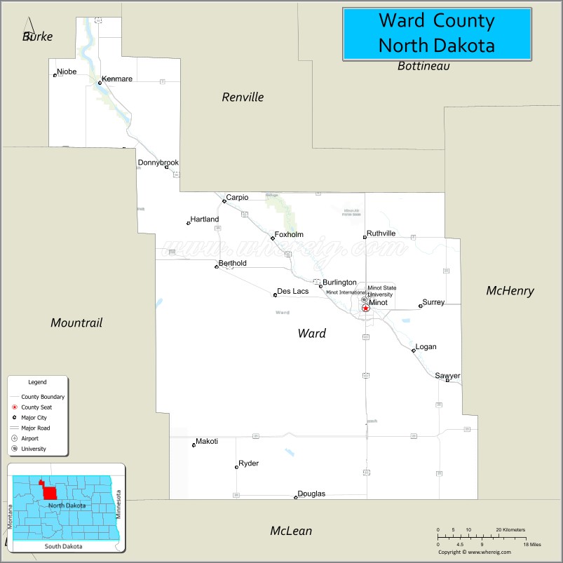
About Ward County Map, North Dakota: The map showing the county boundary, county seat, major cities, highways, water bodies and neighbouring counties.
More North Dakota Maps & Info
About Ward County, North Dakota
Ward County is a county located in the U.S. state of North Dakota. It's county seat is Minot. As per 2020 census, the population of Ward County is 69071 people and population density is square miles. According to the United States Census Bureau, the county has a total area of 2,013 sq mi (5,214 km2). Ward County was established on 1888.
Ward County Facts
| Continent | North America |
| Country | United States |
| State | North Dakota |
| County Seat | Minot |
| Largest City/Town | Minot |
| Established | 1885 |
| Total Area | 2,013.0 sq mi (5,213.6 sq km) |
| Land Area | 2,013.0 sq mi (5,213.6 sq km) |
| Water Area | 0.3 sq mi (0.8 sq km) |
| Population | 69,919 (Census 2020) |
| Population Density | 34.7 people per sq mi |
| Time Zone | Central Time Zone |
| Major Highways | US Highway 2, US Highway 52, US Highway 83, US Highway 281, North Dakota Highway 23 |
| Major Rivers | Souris River (Mouse River), Des Lacs River |
| Neighboring Counties | Renville County, Bottineau County, McHenry County, Pierce County, Mountrail County, McLean County |
| Famous For | Minot, Minot Air Force Base, North Dakota State Fair, Scandinavian Heritage Park, and regional commerce |
| Top Attractions | Scandinavian Heritage Park, Roosevelt Park Zoo, North Dakota State Fairgrounds, Dakota Territory Air Museum, and Souris River Valley |
| Official Website | Official Website |
About Ward County, North Dakota
Ward County is located in north-central North Dakota and was established in 1885. The county seat and largest city is Minot. As the fourth-most populous county in North Dakota, it serves as a major economic, educational, healthcare, and transportation hub for the northwestern part of the state. The Souris River flows through the county and contributes to its scenic landscape and recreational opportunities.
Cities and Towns in Ward County, North Dakota
| City/Town | Population (Census 2020) | Latitude & Longitude |
|---|---|---|
| Minot (county seat) | 48,377 | 48.2325°N, 101.2963°W |
| Berthold | 490 | 48.3131°N, 101.7368°W |
| Burlington | 1,060 | 48.2706°N, 101.4271°W |
| Carpio | 148 | 48.4478°N, 101.7057°W |
| Des Lacs | 204 | 48.2589°N, 101.5640°W |
| Douglas | 64 | 48.3108°N, 101.5099°W |
| Drake | 291 | 47.9441°N, 100.3701°W |
| Makoti | 154 | 47.9725°N, 101.8005°W |
| Ruthville | 50 | 48.4278°N, 101.3147°W |
| Ryder | 79 | 47.9231°N, 101.6771°W |
| Sawyer | 357 | 48.0917°N, 101.0537°W |
| Surrey | 1,143 | 48.2350°N, 101.1335°W |
| Logan (CDP) | 35 | 48.3112°N, 101.2385°W |
Best Golf Courses in Ward County, North Dakota
| Golf Course | Location | Latitude & Longitude |
|---|---|---|
| Vardon Golf Club | Minot | 48.1938°N, 101.2846°W |
| Jack Hoeven Wee Links | Minot | 48.1964°N, 101.2868°W |
| Souris Valley Golf Course | Minot | 48.2697°N, 101.2894°W |
| Minot Country Club | Minot | 48.2481°N, 101.3212°W |
| Des Lacs Golf Course | Des Lacs | 48.2617°N, 101.5764°W |
What are Major Roads and Highways in Ward County
Major highways connect the county to nearby regions and cities.
- US Highway 2 - major east-west route connecting Minot with Williston, Grand Forks, and surrounding communities
- US Highway 52 - northwest-southeast corridor linking Minot with Rugby and the Canadian border region
- US Highway 83 - north-south highway connecting Minot with Bismarck and Canada
- US Highway 281 - serves eastern portions of the county and links communities throughout central North Dakota
- North Dakota Highway 23 - provides access to western oil-producing regions and nearby counties
Neighboring Counties of Ward County
- Renville County (north)
- Bottineau County (northeast)
- McHenry County (east)
- Pierce County (southeast)
- McLean County (south)
- Mountrail County (west)
What are Top Attractions in Ward County, North Dakota
The county offers a mix of natural and cultural attractions.
| Main Sight Name | City | Famous For |
|---|---|---|
| Scandinavian Heritage Park | Minot | Nordic cultural exhibits and replica Scandinavian landmarks |
| Roosevelt Park Zoo | Minot | The oldest zoo in North Dakota |
| North Dakota State Fairgrounds | Minot | Home of the annual North Dakota State Fair |
| Dakota Territory Air Museum | Minot | Historic aircraft and aviation exhibits |
| Souris Valley Golf Course | Minot | Championship public golf facility |
| Oak Park | Minot | Community recreation and events |
| Taube Museum of Art | Minot | Regional art exhibitions and programs |
| Souris River Valley | Countywide | Scenic landscapes and wildlife habitat |
| Des Lacs National Wildlife Refuge | Des Lacs | Birdwatching and outdoor recreation |
| Minot Air Force Base Museum Area | North of Minot | Military heritage and history |
| Pioneer Village Museum | Burlington | Local history and pioneer artifacts |
| Norwegian Heritage Sites | Minot | Scandinavian cultural traditions and history |
Distance from Ward County to Nearby Cities
The following distances are measured by road (driving).
- Minot to Burlington (Ward County), North Dakota - 4 mi (6 km)
- Minot to Surrey (Ward County), North Dakota - 10 mi (16 km)
- Minot to Des Lacs (Ward County), North Dakota - 18 mi (29 km)
- Minot to Berthold (Ward County), North Dakota - 28 mi (45 km)
- Minot to Velva (McHenry County), North Dakota - 20 mi (32 km)
- Minot to Rugby (Pierce County), North Dakota - 52 mi (84 km)
- Minot to Bottineau (Bottineau County), North Dakota - 81 mi (130 km)
- Minot to Garrison (McLean County), North Dakota - 61 mi (98 km)
- Minot to Stanley (Mountrail County), North Dakota - 54 mi (87 km)
- Minot to Devils Lake (Ramsey County), North Dakota - 118 mi (190 km)
- Minot to Bismarck (Burleigh County), North Dakota - 113 mi (182 km)
- Minot to Williston (Williams County), North Dakota - 123 mi (198 km)
- Minot to Jamestown (Stutsman County), North Dakota - 128 mi (206 km)
- Minot to Fargo (Cass County), North Dakota - 275 mi (443 km)
- Minot to Grand Forks (Grand Forks County), North Dakota - 214 mi (344 km)
References
- QuickFacts - Ward County, North Dakota
- United States Census Bureau
- United States Geological Survey (USGS)
- National Geodetic Survey
- Official County Website
- Adams County Map
- Barnes County Map
- Benson County Map
- Billings County Map
- Bottineau County Map
- Bowman County Map
- Burke County Map
- Burleigh County Map
- Cass County Map
- Cavalier County Map
- Dickey County Map
- Divide County Map
- Dunn County Map
- Eddy County Map
- Emmons County Map
- Foster County Map
- Golden Valley County Map
- Grand Forks County Map
- Grant County Map
- Griggs County Map
- Hettinger County Map
- Kidder County Map
- LaMoure County Map
- Logan County Map
- McHenry County Map
- McKenzie County Map
- McLean County Map
- McIntosh County Map
- Mercer County Map
- Morton County Map
- Mountrail County Map
- Nelson County Map
- Oliver County Map
- Pembina County Map
- Pierce County Map
- Ramsey County Map
- Ransom County Map
- Renville County Map
- Richland County Map
- Rolette County Map
- Sargent County Map
- Sheridan County Map
- Sioux County Map
- Slope County Map
- Stark County Map
- Steele County Map
- Stutsman County Map
- Towner County Map
- Traill County Map
- Walsh County Map
- Ward County Map
- Wells County Map
- Williams County Map
- Alabama Counties
- Alaska boroughs
- Arizona Counties
- Arkansas Counties
- California County Map
- Colorado Counties
- Connecticut Counties
- Delaware Counties
- Florida County Map
- Georgia County Map
- Hawaii Counties
- Idaho Counties
- Illinois Counties
- Indiana Counties
- Iowa Counties
- Kansas Counties
- Kentucky Counties
- Louisiana Counties
- Maine Counties
- Maryland Counties
- Massachusetts Counties
- Michigan County Map
- Minnesota Counties
- Mississippi Counties
- Missouri Counties
- Montana Counties
- Nebraska Counties
- Nevada Counties
- New York Counties
- New Hampshire Counties
- New Jersey Counties
- New Mexico Counties
- North Carolina Counties
- North Dakota Counties
- Ohio County Map
- Oklahoma Counties
- Oregon Counties
- Pennsylvania Counties
- Rhode Island Counties
- South Carolina Counties
- South Dakota Counties
- Map of Tennessee
- Texas County Map
- Utah Counties
- Vermont Counties
- Virginia Counties
- Washington Counties
- West Virginia Counties
- Wisconsin Counties
- Wyoming Counties