Written and Fact-checked by Whereig Editors | Updated On: May 31, 2026
Map of Mercer County - Mercer County is a county located in the U.S. state of North Dakota. Mercer County Map showing cities, highways, important places and water bodies. Get Where is Mercer County located in the map, major cities in Mercer county, population, areas, and places of interest.
Map of Mercer County, North Dakota
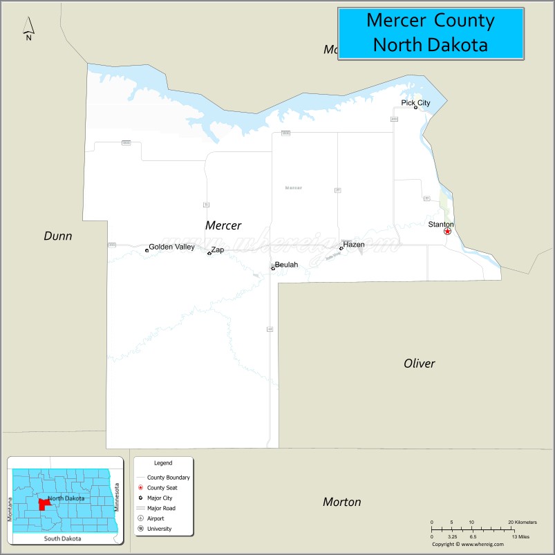
About Mercer County Map, North Dakota: The map showing the county boundary, county seat, major cities, highways, water bodies and neighbouring counties.
More North Dakota Maps & Info
About Mercer County, North Dakota
Mercer County is a county located in the U.S. state of North Dakota. It's county seat is Stanton. As per 2020 census, the population of Mercer County is 8323 people and population density is square miles. According to the United States Census Bureau, the county has a total area of 1,045 sq mi (2,707 km2). Mercer County was established on 1875.
Mercer County Facts
| Continent | North America |
| Country | United States |
| State | North Dakota |
| County Seat | Stanton |
| Largest City/Town | Beulah |
| Established | 1873 (organized 1883) |
| Total Area | 1,121.2 sq mi (2,904.0 sq km) |
| Land Area | 1,043.0 sq mi (2,701.4 sq km) |
| Water Area | 78.2 sq mi (202.6 sq km) |
| Population | 8,350 (Census 2020) |
| Population Density | 8.0 people per sq mi |
| Time Zone | Central Time Zone |
| Major Highways | North Dakota Highway 200, North Dakota Highway 49, North Dakota Highway 1806, North Dakota Highway 200A |
| Major Rivers | Missouri River, Knife River |
| Neighboring Counties | McLean, Oliver, Burleigh, Morton, Dunn, McKenzie |
| Famous For | Coal mining, power generation, Lake Sakakawea, Knife River Indian Villages, and energy production |
| Top Attractions | Knife River Indian Villages National Historic Site, Lake Sakakawea, Beulah Bay Recreation Area, Hazen Golf Club, Dakota Gasification Plant Visitor Area |
| Official Website | Official Website |
About Mercer County, North Dakota
Mercer County is located in west-central North Dakota and was established in 1873. The county seat is Stanton, while Beulah is the largest city. The county is one of North Dakota's leading energy-producing regions, with extensive coal mining operations and power generation facilities. Lake Sakakawea, the Missouri River, and historic Native American sites add significant recreational and cultural value to the area.
Cities and Towns in Mercer County, North Dakota
| City/Town | Population (Census 2020) | Latitude & Longitude |
|---|---|---|
| Stanton (county seat) | 689 | 47.3214°N, 101.3802°W |
| Beulah | 3,319 | 47.2647°N, 101.7779°W |
| Hazen | 2,281 | 47.2947°N, 101.6227°W |
| Golden Valley | 182 | 47.2928°N, 101.9158°W |
| Pick City | 123 | 47.5115°N, 101.4749°W |
| Zap | 221 | 47.2920°N, 101.9234°W |
| Hannover (CDP) | 15 | 47.2290°N, 101.5314°W |
Best Golf Courses in Mercer County, North Dakota
| Golf Course | Location | Latitude & Longitude |
|---|---|---|
| Hazen Golf Club | Hazen | 47.3014°N, 101.6320°W |
| Beulah Country Club | Beulah | 47.2705°N, 101.7878°W |
| Black Sands Golf Course | Beulah | 47.2489°N, 101.7702°W |
What are Major Roads and Highways in Mercer County
Major highways connect the county to nearby regions and cities.
- North Dakota Highway 200 - major east-west route connecting Beulah, Stanton, and surrounding counties
- North Dakota Highway 49 - north-south route serving coal-producing and agricultural areas
- North Dakota Highway 1806 - scenic highway following portions of the Missouri River corridor
- North Dakota Highway 200A - connects communities near Garrison Dam and Lake Sakakawea
- County roads provide access to energy facilities, recreation areas, farms, and ranches
Neighboring Counties of Mercer County
- McLean County (north)
- Oliver County (east)
- Burleigh County (southeast)
- Morton County (south)
- Dunn County (west)
- McKenzie County (northwest)
What are Top Attractions in Mercer County, North Dakota
The county offers a mix of natural and cultural attractions.
| Main Sight Name | City | Famous For |
|---|---|---|
| Knife River Indian Villages National Historic Site | Near Stanton | Historic Hidatsa earthlodge villages and Native American history |
| Lake Sakakawea | Northern County | Boating, fishing, camping, and water recreation |
| Beulah Bay Recreation Area | Beulah | Camping, fishing, and lakeside activities |
| Dakota Gasification Plant Visitor Area | Beulah | Energy production and industrial heritage |
| Hazen Golf Club | Hazen | Golf and outdoor recreation |
| Beulah Country Club | Beulah | Golf and community events |
| Lewis and Clark Trail Sites | Countywide | Historic exploration landmarks |
| Missouri River Scenic Areas | Countywide | Wildlife viewing and photography |
| Lake Sakakawea State Recreation Areas | Northern County | Boating and camping opportunities |
| Coal Country Heritage Sites | Beulah-Hazen Area | Mining history and regional culture |
Distance from Mercer County to Nearby Cities
The following distances are measured by road (driving).
- Stanton to Beulah (Mercer County), North Dakota - 24 mi (39 km)
- Stanton to Hazen (Mercer County), North Dakota - 16 mi (26 km)
- Stanton to Zap (Mercer County), North Dakota - 29 mi (47 km)
- Stanton to Washburn (McLean County), North Dakota - 21 mi (34 km)
- Stanton to Center (Oliver County), North Dakota - 28 mi (45 km)
- Stanton to Mandan (Morton County), North Dakota - 44 mi (71 km)
- Stanton to Bismarck (Burleigh County), North Dakota - 47 mi (76 km)
- Stanton to Killdeer (Dunn County), North Dakota - 63 mi (101 km)
- Stanton to Watford City (McKenzie County), North Dakota - 104 mi (167 km)
- Stanton to Dickinson (Stark County), North Dakota - 88 mi (142 km)
- Stanton to Minot (Ward County), North Dakota - 83 mi (134 km)
- Stanton to Williston (Williams County), North Dakota - 146 mi (235 km)
- Stanton to Jamestown (Stutsman County), North Dakota - 119 mi (191 km)
- Stanton to Fargo (Cass County), North Dakota - 198 mi (319 km)
- Stanton to Grand Forks (Grand Forks County), North Dakota - 225 mi (362 km)
References
- QuickFacts - U.S. Census Bureau
- United States Census Bureau
- United States Geological Survey (USGS)
- National Geodetic Survey
- Official County Website
- Adams County Map
- Barnes County Map
- Benson County Map
- Billings County Map
- Bottineau County Map
- Bowman County Map
- Burke County Map
- Burleigh County Map
- Cass County Map
- Cavalier County Map
- Dickey County Map
- Divide County Map
- Dunn County Map
- Eddy County Map
- Emmons County Map
- Foster County Map
- Golden Valley County Map
- Grand Forks County Map
- Grant County Map
- Griggs County Map
- Hettinger County Map
- Kidder County Map
- LaMoure County Map
- Logan County Map
- McHenry County Map
- McKenzie County Map
- McLean County Map
- McIntosh County Map
- Mercer County Map
- Morton County Map
- Mountrail County Map
- Nelson County Map
- Oliver County Map
- Pembina County Map
- Pierce County Map
- Ramsey County Map
- Ransom County Map
- Renville County Map
- Richland County Map
- Rolette County Map
- Sargent County Map
- Sheridan County Map
- Sioux County Map
- Slope County Map
- Stark County Map
- Steele County Map
- Stutsman County Map
- Towner County Map
- Traill County Map
- Walsh County Map
- Ward County Map
- Wells County Map
- Williams County Map
- Alabama Counties
- Alaska boroughs
- Arizona Counties
- Arkansas Counties
- California County Map
- Colorado Counties
- Connecticut Counties
- Delaware Counties
- Florida County Map
- Georgia County Map
- Hawaii Counties
- Idaho Counties
- Illinois Counties
- Indiana Counties
- Iowa Counties
- Kansas Counties
- Kentucky Counties
- Louisiana Counties
- Maine Counties
- Maryland Counties
- Massachusetts Counties
- Michigan County Map
- Minnesota Counties
- Mississippi Counties
- Missouri Counties
- Montana Counties
- Nebraska Counties
- Nevada Counties
- New York Counties
- New Hampshire Counties
- New Jersey Counties
- New Mexico Counties
- North Carolina Counties
- North Dakota Counties
- Ohio County Map
- Oklahoma Counties
- Oregon Counties
- Pennsylvania Counties
- Rhode Island Counties
- South Carolina Counties
- South Dakota Counties
- Map of Tennessee
- Texas County Map
- Utah Counties
- Vermont Counties
- Virginia Counties
- Washington Counties
- West Virginia Counties
- Wisconsin Counties
- Wyoming Counties