Written and Fact-checked by Whereig Editors | Updated On: May 31, 2026
Map of Sargent County - Sargent County is a county located in the U.S. state of North Dakota. Sargent County Map showing cities, highways, important places and water bodies. Get Where is Sargent County located in the map, major cities in Sargent county, population, areas, and places of interest.
Map of Sargent County, North Dakota
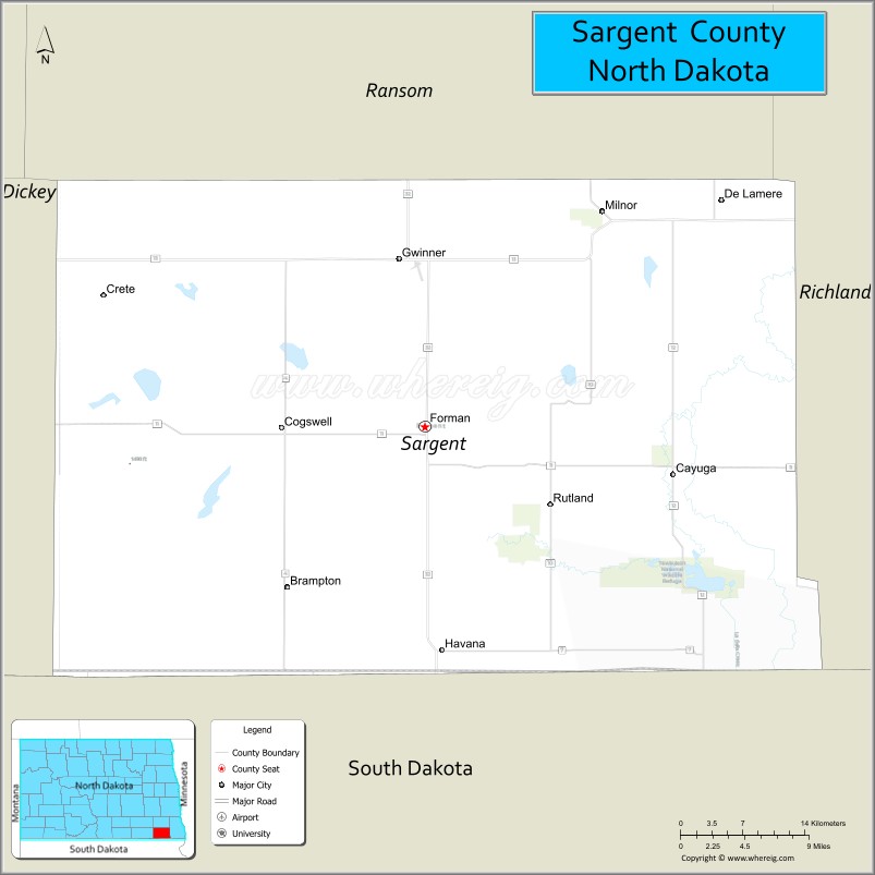
About Sargent County Map, North Dakota: The map showing the county boundary, county seat, major cities, highways, water bodies and neighbouring counties.
More North Dakota Maps & Info
About Sargent County, North Dakota
Sargent County is a county located in the U.S. state of North Dakota. It's county seat is Forman. As per 2020 census, the population of Sargent County is 3829 people and population density is square miles. According to the United States Census Bureau, the county has a total area of 859 sq mi (2,225 km2). Sargent County was established on 1883.
Sargent County Facts
| Continent | North America |
| Country | United States |
| State | North Dakota |
| County Seat | Forman |
| Largest City/Town | Gwinner |
| Established | 1883 |
| Total Area | 866.9 sq mi (2,245.3 sq km) |
| Land Area | 858.5 sq mi (2,223.5 sq km) |
| Water Area | 8.4 sq mi (21.8 sq km) |
| Population | 3,862 (Census 2020) |
| Population Density | 4.5 people per sq mi |
| Time Zone | Central Time Zone |
| Major Highways | North Dakota Highway 11, North Dakota Highway 13, North Dakota Highway 32 |
| Major Rivers | Wild Rice River, Maple River tributaries |
| Neighboring Counties | Barnes, Ransom, Richland, Dickey, LaMoure |
| Famous For | Bobcat Company, agriculture, prairie landscapes, and the historic Sargent County Courthouse |
| Top Attractions | Sargent County Courthouse, Tewaukon National Wildlife Refuge, Silver Lake, Bobcat Company heritage, Fort Ransom region nearby |
| Official Website | Official Website |
About Sargent County, North Dakota
Sargent County is located in southeastern North Dakota and was established in 1883. The county seat is Forman, while Gwinner is the largest city. The county is situated between the James River Valley and Red River Valley and is characterized by fertile farmland, prairie wetlands, and gently rolling terrain. Agriculture and manufacturing remain important parts of the local economy.
Cities and Towns in Sargent County, North Dakota
| City/Town | Population (Census 2020) | Latitude & Longitude |
|---|---|---|
| Forman (county seat) | 509 | 46.1089°N, 97.6362°W |
| Gwinner | 924 | 46.2227°N, 97.6545°W |
| Milnor | 653 | 46.2608°N, 97.4553°W |
| Rutland | 127 | 46.0544°N, 97.4984°W |
| Cogswell | 80 | 46.1455°N, 97.7909°W |
| Cayuga | 40 | 46.0805°N, 97.3855°W |
| Havana | 84 | 45.9844°N, 97.6215°W |
| De Lamere (CDP) | 30 | 46.1948°N, 97.9846°W |
Best Golf Courses in Sargent County, North Dakota
| Golf Course | Location | Latitude & Longitude |
|---|---|---|
| Oakes Golf Club | Near Forman Area | 46.1331°N, 98.0942°W |
| Gwinner Municipal Golf Course | Gwinner | 46.2264°N, 97.6664°W |
| Milnor Golf Course | Milnor | 46.2671°N, 97.4628°W |
What are Major Roads and Highways in Sargent County
Major highways connect the county to nearby regions and cities.
- North Dakota Highway 11 - east-west route connecting Forman, Milnor, and nearby counties
- North Dakota Highway 13 - serves southern portions of the county and connects Havana and Forman with southeastern North Dakota
- North Dakota Highway 32 - major north-south route linking Gwinner, Forman, Lisbon, and Wahpeton
- County roads provide access to farms, recreation areas, and rural communities throughout the county
Neighboring Counties of Sargent County
- Barnes County (north)
- Ransom County (east)
- Richland County (southeast)
- Dickey County (southwest)
- LaMoure County (west)
What are Top Attractions in Sargent County, North Dakota
The county offers a mix of natural and cultural attractions.
| Main Sight Name | City | Famous For |
|---|---|---|
| Sargent County Courthouse | Forman | Historic Beaux Arts courthouse listed on the National Register of Historic Places |
| Tewaukon National Wildlife Refuge | Cayuga Area | Wildlife viewing, birdwatching, and prairie wetlands |
| Silver Lake | Near Forman | Fishing and outdoor recreation |
| Bobcat Company Heritage Site | Gwinner | Original home of the Bobcat Company |
| Milnor Heritage Museum | Milnor | Local history and pioneer exhibits |
| Wild Rice River Valley | Countywide | Scenic prairie landscapes and wildlife habitat |
| Forman City Park | Forman | Community recreation and outdoor activities |
| Rutland Dam Recreation Area | Rutland | Fishing and nature observation |
| Prairie Pothole Region | Countywide | Migratory bird habitat and photography |
| Historic Downtown Gwinner | Gwinner | Small-town charm and local businesses |
Distance from Sargent County to Nearby Cities
The following distances are measured by road (driving).
- Forman to Gwinner (Sargent County), North Dakota - 11 mi (18 km)
- Forman to Milnor (Sargent County), North Dakota - 14 mi (23 km)
- Forman to Rutland (Sargent County), North Dakota - 11 mi (18 km)
- Forman to Lisbon (Ransom County), North Dakota - 37 mi (60 km)
- Forman to Wahpeton (Richland County), North Dakota - 36 mi (58 km)
- Forman to Oakes (Dickey County), North Dakota - 24 mi (39 km)
- Forman to LaMoure (LaMoure County), North Dakota - 44 mi (71 km)
- Forman to Valley City (Barnes County), North Dakota - 59 mi (95 km)
- Forman to Fargo (Cass County), North Dakota - 81 mi (130 km)
- Forman to Jamestown (Stutsman County), North Dakota - 97 mi (156 km)
- Forman to Aberdeen (Brown County), South Dakota - 83 mi (134 km)
- Forman to Grand Forks (Grand Forks County), North Dakota - 165 mi (266 km)
- Forman to Devils Lake (Ramsey County), North Dakota - 171 mi (275 km)
- Forman to Bismarck (Burleigh County), North Dakota - 178 mi (286 km)
- Forman to Minot (Ward County), North Dakota - 243 mi (391 km)
References
- QuickFacts - Sargent County, North Dakota
- United States Census Bureau
- United States Geological Survey (USGS)
- National Geodetic Survey
- Official County Website
- Adams County Map
- Barnes County Map
- Benson County Map
- Billings County Map
- Bottineau County Map
- Bowman County Map
- Burke County Map
- Burleigh County Map
- Cass County Map
- Cavalier County Map
- Dickey County Map
- Divide County Map
- Dunn County Map
- Eddy County Map
- Emmons County Map
- Foster County Map
- Golden Valley County Map
- Grand Forks County Map
- Grant County Map
- Griggs County Map
- Hettinger County Map
- Kidder County Map
- LaMoure County Map
- Logan County Map
- McHenry County Map
- McKenzie County Map
- McLean County Map
- McIntosh County Map
- Mercer County Map
- Morton County Map
- Mountrail County Map
- Nelson County Map
- Oliver County Map
- Pembina County Map
- Pierce County Map
- Ramsey County Map
- Ransom County Map
- Renville County Map
- Richland County Map
- Rolette County Map
- Sargent County Map
- Sheridan County Map
- Sioux County Map
- Slope County Map
- Stark County Map
- Steele County Map
- Stutsman County Map
- Towner County Map
- Traill County Map
- Walsh County Map
- Ward County Map
- Wells County Map
- Williams County Map
- Alabama Counties
- Alaska boroughs
- Arizona Counties
- Arkansas Counties
- California County Map
- Colorado Counties
- Connecticut Counties
- Delaware Counties
- Florida County Map
- Georgia County Map
- Hawaii Counties
- Idaho Counties
- Illinois Counties
- Indiana Counties
- Iowa Counties
- Kansas Counties
- Kentucky Counties
- Louisiana Counties
- Maine Counties
- Maryland Counties
- Massachusetts Counties
- Michigan County Map
- Minnesota Counties
- Mississippi Counties
- Missouri Counties
- Montana Counties
- Nebraska Counties
- Nevada Counties
- New York Counties
- New Hampshire Counties
- New Jersey Counties
- New Mexico Counties
- North Carolina Counties
- North Dakota Counties
- Ohio County Map
- Oklahoma Counties
- Oregon Counties
- Pennsylvania Counties
- Rhode Island Counties
- South Carolina Counties
- South Dakota Counties
- Map of Tennessee
- Texas County Map
- Utah Counties
- Vermont Counties
- Virginia Counties
- Washington Counties
- West Virginia Counties
- Wisconsin Counties
- Wyoming Counties