Written and Fact-checked by Whereig Editors | Updated On: May 31, 2026
Map of Divide County - Divide County is a county located in the U.S. state of North Dakota. Divide County Map showing cities, highways, important places and water bodies. Get Where is Divide County located in the map, major cities in Divide county, population, areas, and places of interest.
Map of Divide County, North Dakota
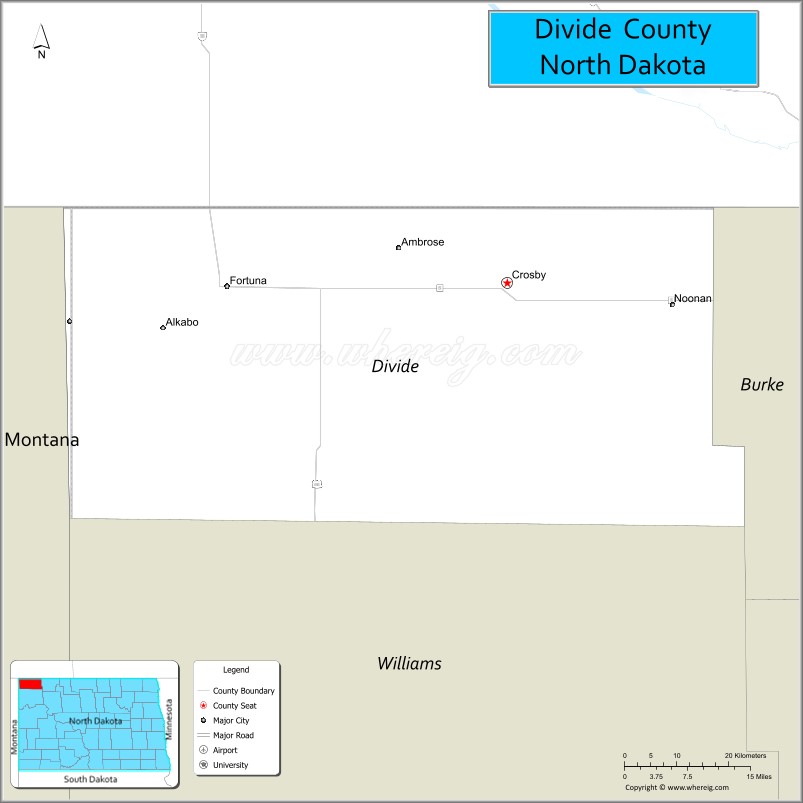
About Divide County Map, North Dakota: The map showing the county boundary, county seat, major cities, highways, water bodies and neighbouring counties.
More North Dakota Maps & Info
About Divide County, North Dakota
Divide County is a county located in the U.S. state of North Dakota. It's county seat is Crosby. As per 2020 census, the population of Divide County is 2188 people and population density is square miles. According to the United States Census Bureau, the county has a total area of 1,259 sq mi (3,261 km2). Divide County was established on 1910.
Divide County Facts
| Continent | North America |
| Country | United States |
| State | North Dakota |
| County Seat | Crosby |
| Largest City/Town | Crosby |
| Established | 1910 |
| Total Area | 1,294.0 sq mi (3,351.4 sq km) |
| Land Area | 1,260.5 sq mi (3,264.7 sq km) |
| Water Area | 33.5 sq mi (86.8 sq km) |
| Population | 2,195 (Census 2020) |
| Population Density | 1.7 people per sq mi |
| Time Zone | Central Time Zone |
| Major Highways | US Highway 85, North Dakota Highway 5, North Dakota Highway 40 |
| Major Rivers | Souris River (Mouse River) |
| Neighboring Counties | Burke, Williams, Mountrail, and Rural Municipalities of Saskatchewan |
| Famous For | Crosby, Lostwood National Wildlife Refuge, prairie wetlands, oil production, and border communities |
| Top Attractions | Lostwood National Wildlife Refuge, Crosby Country Club, Writing Rock State Historic Site, Medicine Lake National Wildlife Refuge |
| Official Website | Official Website |
About Divide County, North Dakota
Divide County is located in the northwestern corner of North Dakota along the Canadian border and was established in 1910. The county seat and largest city is Crosby. The county is characterized by prairie grasslands, wetlands, agricultural land, and oil-producing areas associated with the Williston Basin. Wildlife refuges and outdoor recreation areas make it a popular destination for hunting, birdwatching, and nature enthusiasts.
Cities and Towns in Divide County, North Dakota
| City/Town | Population (Census 2020) | Latitude & Longitude |
|---|---|---|
| Crosby (county seat) | 1,078 | 48.9100°N, 103.2971°W |
| Noonan | 121 | 48.8900°N, 103.0106°W |
| Fortuna | 22 | 48.9106°N, 103.7805°W |
| Ambrose | 26 | 48.9558°N, 103.4772°W |
| Colgan | 12 | 48.8514°N, 103.1263°W |
| Alkabo | 0 | 48.9994°N, 103.5031°W |
| Westby (CDP) | 168 | 48.8630°N, 104.0402°W |
Best Golf Courses in Divide County, North Dakota
| Golf Course | Location | Latitude & Longitude |
|---|---|---|
| Crosby Country Club | Crosby | 48.9153°N, 103.3078°W |
| Noonan Golf Course | Noonan | 48.8915°N, 103.0157°W |
What are Major Roads and Highways in Divide County
Major highways connect the county to nearby regions and cities.
- US Highway 85 - major north-south route connecting Crosby with Williston, Watford City, and Canada
- North Dakota Highway 5 - east-west highway serving northern North Dakota communities
- North Dakota Highway 40 - connects agricultural and energy-producing areas within the county
- County roads provide access to wildlife refuges, ranches, farms, and border communities
Neighboring Counties of Divide County
- Burke County (east)
- Mountrail County (south)
- Williams County (southwest)
- Rural Municipality of Coalfields No. 4, Saskatchewan (north)
- Rural Municipality of Estevan No. 5, Saskatchewan (northeast)
What are Top Attractions in Divide County, North Dakota
The county offers a mix of natural and cultural attractions.
| Main Sight Name | City | Famous For |
|---|---|---|
| Lostwood National Wildlife Refuge | Near Crosby | Prairie wetlands, birdwatching, and wildlife habitat |
| Medicine Lake National Wildlife Refuge | Near Noonan | Migratory birds, wetlands, and outdoor recreation |
| Writing Rock State Historic Site | Near Fortuna | Ancient Indigenous petroglyphs carved into granite boulders |
| Crosby Country Club | Crosby | Golf and community recreation |
| Souris River Valley | Countywide | Scenic landscapes and wildlife viewing |
| Lostwood Lake Area | Near Crosby | Fishing, hunting, and birdwatching |
| Crosby City Park | Crosby | Community recreation and events |
| Divide County Historical Museum | Crosby | Regional history exhibits and pioneer artifacts |
| Prairie Pothole Region | Countywide | Waterfowl habitat and photography opportunities |
| Noonan Border Area | Noonan | International border crossing and regional history |
Distance from Divide County to Nearby Cities
The following distances are measured by road (driving).
- Crosby to Noonan (Divide County), North Dakota - 18 mi (29 km)
- Crosby to Fortuna (Divide County), North Dakota - 28 mi (45 km)
- Crosby to Bowbells (Burke County), North Dakota - 33 mi (53 km)
- Crosby to Stanley (Mountrail County), North Dakota - 67 mi (108 km)
- Crosby to Williston (Williams County), North Dakota - 54 mi (87 km)
- Crosby to Watford City (McKenzie County), North Dakota - 89 mi (143 km)
- Crosby to Minot (Ward County), North Dakota - 124 mi (200 km)
- Crosby to Bottineau (Bottineau County), North Dakota - 116 mi (187 km)
- Crosby to Rugby (Pierce County), North Dakota - 148 mi (238 km)
- Crosby to Bismarck (Burleigh County), North Dakota - 229 mi (369 km)
- Crosby to Fargo (Cass County), North Dakota - 347 mi (558 km)
- Crosby to Estevan, Saskatchewan - 40 mi (64 km)
- Crosby to Weyburn, Saskatchewan - 94 mi (151 km)
- Crosby to Regina, Saskatchewan - 143 mi (230 km)
- Crosby to Grand Forks (Grand Forks County), North Dakota - 282 mi (454 km)
References
- QuickFacts - U.S. Census Bureau
- United States Census Bureau
- United States Geological Survey (USGS)
- National Geodetic Survey
- Official County Website
- Adams County Map
- Barnes County Map
- Benson County Map
- Billings County Map
- Bottineau County Map
- Bowman County Map
- Burke County Map
- Burleigh County Map
- Cass County Map
- Cavalier County Map
- Dickey County Map
- Divide County Map
- Dunn County Map
- Eddy County Map
- Emmons County Map
- Foster County Map
- Golden Valley County Map
- Grand Forks County Map
- Grant County Map
- Griggs County Map
- Hettinger County Map
- Kidder County Map
- LaMoure County Map
- Logan County Map
- McHenry County Map
- McKenzie County Map
- McLean County Map
- McIntosh County Map
- Mercer County Map
- Morton County Map
- Mountrail County Map
- Nelson County Map
- Oliver County Map
- Pembina County Map
- Pierce County Map
- Ramsey County Map
- Ransom County Map
- Renville County Map
- Richland County Map
- Rolette County Map
- Sargent County Map
- Sheridan County Map
- Sioux County Map
- Slope County Map
- Stark County Map
- Steele County Map
- Stutsman County Map
- Towner County Map
- Traill County Map
- Walsh County Map
- Ward County Map
- Wells County Map
- Williams County Map
- Alabama Counties
- Alaska boroughs
- Arizona Counties
- Arkansas Counties
- California County Map
- Colorado Counties
- Connecticut Counties
- Delaware Counties
- Florida County Map
- Georgia County Map
- Hawaii Counties
- Idaho Counties
- Illinois Counties
- Indiana Counties
- Iowa Counties
- Kansas Counties
- Kentucky Counties
- Louisiana Counties
- Maine Counties
- Maryland Counties
- Massachusetts Counties
- Michigan County Map
- Minnesota Counties
- Mississippi Counties
- Missouri Counties
- Montana Counties
- Nebraska Counties
- Nevada Counties
- New York Counties
- New Hampshire Counties
- New Jersey Counties
- New Mexico Counties
- North Carolina Counties
- North Dakota Counties
- Ohio County Map
- Oklahoma Counties
- Oregon Counties
- Pennsylvania Counties
- Rhode Island Counties
- South Carolina Counties
- South Dakota Counties
- Map of Tennessee
- Texas County Map
- Utah Counties
- Vermont Counties
- Virginia Counties
- Washington Counties
- West Virginia Counties
- Wisconsin Counties
- Wyoming Counties