Written and Fact-checked by Whereig Editors | Updated On: May 31, 2026
Map of Bowman County - Bowman County is a county located in the U.S. state of North Dakota. Bowman County Map showing cities, highways, important places and water bodies. Get Where is Bowman County located in the map, major cities in Bowman county, population, areas, and places of interest.
Map of Bowman County, North Dakota
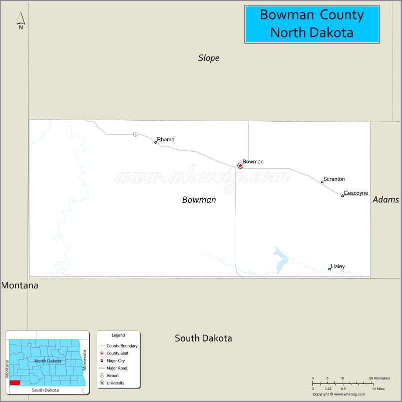
About Bowman County Map, North Dakota: The map showing the county boundary, county seat, major cities, highways, water bodies and neighbouring counties.
More North Dakota Maps & Info
About Bowman County, North Dakota
Bowman County is a county located in the U.S. state of North Dakota. It's county seat is Bowman. As per 2020 census, the population of Bowman County is 2903 people and population density is square miles. According to the United States Census Bureau, the county has a total area of 1,162 sq mi (3,010 km2). Bowman County was established on 1883.
Bowman County Facts
| Continent | North America |
| Country | United States |
| State | North Dakota |
| County Seat | Bowman |
| Largest City/Town | Bowman |
| Established | 1883 (organized 1907) |
| Total Area | 1,167.1 sq mi (3,022.7 sq km) |
| Land Area | 1,161.8 sq mi (3,008.9 sq km) |
| Water Area | 5.2 sq mi (13.5 sq km) |
| Population | 2,993 (Census 2020) |
| Population Density | 2.6 people per sq mi |
| Time Zone | Mountain Time Zone |
| Major Highways | US Highway 12, US Highway 85, North Dakota Highway 67 |
| Major Rivers | Little Missouri River, North Fork Grand River |
| Neighboring Counties | Slope County, Adams County, Harding County (SD), Fallon County (MT) |
| Famous For | Bowman-Haley Lake, ranching, hunting, prairie landscapes, and outdoor recreation |
| Top Attractions | Bowman-Haley Lake, Bowman-Haley Dam, Pioneer Trails Regional Museum, Little Missouri River Valley |
| Official Website | Official Website |
About Bowman County, North Dakota
Bowman County is located in the southwestern corner of North Dakota and was established in 1883. The county seat and largest city is Bowman. The county borders both Montana and South Dakota and features rolling prairie, ranchland, badlands scenery, and several lakes. Agriculture, energy production, tourism, and outdoor recreation play important roles in the local economy.
Cities and Towns in Bowman County, North Dakota
| City/Town | Population (Census 2020) | Latitude & Longitude |
|---|---|---|
| Bowman (county seat) | 1,470 | 46.1835°N, 103.3949°W |
| Rhame | 169 | 46.2344°N, 103.6510°W |
| Scranton | 281 | 46.1467°N, 103.1429°W |
| Gascoyne | 16 | 46.0314°N, 103.0413°W |
Best Golf Courses in Bowman County, North Dakota
| Golf Course | Location | Latitude & Longitude |
|---|---|---|
| Bowman Golf Club | Bowman | 46.1885°N, 103.4056°W |
| Rhame Prairie Golf Course | Rhame | 46.2327°N, 103.6485°W |
What are Major Roads and Highways in Bowman County
Major highways connect the county to nearby regions and cities.
- US Highway 12 - east-west route connecting Bowman with Miles City, Montana and southern North Dakota communities
- US Highway 85 - north-south corridor linking Bowman with Watford City, Belfield, South Dakota, and the Bakken region
- North Dakota Highway 67 - serves rural areas and connects communities within the county
- County road system - provides access to ranches, farms, lakes, and recreation areas throughout the county
Neighboring Counties of Bowman County
- Slope County (north)
- Adams County (east)
- Harding County, South Dakota (south)
- Fallon County, Montana (west)
What are Top Attractions in Bowman County, North Dakota
The county offers a mix of natural and cultural attractions.
| Main Sight Name | City | Famous For |
|---|---|---|
| Bowman-Haley Lake | Near Bowman | Fishing, boating, camping, and water recreation |
| Bowman-Haley Dam | Near Bowman | Reservoir views and outdoor recreation |
| Pioneer Trails Regional Museum | Bowman | Local history, pioneer exhibits, and regional artifacts |
| Bowman Golf Club | Bowman | Public golf course with prairie views |
| Little Missouri River Valley | Western County | Scenic landscapes and wildlife viewing |
| Sunrise Butte Recreation Area | Near Bowman | Hiking and panoramic prairie scenery |
| Bowman County Fairgrounds | Bowman | County fair and agricultural events |
| Rhame Prairie Golf Course | Rhame | Small-town golf and recreation |
| Grand River Grasslands | Southern County | Prairie wildlife and birdwatching |
| Bowman City Park | Bowman | Family recreation and community events |
Distance from Bowman County to Nearby Cities
The following distances are measured by road (driving).
- Bowman to Rhame (Bowman County), North Dakota - 12 mi (19 km)
- Bowman to Scranton (Bowman County), North Dakota - 17 mi (27 km)
- Bowman to Hettinger (Adams County), North Dakota - 33 mi (53 km)
- Bowman to Beach (Golden Valley County), North Dakota - 51 mi (82 km)
- Bowman to Belfield (Stark County), North Dakota - 69 mi (111 km)
- Bowman to Dickinson (Stark County), North Dakota - 83 mi (134 km)
- Bowman to New England (Hettinger County), North Dakota - 52 mi (84 km)
- Bowman to Lemmon (Perkins County), South Dakota - 40 mi (64 km)
- Bowman to Miles City (Custer County), Montana - 95 mi (153 km)
- Bowman to Glendive (Dawson County), Montana - 80 mi (129 km)
- Bowman to Rapid City (Pennington County), South Dakota - 176 mi (283 km)
- Bowman to Bismarck (Burleigh County), North Dakota - 189 mi (304 km)
- Bowman to Minot (Ward County), North Dakota - 220 mi (354 km)
- Bowman to Williston (Williams County), North Dakota - 167 mi (269 km)
- Bowman to Fargo (Cass County), North Dakota - 357 mi (575 km)
References
- QuickFacts - U.S. Census Bureau
- United States Census Bureau
- United States Geological Survey (USGS)
- National Geodetic Survey
- Official County Website
- Adams County Map
- Barnes County Map
- Benson County Map
- Billings County Map
- Bottineau County Map
- Bowman County Map
- Burke County Map
- Burleigh County Map
- Cass County Map
- Cavalier County Map
- Dickey County Map
- Divide County Map
- Dunn County Map
- Eddy County Map
- Emmons County Map
- Foster County Map
- Golden Valley County Map
- Grand Forks County Map
- Grant County Map
- Griggs County Map
- Hettinger County Map
- Kidder County Map
- LaMoure County Map
- Logan County Map
- McHenry County Map
- McKenzie County Map
- McLean County Map
- McIntosh County Map
- Mercer County Map
- Morton County Map
- Mountrail County Map
- Nelson County Map
- Oliver County Map
- Pembina County Map
- Pierce County Map
- Ramsey County Map
- Ransom County Map
- Renville County Map
- Richland County Map
- Rolette County Map
- Sargent County Map
- Sheridan County Map
- Sioux County Map
- Slope County Map
- Stark County Map
- Steele County Map
- Stutsman County Map
- Towner County Map
- Traill County Map
- Walsh County Map
- Ward County Map
- Wells County Map
- Williams County Map
- Alabama Counties
- Alaska boroughs
- Arizona Counties
- Arkansas Counties
- California County Map
- Colorado Counties
- Connecticut Counties
- Delaware Counties
- Florida County Map
- Georgia County Map
- Hawaii Counties
- Idaho Counties
- Illinois Counties
- Indiana Counties
- Iowa Counties
- Kansas Counties
- Kentucky Counties
- Louisiana Counties
- Maine Counties
- Maryland Counties
- Massachusetts Counties
- Michigan County Map
- Minnesota Counties
- Mississippi Counties
- Missouri Counties
- Montana Counties
- Nebraska Counties
- Nevada Counties
- New York Counties
- New Hampshire Counties
- New Jersey Counties
- New Mexico Counties
- North Carolina Counties
- North Dakota Counties
- Ohio County Map
- Oklahoma Counties
- Oregon Counties
- Pennsylvania Counties
- Rhode Island Counties
- South Carolina Counties
- South Dakota Counties
- Map of Tennessee
- Texas County Map
- Utah Counties
- Vermont Counties
- Virginia Counties
- Washington Counties
- West Virginia Counties
- Wisconsin Counties
- Wyoming Counties