Written and Fact-checked by Whereig Editors | Updated On: May 31, 2026
Map of Foster County - Foster County is a county located in the U.S. state of North Dakota. Foster County Map showing cities, highways, important places and water bodies. Get Where is Foster County located in the map, major cities in Foster county, population, areas, and places of interest.
Map of Foster County, North Dakota
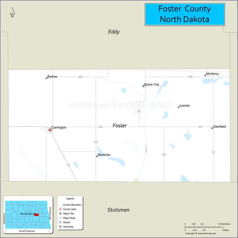
About Foster County Map, North Dakota: The map showing the county boundary, county seat, major cities, highways, water bodies and neighbouring counties.
More North Dakota Maps & Info
About Foster County, North Dakota
Foster County is a county located in the U.S. state of North Dakota. It's county seat is Carrington. As per 2020 census, the population of Foster County is 3364 people and population density is square miles. According to the United States Census Bureau, the county has a total area of 635 sq mi (1,645 km2). Foster County was established on 1873.
Foster County Facts
| Continent | North America |
| Country | United States |
| State | North Dakota |
| County Seat | Carrington |
| Largest City/Town | Carrington |
| Established | 1873 (organized 1883) |
| Total Area | 647.7 sq mi (1,677.5 sq km) |
| Land Area | 635.8 sq mi (1,646.7 sq km) |
| Water Area | 11.9 sq mi (30.8 sq km) |
| Population | 3,397 (Census 2020) |
| Population Density | 5.3 people per sq mi |
| Time Zone | Central Time Zone |
| Major Highways | US Highway 52, US Highway 281, North Dakota Highway 9, North Dakota Highway 200 |
| Major Rivers | James River tributaries, Pipestem Creek |
| Neighboring Counties | Wells, Eddy, Griggs, Stutsman, Kidder |
| Famous For | Carrington, agriculture, North Dakota State University Carrington Research Extension Center, hunting, and prairie wetlands |
| Top Attractions | Carrington City Park, Carrington Research Extension Center, Foster County Museum, Arrowwood National Wildlife Refuge region, CrossRoads Golf Course |
| Official Website | Official Website |
About Foster County, North Dakota
Foster County is located in central North Dakota and was established in 1873. The county seat and largest city is Carrington. The county is situated within a productive agricultural region known for grain farming, ranching, and prairie wetlands. Its central location, transportation connections, and agricultural research facilities make it an important part of North Dakota's farming economy.
Cities and Towns in Foster County, North Dakota
| City/Town | Population (Census 2020) | Latitude & Longitude |
|---|---|---|
| Carrington (county seat) | 2,080 | 47.4497°N, 99.1262°W |
| Glenfield | 94 | 47.4567°N, 98.5632°W |
| Grace City | 57 | 47.5515°N, 98.8270°W |
| McHenry | 56 | 47.5756°N, 98.5868°W |
| Sykeston | 108 | 47.4620°N, 99.4040°W |
| Bordulac | 2 | 47.3549°N, 98.9037°W |
| Juanita | 36 | 47.4703°N, 98.6935°W |
| Bowdon Junction (CDP) | 12 | 47.4728°N, 99.7083°W |
Best Golf Courses in Foster County, North Dakota
| Golf Course | Location | Latitude & Longitude |
|---|---|---|
| CrossRoads Golf Course | Carrington | 47.4528°N, 99.1327°W |
| Carrington Country Club | Carrington | 47.4459°N, 99.1187°W |
What are Major Roads and Highways in Foster County
Major highways connect the county to nearby regions and cities.
- US Highway 52 - major northwest-southeast route connecting Carrington with Jamestown, Minot, and Fargo connections
- US Highway 281 - north-south route linking Carrington with Devils Lake, Jamestown, and South Dakota
- North Dakota Highway 9 - east-west route serving rural communities and agricultural areas
- North Dakota Highway 200 - major state highway crossing northern portions of the county
- County roads provide access to farms, ranches, wetlands, and recreational areas
Neighboring Counties of Foster County
- Eddy County (north)
- Griggs County (east)
- Stutsman County (south)
- Kidder County (southwest)
- Wells County (west)
What are Top Attractions in Foster County, North Dakota
The county offers a mix of natural and cultural attractions.
| Main Sight Name | City | Famous For |
|---|---|---|
| CrossRoads Golf Course | Carrington | Popular public golf course and recreation destination |
| North Dakota State University Carrington Research Extension Center | Carrington | Agricultural research and education facility |
| Foster County Museum | Carrington | Local history exhibits and pioneer collections |
| Carrington City Park | Carrington | Community recreation, playgrounds, and events |
| Arrowwood National Wildlife Refuge Region | Southern County | Birdwatching and wildlife habitat |
| Pipestem Creek Area | Countywide | Fishing and scenic prairie landscapes |
| Carrington Country Club | Carrington | Golf and social events |
| Grace City Park | Grace City | Local recreation and outdoor activities |
| Sykeston Community Park | Sykeston | Community gatherings and recreation |
| Prairie Pothole Wetlands | Countywide | Waterfowl habitat and nature photography |
| James River Basin Landscapes | Countywide | Agricultural scenery and wildlife viewing |
| McHenry Historical Area | McHenry | Small-town history and heritage |
Distance from Foster County to Nearby Cities
The following distances are measured by road (driving).
- Carrington to New Rockford (Eddy County), North Dakota - 30 mi (48 km)
- Carrington to Harvey (Wells County), North Dakota - 31 mi (50 km)
- Carrington to Cooperstown (Griggs County), North Dakota - 37 mi (60 km)
- Carrington to Jamestown (Stutsman County), North Dakota - 43 mi (69 km)
- Carrington to Devils Lake (Ramsey County), North Dakota - 67 mi (108 km)
- Carrington to Steele (Kidder County), North Dakota - 55 mi (89 km)
- Carrington to Valley City (Barnes County), North Dakota - 56 mi (90 km)
- Carrington to Rugby (Pierce County), North Dakota - 64 mi (103 km)
- Carrington to Bismarck (Burleigh County), North Dakota - 95 mi (153 km)
- Carrington to Minot (Ward County), North Dakota - 97 mi (156 km)
- Carrington to Grand Forks (Grand Forks County), North Dakota - 116 mi (187 km)
- Carrington to Fargo (Cass County), North Dakota - 132 mi (212 km)
- Carrington to Wahpeton (Richland County), North Dakota - 160 mi (257 km)
- Carrington to Williston (Williams County), North Dakota - 201 mi (324 km)
- Carrington to Dickinson (Stark County), North Dakota - 169 mi (272 km)
References
- QuickFacts - U.S. Census Bureau
- United States Census Bureau
- United States Geological Survey (USGS)
- National Geodetic Survey
- Official County Website
- Adams County Map
- Barnes County Map
- Benson County Map
- Billings County Map
- Bottineau County Map
- Bowman County Map
- Burke County Map
- Burleigh County Map
- Cass County Map
- Cavalier County Map
- Dickey County Map
- Divide County Map
- Dunn County Map
- Eddy County Map
- Emmons County Map
- Foster County Map
- Golden Valley County Map
- Grand Forks County Map
- Grant County Map
- Griggs County Map
- Hettinger County Map
- Kidder County Map
- LaMoure County Map
- Logan County Map
- McHenry County Map
- McKenzie County Map
- McLean County Map
- McIntosh County Map
- Mercer County Map
- Morton County Map
- Mountrail County Map
- Nelson County Map
- Oliver County Map
- Pembina County Map
- Pierce County Map
- Ramsey County Map
- Ransom County Map
- Renville County Map
- Richland County Map
- Rolette County Map
- Sargent County Map
- Sheridan County Map
- Sioux County Map
- Slope County Map
- Stark County Map
- Steele County Map
- Stutsman County Map
- Towner County Map
- Traill County Map
- Walsh County Map
- Ward County Map
- Wells County Map
- Williams County Map
- Alabama Counties
- Alaska boroughs
- Arizona Counties
- Arkansas Counties
- California County Map
- Colorado Counties
- Connecticut Counties
- Delaware Counties
- Florida County Map
- Georgia County Map
- Hawaii Counties
- Idaho Counties
- Illinois Counties
- Indiana Counties
- Iowa Counties
- Kansas Counties
- Kentucky Counties
- Louisiana Counties
- Maine Counties
- Maryland Counties
- Massachusetts Counties
- Michigan County Map
- Minnesota Counties
- Mississippi Counties
- Missouri Counties
- Montana Counties
- Nebraska Counties
- Nevada Counties
- New York Counties
- New Hampshire Counties
- New Jersey Counties
- New Mexico Counties
- North Carolina Counties
- North Dakota Counties
- Ohio County Map
- Oklahoma Counties
- Oregon Counties
- Pennsylvania Counties
- Rhode Island Counties
- South Carolina Counties
- South Dakota Counties
- Map of Tennessee
- Texas County Map
- Utah Counties
- Vermont Counties
- Virginia Counties
- Washington Counties
- West Virginia Counties
- Wisconsin Counties
- Wyoming Counties