Written and Fact-checked by Whereig Editors | Updated On: May 31, 2026
Map of Morton County - Morton County is a county located in the U.S. state of North Dakota. Morton County Map showing cities, highways, important places and water bodies. Get Where is Morton County located in the map, major cities in Morton county, population, areas, and places of interest.
Map of Morton County, North Dakota
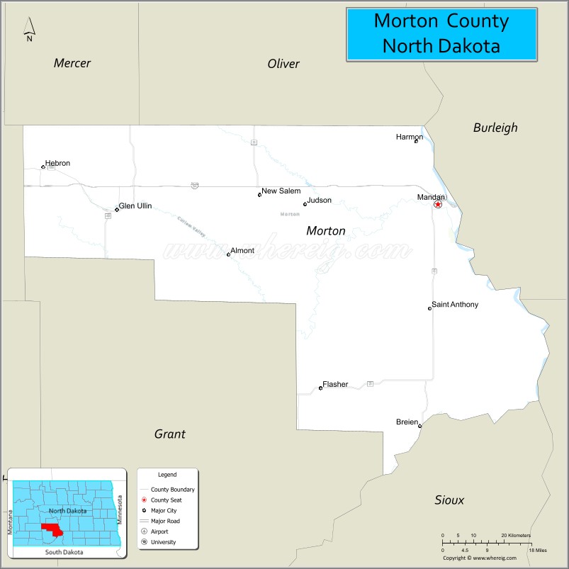
About Morton County Map, North Dakota: The map showing the county boundary, county seat, major cities, highways, water bodies and neighbouring counties.
More North Dakota Maps & Info
About Morton County, North Dakota
Morton County is a county located in the U.S. state of North Dakota. It's county seat is Mandan. As per 2020 census, the population of Morton County is 33611 people and population density is square miles. According to the United States Census Bureau, the county has a total area of 1,926 sq mi (4,988 km2). Morton County was established on 1873.
Morton County Facts
| Continent | North America |
| Country | United States |
| State | North Dakota |
| County Seat | Mandan |
| Largest City/Town | Mandan |
| Established | 1878 |
| Total Area | 1,945.0 sq mi (5,037.5 sq km) |
| Land Area | 1,926.0 sq mi (4,988.3 sq km) |
| Water Area | 19.0 sq mi (49.2 sq km) |
| Population | 33,291 (Census 2020) |
| Population Density | 17.3 people per sq mi |
| Time Zone | Central Time Zone |
| Major Highways | Interstate 94, Interstate 194, US Highway 10, US Highway 83, North Dakota Highway 6, North Dakota Highway 21, North Dakota Highway 1806 |
| Major Rivers | Missouri River, Heart River |
| Neighboring Counties | Oliver, Burleigh, Emmons, Sioux, Grant, Hettinger, Stark, Mercer |
| Famous For | Mandan, Fort Abraham Lincoln State Park, Missouri River, ranching, and Lewis and Clark history |
| Top Attractions | Fort Abraham Lincoln State Park, North Dakota State Railroad Museum, On-A-Slant Indian Village, Missouri River, Huff Indian Village State Historic Site |
| Official Website | Official Website |
About Morton County, North Dakota
Morton County is located in south-central North Dakota and was established in 1878. The county seat and largest city is Mandan. Situated west of the Missouri River across from Bismarck, Morton County combines urban growth with wide-open prairie, agricultural land, and historic sites. The county is one of North Dakota's most populated counties and serves as an important economic and transportation hub.
Cities and Towns in Morton County, North Dakota
| City/Town | Population (Census 2020) | Latitude & Longitude |
|---|---|---|
| Mandan (county seat) | 24,206 | 46.8267°N, 100.8896°W |
| New Salem | 973 | 46.8458°N, 101.4115°W |
| Glen Ullin | 706 | 46.8136°N, 101.8307°W |
| Hebron | 747 | 46.9019°N, 102.0385°W |
| Almont | 122 | 46.7264°N, 101.5054°W |
| Flasher | 221 | 46.4585°N, 101.2251°W |
| New Leipzig (partly) | 221 | 46.3727°N, 101.9443°W |
| St. Anthony | 57 | 46.5938°N, 100.8679°W |
| Sweet Briar (CDP) | 35 | 46.9275°N, 101.5431°W |
| Fort Rice (CDP) | 18 | 46.5078°N, 100.6312°W |
| Huff (CDP) | 28 | 46.4096°N, 100.7317°W |
Best Golf Courses in Morton County, North Dakota
| Golf Course | Location | Latitude & Longitude |
|---|---|---|
| Prairie West Golf Course | Mandan | 46.8531°N, 100.9495°W |
| Mandan Municipal Golf Course | Mandan | 46.8206°N, 100.9013°W |
| Pebble Creek Golf Course | Mandan | 46.8389°N, 100.8631°W |
| Glen Ullin Country Club | Glen Ullin | 46.8128°N, 101.8427°W |
| Heart River Golf Course | Near Mandan | 46.8084°N, 100.9172°W |
What are Major Roads and Highways in Morton County
Major highways connect the county to nearby regions and cities.
- Interstate 94 - major east-west interstate connecting Mandan with Bismarck, Dickinson, Fargo, and Montana
- Interstate 194 - short connector route linking Interstate 94 with Mandan and Bismarck
- US Highway 10 - historic east-west route through Mandan and western Morton County
- US Highway 83 - north-south highway connecting Bismarck-Mandan with central and western North Dakota
- North Dakota Highway 6 - serves southern portions of the county and rural communities
- North Dakota Highway 21 - connects communities in western Morton County
- North Dakota Highway 1806 - scenic route following the Missouri River corridor
Neighboring Counties of Morton County
- Mercer County (northwest)
- Oliver County (north)
- Burleigh County (east)
- Emmons County (southeast)
- Sioux County (south)
- Grant County (southwest)
- Hettinger County (west)
- Stark County (northwest)
What are Top Attractions in Morton County, North Dakota
The county offers a mix of natural and cultural attractions.
| Main Sight Name | City | Famous For |
|---|---|---|
| Fort Abraham Lincoln State Park | Mandan | Historic military fort, Custer House, and outdoor recreation |
| On-A-Slant Indian Village | Mandan | Reconstructed Mandan Native American earthlodge village |
| North Dakota State Railroad Museum | Mandan | Historic railroad exhibits and locomotives |
| Huff Indian Village State Historic Site | Huff | Important archaeological and Native American site |
| Missouri River | Mandan Area | Fishing, boating, and scenic views |
| Fort Rice State Historic Site | Fort Rice | Historic frontier military post |
| Prairie West Golf Course | Mandan | Championship golf and recreation |
| Custer Trail Ranch | Near Mandan | Horseback riding and western experiences |
| Heart River Valley | Countywide | Scenic landscapes and wildlife viewing |
| Crown Butte Dam Recreation Area | Near New Salem | Fishing and camping opportunities |
| Mandan Aquatic Center | Mandan | Family recreation facility |
| Historic Downtown Mandan | Mandan | Shopping, dining, and local events |
Distance from Morton County to Nearby Cities
The following distances are measured by road (driving).
- Mandan to Bismarck (Burleigh County), North Dakota - 7 mi (11 km)
- Mandan to New Salem (Morton County), North Dakota - 30 mi (48 km)
- Mandan to Glen Ullin (Morton County), North Dakota - 58 mi (93 km)
- Mandan to Center (Oliver County), North Dakota - 38 mi (61 km)
- Mandan to Linton (Emmons County), North Dakota - 57 mi (92 km)
- Mandan to Carson (Grant County), North Dakota - 67 mi (108 km)
- Mandan to Mott (Hettinger County), North Dakota - 105 mi (169 km)
- Mandan to Dickinson (Stark County), North Dakota - 99 mi (159 km)
- Mandan to Beulah (Mercer County), North Dakota - 49 mi (79 km)
- Mandan to Jamestown (Stutsman County), North Dakota - 95 mi (153 km)
- Mandan to Minot (Ward County), North Dakota - 111 mi (179 km)
- Mandan to Fargo (Cass County), North Dakota - 196 mi (315 km)
- Mandan to Grand Forks (Grand Forks County), North Dakota - 223 mi (359 km)
- Mandan to Pierre (Hughes County), South Dakota - 190 mi (306 km)
- Mandan to Rapid City (Pennington County), South Dakota - 309 mi (497 km)
References
- QuickFacts - U.S. Census Bureau
- United States Census Bureau
- United States Geological Survey (USGS)
- National Geodetic Survey
- Official County Website
- Adams County Map
- Barnes County Map
- Benson County Map
- Billings County Map
- Bottineau County Map
- Bowman County Map
- Burke County Map
- Burleigh County Map
- Cass County Map
- Cavalier County Map
- Dickey County Map
- Divide County Map
- Dunn County Map
- Eddy County Map
- Emmons County Map
- Foster County Map
- Golden Valley County Map
- Grand Forks County Map
- Grant County Map
- Griggs County Map
- Hettinger County Map
- Kidder County Map
- LaMoure County Map
- Logan County Map
- McHenry County Map
- McKenzie County Map
- McLean County Map
- McIntosh County Map
- Mercer County Map
- Morton County Map
- Mountrail County Map
- Nelson County Map
- Oliver County Map
- Pembina County Map
- Pierce County Map
- Ramsey County Map
- Ransom County Map
- Renville County Map
- Richland County Map
- Rolette County Map
- Sargent County Map
- Sheridan County Map
- Sioux County Map
- Slope County Map
- Stark County Map
- Steele County Map
- Stutsman County Map
- Towner County Map
- Traill County Map
- Walsh County Map
- Ward County Map
- Wells County Map
- Williams County Map
- Alabama Counties
- Alaska boroughs
- Arizona Counties
- Arkansas Counties
- California County Map
- Colorado Counties
- Connecticut Counties
- Delaware Counties
- Florida County Map
- Georgia County Map
- Hawaii Counties
- Idaho Counties
- Illinois Counties
- Indiana Counties
- Iowa Counties
- Kansas Counties
- Kentucky Counties
- Louisiana Counties
- Maine Counties
- Maryland Counties
- Massachusetts Counties
- Michigan County Map
- Minnesota Counties
- Mississippi Counties
- Missouri Counties
- Montana Counties
- Nebraska Counties
- Nevada Counties
- New York Counties
- New Hampshire Counties
- New Jersey Counties
- New Mexico Counties
- North Carolina Counties
- North Dakota Counties
- Ohio County Map
- Oklahoma Counties
- Oregon Counties
- Pennsylvania Counties
- Rhode Island Counties
- South Carolina Counties
- South Dakota Counties
- Map of Tennessee
- Texas County Map
- Utah Counties
- Vermont Counties
- Virginia Counties
- Washington Counties
- West Virginia Counties
- Wisconsin Counties
- Wyoming Counties