Written and Fact-checked by Whereig Editors | Updated On: May 31, 2026
Map of Bottineau County - Bottineau County is a county located in the U.S. state of North Dakota. Bottineau County Map showing cities, highways, important places and water bodies. Get Where is Bottineau County located in the map, major cities in Bottineau county, population, areas, and places of interest.
Map of Bottineau County, North Dakota
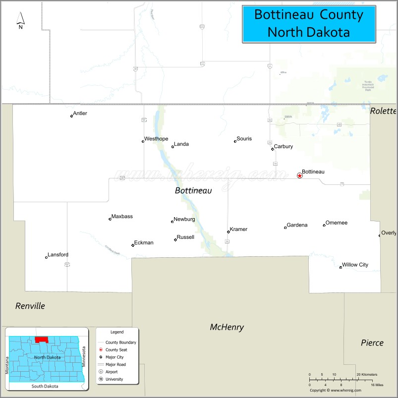
About Bottineau County Map, North Dakota: The map showing the county boundary, county seat, major cities, highways, water bodies and neighbouring counties.
More North Dakota Maps & Info
About Bottineau County, North Dakota
Bottineau County is a county located in the U.S. state of North Dakota. It's county seat is Bottineau. As per 2020 census, the population of Bottineau County is 6390 people and population density is square miles. According to the United States Census Bureau, the county has a total area of 1,669 sq mi (4,323 km2). Bottineau County was established on 1873.
Bottineau County Facts
| Continent | North America |
| Country | United States |
| State | North Dakota |
| County Seat | Bottineau |
| Largest City/Town | Bottineau |
| Established | 1873 (organized 1884) |
| Total Area | 1,697.8 sq mi (4,397.3 sq km) |
| Land Area | 1,668.7 sq mi (4,321.9 sq km) |
| Water Area | 29.1 sq mi (75.4 sq km) |
| Population | 6,379 (Census 2020) |
| Population Density | 3.8 people per sq mi |
| Time Zone | Central Time Zone |
| Major Highways | US Highway 83, North Dakota Highway 5, North Dakota Highway 14, North Dakota Highway 43 |
| Major Rivers | Souris River (Mouse River), Oak Creek |
| Neighboring Counties | Rolette, McHenry, Renville, Towner (ND), and Rural Municipality of Killarney-Turtle Mountain, Manitoba |
| Famous For | Turtle Mountains, Lake Metigoshe State Park, International Peace Garden, winter recreation, and outdoor tourism |
| Top Attractions | International Peace Garden, Lake Metigoshe State Park, Mystical Horizons, Tommy Turtle Monument, Bottineau Winter Park |
| Official Website | Official Website |
About Bottineau County, North Dakota
Bottineau County is located in north-central North Dakota along the Canadian border and was established in 1873. The county seat and largest city is Bottineau. The county is home to the scenic Turtle Mountains, numerous lakes, forests, and recreational areas, making it one of North Dakota's premier destinations for outdoor activities throughout the year.
Cities and Towns in Bottineau County, North Dakota
| City/Town | Population (Census 2020) | Latitude & Longitude |
|---|---|---|
| Bottineau (county seat) | 2,194 | 48.8275°N, 100.4457°W |
| Dunseith | 773 | 48.8131°N, 100.0607°W |
| Bottineau | 2,194 | 48.8275°N, 100.4457°W |
| Westhope | 292 | 48.9102°N, 100.9735°W |
| Willow City | 159 | 48.6047°N, 100.2888°W |
| Newburg | 86 | 48.7236°N, 100.9137°W |
| Kramer | 22 | 48.6867°N, 100.6995°W |
| Lansford | 245 | 48.6289°N, 100.4432°W |
| Landa | 38 | 48.9042°N, 100.7285°W |
| Overly | 12 | 48.6824°N, 100.1515°W |
| Antler | 23 | 48.9707°N, 101.2833°W |
| Bottineau Winter Park (CDP) | 26 | 48.8290°N, 100.5080°W |
Best Golf Courses in Bottineau County, North Dakota
| Golf Course | Location | Latitude & Longitude |
|---|---|---|
| Bottineau Country Club | Bottineau | 48.8298°N, 100.4495°W |
| Lake Metigoshe Golf Course | Near Bottineau | 48.9958°N, 100.3428°W |
What are Major Roads and Highways in Bottineau County
Major highways connect the county to nearby regions and cities.
- US Highway 83 - north-south route connecting Bottineau with Minot and the Canadian border
- North Dakota Highway 5 - east-west route serving northern North Dakota communities
- North Dakota Highway 14 - connects Bottineau with Rugby and central North Dakota
- North Dakota Highway 43 - links the county seat with Lake Metigoshe and recreation areas
- County roads provide access to rural communities, lakes, parks, and border crossings
Neighboring Counties of Bottineau County
- Rolette County (east)
- McHenry County (south)
- Renville County (west)
- Towner County (southeast)
- Rural Municipality of Killarney-Turtle Mountain, Manitoba (north)
What are Top Attractions in Bottineau County, North Dakota
The county offers a mix of natural and cultural attractions.
| Main Sight Name | City | Famous For |
|---|---|---|
| International Peace Garden | Dunseith | International park shared by the United States and Canada |
| Lake Metigoshe State Park | Near Bottineau | Camping, hiking, boating, and fishing |
| Bottineau Winter Park | Bottineau | Skiing, snowboarding, and winter recreation |
| Mystical Horizons | Near Bottineau | Stonehenge-inspired observation site and prairie views |
| Tommy Turtle Monument | Bottineau | Iconic roadside attraction and city landmark |
| Lake Metigoshe | Near Bottineau | Popular boating and fishing destination |
| Turtle Mountain Scenic Byway | Countywide | Scenic driving route through forests and hills |
| Oak Creek Wildlife Management Area | Near Bottineau | Birdwatching and wildlife habitat |
| Bottineau County Museum | Bottineau | Local history exhibits and pioneer artifacts |
| Westhope Wildlife Area | Westhope | Nature viewing and hunting opportunities |
| Turtle Mountains | Countywide | Forested hills unique within North Dakota |
| Lake Upsilon | Near Dunseith | Fishing and outdoor recreation |
Distance from Bottineau County to Nearby Cities
The following distances are measured by road (driving).
- Bottineau to Dunseith (Rolette County), North Dakota - 23 mi (37 km)
- Bottineau to Rugby (Pierce County), North Dakota - 54 mi (87 km)
- Bottineau to Minot (Ward County), North Dakota - 82 mi (132 km)
- Bottineau to Towner (McHenry County), North Dakota - 42 mi (68 km)
- Bottineau to Devils Lake (Ramsey County), North Dakota - 106 mi (171 km)
- Bottineau to Rolla (Rolette County), North Dakota - 49 mi (79 km)
- Bottineau to Mohall (Renville County), North Dakota - 56 mi (90 km)
- Bottineau to Cando (Towner County), North Dakota - 76 mi (122 km)
- Bottineau to Bismarck (Burleigh County), North Dakota - 175 mi (282 km)
- Bottineau to Grand Forks (Grand Forks County), North Dakota - 163 mi (262 km)
- Bottineau to Fargo (Cass County), North Dakota - 257 mi (414 km)
- Bottineau to Winnipeg, Manitoba - 164 mi (264 km)
- Bottineau to Brandon, Manitoba - 128 mi (206 km)
- Bottineau to Williston (Williams County), North Dakota - 162 mi (261 km)
- Bottineau to Jamestown (Stutsman County), North Dakota - 170 mi (274 km)
References
- QuickFacts - U.S. Census Bureau
- United States Census Bureau
- United States Geological Survey (USGS)
- National Geodetic Survey
- Official County Website
- Adams County Map
- Barnes County Map
- Benson County Map
- Billings County Map
- Bottineau County Map
- Bowman County Map
- Burke County Map
- Burleigh County Map
- Cass County Map
- Cavalier County Map
- Dickey County Map
- Divide County Map
- Dunn County Map
- Eddy County Map
- Emmons County Map
- Foster County Map
- Golden Valley County Map
- Grand Forks County Map
- Grant County Map
- Griggs County Map
- Hettinger County Map
- Kidder County Map
- LaMoure County Map
- Logan County Map
- McHenry County Map
- McKenzie County Map
- McLean County Map
- McIntosh County Map
- Mercer County Map
- Morton County Map
- Mountrail County Map
- Nelson County Map
- Oliver County Map
- Pembina County Map
- Pierce County Map
- Ramsey County Map
- Ransom County Map
- Renville County Map
- Richland County Map
- Rolette County Map
- Sargent County Map
- Sheridan County Map
- Sioux County Map
- Slope County Map
- Stark County Map
- Steele County Map
- Stutsman County Map
- Towner County Map
- Traill County Map
- Walsh County Map
- Ward County Map
- Wells County Map
- Williams County Map
- Alabama Counties
- Alaska boroughs
- Arizona Counties
- Arkansas Counties
- California County Map
- Colorado Counties
- Connecticut Counties
- Delaware Counties
- Florida County Map
- Georgia County Map
- Hawaii Counties
- Idaho Counties
- Illinois Counties
- Indiana Counties
- Iowa Counties
- Kansas Counties
- Kentucky Counties
- Louisiana Counties
- Maine Counties
- Maryland Counties
- Massachusetts Counties
- Michigan County Map
- Minnesota Counties
- Mississippi Counties
- Missouri Counties
- Montana Counties
- Nebraska Counties
- Nevada Counties
- New York Counties
- New Hampshire Counties
- New Jersey Counties
- New Mexico Counties
- North Carolina Counties
- North Dakota Counties
- Ohio County Map
- Oklahoma Counties
- Oregon Counties
- Pennsylvania Counties
- Rhode Island Counties
- South Carolina Counties
- South Dakota Counties
- Map of Tennessee
- Texas County Map
- Utah Counties
- Vermont Counties
- Virginia Counties
- Washington Counties
- West Virginia Counties
- Wisconsin Counties
- Wyoming Counties