Written and Fact-checked by Whereig Editors | Updated On: May 31, 2026
Map of Barnes County - Barnes County is a county located in the U.S. state of North Dakota. Barnes County Map showing cities, highways, important places and water bodies. Get Where is Barnes County located in the map, major cities in Barnes county, population, areas, and places of interest.
Map of Barnes County, North Dakota
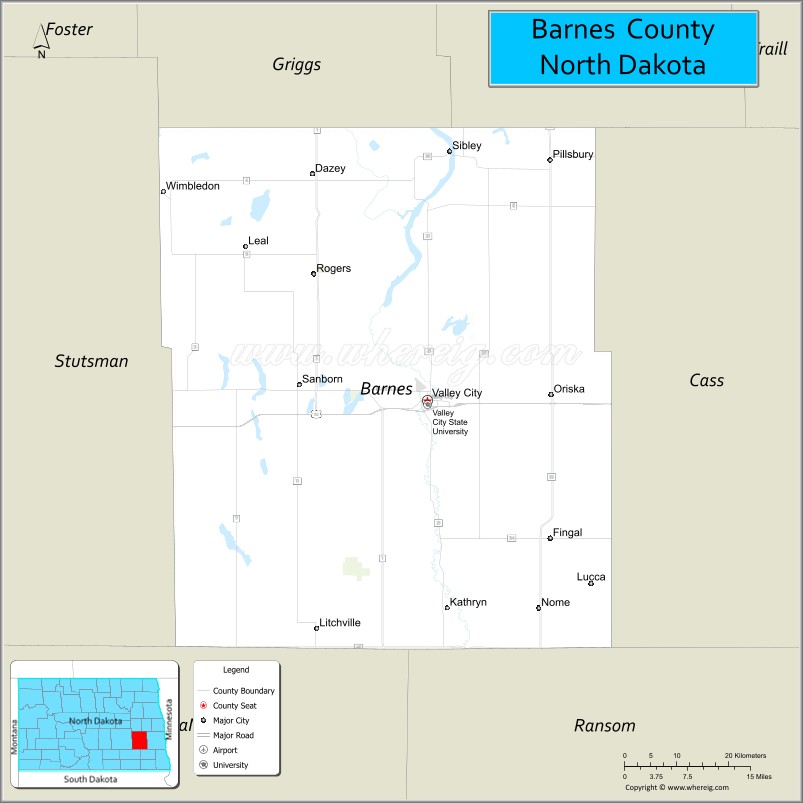
About Barnes County Map, North Dakota: The map showing the county boundary, county seat, major cities, highways, water bodies and neighbouring counties.
More North Dakota Maps & Info
About Barnes County, North Dakota
Barnes County is a county located in the U.S. state of North Dakota. It's county seat is Valley City. As per 2020 census, the population of Barnes County is 10806 people and population density is square miles. According to the United States Census Bureau, the county has a total area of 1,492 sq mi (3,864 km2). Barnes County was established on 1875.
Barnes County Facts
| Continent | North America |
| Country | United States |
| State | North Dakota |
| County Seat | Valley City |
| Largest City/Town | Valley City |
| Established | 1879 |
| Total Area | 1,513.7 sq mi (3,920.5 sq km) |
| Land Area | 1,492.8 sq mi (3,866.4 sq km) |
| Water Area | 20.9 sq mi (54.1 sq km) |
| Population | 10,853 (Census 2020) |
| Population Density | 7.3 people per sq mi |
| Time Zone | Central Time Zone |
| Major Highways | Interstate 94, US Highway 52, North Dakota Highway 1, North Dakota Highway 32 |
| Major Rivers | Sheyenne River |
| Neighboring Counties | Griggs, Steele, Cass, Ransom, LaMoure, Stutsman, Foster |
| Famous For | Hi-Line Railroad Bridge, Valley City, Sheyenne River Valley, agriculture, and North Dakota Winter Show |
| Top Attractions | Hi-Line Railroad Bridge, Medicine Wheel Park, Lake Ashtabula, Baldhill Dam, Sheyenne River Valley Scenic Byway |
| Official Website | Official Website |
About Barnes County, North Dakota
Barnes County is located in southeastern North Dakota and was established in 1879. The county seat is Valley City, which is also the largest city. The county lies within the scenic Sheyenne River Valley and features rolling farmland, lakes, and river bluffs. It serves as an important agricultural region and transportation corridor along Interstate 94.
Cities and Towns in Barnes County, North Dakota
| City/Town | Population (Census 2020) | Latitude & Longitude |
|---|---|---|
| Valley City (county seat) | 6,575 | 46.9233°N, 98.0032°W |
| Kathryn | 52 | 46.6794°N, 97.9759°W |
| Litchville | 172 | 46.6561°N, 98.1967°W |
| Oriska | 114 | 46.9180°N, 97.7929°W |
| Rogers | 43 | 47.1426°N, 98.2009°W |
| Sanborn | 192 | 46.9444°N, 98.2284°W |
| Sibley | 22 | 46.6508°N, 97.8337°W |
| Tower City | 252 | 46.9236°N, 97.6809°W |
| Wimbledon | 216 | 47.1680°N, 98.4626°W |
| Dazey | 21 | 47.1842°N, 98.1184°W |
| Eckelson | 45 | 47.1073°N, 98.7181°W |
| Leal | 17 | 46.9827°N, 98.7609°W |
| Pillsbury | 12 | 47.1918°N, 97.8438°W |
| Clausen Springs (CDP) | 73 | 46.8458°N, 98.0271°W |
Best Golf Courses in Barnes County, North Dakota
| Golf Course | Location | Latitude & Longitude |
|---|---|---|
| Bjornson Park Public Golf Course | Valley City | 46.9128°N, 98.0117°W |
| Valley City Town & Country Club | Valley City | 46.9006°N, 98.0172°W |
What are Major Roads and Highways in Barnes County
Major highways connect the county to nearby regions and cities.
- Interstate 94 - east-west interstate connecting Valley City with Fargo, Jamestown, Bismarck, and Montana
- US Highway 52 - links southeastern North Dakota with Jamestown and surrounding counties
- North Dakota Highway 1 - north-south route serving eastern Barnes County communities
- North Dakota Highway 32 - connects communities in Barnes County with neighboring counties to the north and south
- County road network - provides access to agricultural areas, lakes, and rural communities throughout the county
Neighboring Counties of Barnes County
- Griggs County (north)
- Steele County (northeast)
- Cass County (east)
- Ransom County (southeast)
- LaMoure County (south)
- Stutsman County (west)
- Foster County (northwest)
What are Top Attractions in Barnes County, North Dakota
The county offers a mix of natural and cultural attractions.
| Main Sight Name | City | Famous For |
|---|---|---|
| Hi-Line Railroad Bridge | Valley City | Historic railroad bridge spanning the Sheyenne River Valley |
| Medicine Wheel Park | Valley City | Native American-inspired astronomy and cultural site |
| Lake Ashtabula | Valley City Area | Fishing, boating, camping, and recreation |
| Baldhill Dam | Valley City Area | Flood control structure and scenic overlook |
| Sheyenne River Valley Scenic Byway | Countywide | Scenic driving route through river bluffs and farmland |
| Bjornson Park | Valley City | Large city park with trails and recreation facilities |
| North Dakota Winter Show Event Center | Valley City | Agricultural exhibitions and annual events |
| Barnes County Historical Society Museum | Valley City | Local history exhibits and artifacts |
| Chautauqua Park | Valley City | Historic park and outdoor recreation area |
| Valley City State University Campus | Valley City | Historic university and educational landmark |
| Clausen Springs Recreation Area | Clausen Springs | Camping and outdoor activities |
| Hobart Lake National Wildlife Refuge | Near Valley City | Birdwatching and wildlife habitat |
Distance from Barnes County to Nearby Cities
The following distances are measured by road (driving).
- Valley City to Jamestown (Stutsman County), North Dakota - 37 mi (60 km)
- Valley City to Fargo (Cass County), North Dakota - 58 mi (93 km)
- Valley City to Lisbon (Ransom County), North Dakota - 45 mi (72 km)
- Valley City to Enderlin (Ransom County), North Dakota - 41 mi (66 km)
- Valley City to Tower City (Cass County), North Dakota - 17 mi (27 km)
- Valley City to Cooperstown (Griggs County), North Dakota - 42 mi (68 km)
- Valley City to Carrington (Foster County), North Dakota - 56 mi (90 km)
- Valley City to Oakes (Dickey County), North Dakota - 76 mi (122 km)
- Valley City to Bismarck (Burleigh County), North Dakota - 192 mi (309 km)
- Valley City to Grand Forks (Grand Forks County), North Dakota - 136 mi (219 km)
- Valley City to Wahpeton (Richland County), North Dakota - 77 mi (124 km)
- Valley City to Devils Lake (Ramsey County), North Dakota - 112 mi (180 km)
- Valley City to Minot (Ward County), North Dakota - 179 mi (288 km)
- Valley City to Aberdeen (Brown County), South Dakota - 126 mi (203 km)
- Valley City to Detroit Lakes (Becker County), Minnesota - 93 mi (150 km)
References
- QuickFacts - U.S. Census Bureau
- United States Census Bureau
- United States Geological Survey (USGS)
- National Geodetic Survey
- Official County Website
- Adams County Map
- Barnes County Map
- Benson County Map
- Billings County Map
- Bottineau County Map
- Bowman County Map
- Burke County Map
- Burleigh County Map
- Cass County Map
- Cavalier County Map
- Dickey County Map
- Divide County Map
- Dunn County Map
- Eddy County Map
- Emmons County Map
- Foster County Map
- Golden Valley County Map
- Grand Forks County Map
- Grant County Map
- Griggs County Map
- Hettinger County Map
- Kidder County Map
- LaMoure County Map
- Logan County Map
- McHenry County Map
- McKenzie County Map
- McLean County Map
- McIntosh County Map
- Mercer County Map
- Morton County Map
- Mountrail County Map
- Nelson County Map
- Oliver County Map
- Pembina County Map
- Pierce County Map
- Ramsey County Map
- Ransom County Map
- Renville County Map
- Richland County Map
- Rolette County Map
- Sargent County Map
- Sheridan County Map
- Sioux County Map
- Slope County Map
- Stark County Map
- Steele County Map
- Stutsman County Map
- Towner County Map
- Traill County Map
- Walsh County Map
- Ward County Map
- Wells County Map
- Williams County Map
- Alabama Counties
- Alaska boroughs
- Arizona Counties
- Arkansas Counties
- California County Map
- Colorado Counties
- Connecticut Counties
- Delaware Counties
- Florida County Map
- Georgia County Map
- Hawaii Counties
- Idaho Counties
- Illinois Counties
- Indiana Counties
- Iowa Counties
- Kansas Counties
- Kentucky Counties
- Louisiana Counties
- Maine Counties
- Maryland Counties
- Massachusetts Counties
- Michigan County Map
- Minnesota Counties
- Mississippi Counties
- Missouri Counties
- Montana Counties
- Nebraska Counties
- Nevada Counties
- New York Counties
- New Hampshire Counties
- New Jersey Counties
- New Mexico Counties
- North Carolina Counties
- North Dakota Counties
- Ohio County Map
- Oklahoma Counties
- Oregon Counties
- Pennsylvania Counties
- Rhode Island Counties
- South Carolina Counties
- South Dakota Counties
- Map of Tennessee
- Texas County Map
- Utah Counties
- Vermont Counties
- Virginia Counties
- Washington Counties
- West Virginia Counties
- Wisconsin Counties
- Wyoming Counties