Written and Fact-checked by Whereig Editors | Updated On: May 31, 2026
Map of Burleigh County - Burleigh County is a county located in the U.S. state of North Dakota. Burleigh County Map showing cities, highways, important places and water bodies. Get Where is Burleigh County located in the map, major cities in Burleigh county, population, areas, and places of interest.
Map of Burleigh County, North Dakota
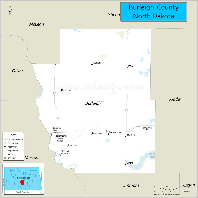
About Burleigh County Map, North Dakota: The map showing the county boundary, county seat, major cities, highways, water bodies and neighbouring counties.
More North Dakota Maps & Info
About Burleigh County, North Dakota
Burleigh County is a county located in the U.S. state of North Dakota. It's county seat is Bismarck. As per 2020 census, the population of Burleigh County is 98933 people and population density is square miles. According to the United States Census Bureau, the county has a total area of 1,633 sq mi (4,229 km2). Burleigh County was established on 1873.
Burleigh County Facts
| Continent | North America |
| Country | United States |
| State | North Dakota |
| County Seat | Bismarck |
| Largest City/Town | Bismarck |
| Established | 1873 |
| Total Area | 1,668.5 sq mi (4,321.4 sq km) |
| Land Area | 1,633.8 sq mi (4,230.9 sq km) |
| Water Area | 34.7 sq mi (89.9 sq km) |
| Population | 98,458 (Census 2020) |
| Population Density | 60.3 people per sq mi |
| Time Zone | Central Time Zone |
| Major Highways | Interstate 94, Interstate 194, US Highway 83, US Highway 10, North Dakota Highway 1804, North Dakota Highway 810 |
| Major Rivers | Missouri River, Heart River |
| Neighboring Counties | McLean, Sheridan, Kidder, Emmons, Morton, Oliver |
| Famous For | North Dakota State Capitol, Bismarck, Missouri River, Fort Abraham Lincoln State Park, and government services |
| Top Attractions | North Dakota State Capitol, Fort Abraham Lincoln State Park, Dakota Zoo, North Dakota Heritage Center & State Museum, Missouri River |
| Official Website | Official Website |
About Burleigh County, North Dakota
Burleigh County is located in south-central North Dakota and was established in 1873. The county seat and largest city is Bismarck, the capital of North Dakota. The county lies along the Missouri River and serves as the political, economic, and cultural center of the state. Its landscape includes rolling prairie, river valleys, agricultural land, and expanding urban development.
Cities and Towns in Burleigh County, North Dakota
| City/Town | Population (Census 2020) | Latitude & Longitude |
|---|---|---|
| Bismarck (county seat) | 73,622 | 46.8083°N, 100.7837°W |
| Lincoln | 4,257 | 46.8047°N, 100.6968°W |
| Wilton | 711 | 47.1631°N, 100.7835°W |
| Regan | 43 | 47.1468°N, 100.4937°W |
| Wing | 152 | 47.1415°N, 100.2832°W |
| Sterling | 62 | 46.8287°N, 100.2796°W |
| Baldwin | 26 | 46.9503°N, 100.7491°W |
| Driscoll | 65 | 46.8952°N, 100.1399°W |
| Menoken (CDP) | 70 | 46.8354°N, 100.5240°W |
| Moffit (CDP) | 101 | 46.6775°N, 100.2869°W |
Best Golf Courses in Burleigh County, North Dakota
| Golf Course | Location | Latitude & Longitude |
|---|---|---|
| Hawktree Golf Club | Bismarck | 46.9016°N, 100.8356°W |
| Bismarck Municipal Golf Course | Bismarck | 46.8159°N, 100.7708°W |
| Tom O'Leary Golf Course | Bismarck | 46.8304°N, 100.8079°W |
| Prairie West Golf Course | Mandan/Bismarck Area | 46.8190°N, 100.9136°W |
| Riverwood Golf Course | Bismarck | 46.7715°N, 100.7424°W |
What are Major Roads and Highways in Burleigh County
Major highways connect the county to nearby regions and cities.
- Interstate 94 - major east-west interstate connecting Bismarck with Fargo, Dickinson, and Montana
- Interstate 194 - urban connector route serving downtown Bismarck
- US Highway 83 - north-south route linking Bismarck with Minot and South Dakota
- US Highway 10 - historic route through the Bismarck metropolitan area
- North Dakota Highway 1804 - scenic route following the Missouri River
- North Dakota Highway 810 - local connector serving Bismarck and nearby communities
Neighboring Counties of Burleigh County
- McLean County (north)
- Sheridan County (northeast)
- Kidder County (east)
- Emmons County (south)
- Morton County (west)
- Oliver County (northwest)
What are Top Attractions in Burleigh County, North Dakota
The county offers a mix of natural and cultural attractions.
| Main Sight Name | City | Famous For |
|---|---|---|
| North Dakota State Capitol | Bismarck | State government headquarters and observation deck |
| North Dakota Heritage Center & State Museum | Bismarck | Largest museum in North Dakota with history exhibits |
| Fort Abraham Lincoln State Park | Bismarck Area | Historic military fort and reconstructed Native American village |
| Dakota Zoo | Bismarck | Popular zoo featuring native and exotic animals |
| Missouri River | Bismarck | Boating, fishing, and scenic riverfront recreation |
| Sertoma Park | Bismarck | Large riverside park with trails and recreation facilities |
| Former Governor's Mansion | Bismarck | Historic residence and museum |
| Keelboat Park | Bismarck | Lewis and Clark heritage site along the river |
| Chief Looking's Village | Bismarck | Historic Native American earthlodge village site |
| McDowell Dam Recreation Area | Bismarck | Fishing, hiking, and outdoor recreation |
| Camp Hancock State Historic Site | Bismarck | Historic frontier military and railroad site |
| Gateway to Science | Bismarck | Interactive science center and educational exhibits |
Distance from Burleigh County to Nearby Cities
The following distances are measured by road (driving).
- Bismarck to Mandan (Morton County), North Dakota - 7 mi (11 km)
- Bismarck to Lincoln (Burleigh County), North Dakota - 5 mi (8 km)
- Bismarck to Wilton (Burleigh County), North Dakota - 24 mi (39 km)
- Bismarck to Washburn (McLean County), North Dakota - 38 mi (61 km)
- Bismarck to Steele (Kidder County), North Dakota - 44 mi (71 km)
- Bismarck to Center (Oliver County), North Dakota - 34 mi (55 km)
- Bismarck to Linton (Emmons County), North Dakota - 57 mi (92 km)
- Bismarck to Beulah (Mercer County), North Dakota - 75 mi (121 km)
- Bismarck to Jamestown (Stutsman County), North Dakota - 95 mi (153 km)
- Bismarck to Dickinson (Stark County), North Dakota - 102 mi (164 km)
- Bismarck to Minot (Ward County), North Dakota - 112 mi (180 km)
- Bismarck to Devils Lake (Ramsey County), North Dakota - 173 mi (278 km)
- Bismarck to Williston (Williams County), North Dakota - 228 mi (367 km)
- Bismarck to Fargo (Cass County), North Dakota - 196 mi (315 km)
- Bismarck to Grand Forks (Grand Forks County), North Dakota - 223 mi (359 km)
References
- QuickFacts - U.S. Census Bureau
- United States Census Bureau
- United States Geological Survey (USGS)
- National Geodetic Survey
- Official County Website
- Adams County Map
- Barnes County Map
- Benson County Map
- Billings County Map
- Bottineau County Map
- Bowman County Map
- Burke County Map
- Burleigh County Map
- Cass County Map
- Cavalier County Map
- Dickey County Map
- Divide County Map
- Dunn County Map
- Eddy County Map
- Emmons County Map
- Foster County Map
- Golden Valley County Map
- Grand Forks County Map
- Grant County Map
- Griggs County Map
- Hettinger County Map
- Kidder County Map
- LaMoure County Map
- Logan County Map
- McHenry County Map
- McKenzie County Map
- McLean County Map
- McIntosh County Map
- Mercer County Map
- Morton County Map
- Mountrail County Map
- Nelson County Map
- Oliver County Map
- Pembina County Map
- Pierce County Map
- Ramsey County Map
- Ransom County Map
- Renville County Map
- Richland County Map
- Rolette County Map
- Sargent County Map
- Sheridan County Map
- Sioux County Map
- Slope County Map
- Stark County Map
- Steele County Map
- Stutsman County Map
- Towner County Map
- Traill County Map
- Walsh County Map
- Ward County Map
- Wells County Map
- Williams County Map
- Alabama Counties
- Alaska boroughs
- Arizona Counties
- Arkansas Counties
- California County Map
- Colorado Counties
- Connecticut Counties
- Delaware Counties
- Florida County Map
- Georgia County Map
- Hawaii Counties
- Idaho Counties
- Illinois Counties
- Indiana Counties
- Iowa Counties
- Kansas Counties
- Kentucky Counties
- Louisiana Counties
- Maine Counties
- Maryland Counties
- Massachusetts Counties
- Michigan County Map
- Minnesota Counties
- Mississippi Counties
- Missouri Counties
- Montana Counties
- Nebraska Counties
- Nevada Counties
- New York Counties
- New Hampshire Counties
- New Jersey Counties
- New Mexico Counties
- North Carolina Counties
- North Dakota Counties
- Ohio County Map
- Oklahoma Counties
- Oregon Counties
- Pennsylvania Counties
- Rhode Island Counties
- South Carolina Counties
- South Dakota Counties
- Map of Tennessee
- Texas County Map
- Utah Counties
- Vermont Counties
- Virginia Counties
- Washington Counties
- West Virginia Counties
- Wisconsin Counties
- Wyoming Counties