Written and Fact-checked by Whereig Editors | Updated On: May 31, 2026
Map of Rolette County - Rolette County is a county located in the U.S. state of North Dakota. Rolette County Map showing cities, highways, important places and water bodies. Get Where is Rolette County located in the map, major cities in Rolette county, population, areas, and places of interest.
Map of Rolette County, North Dakota
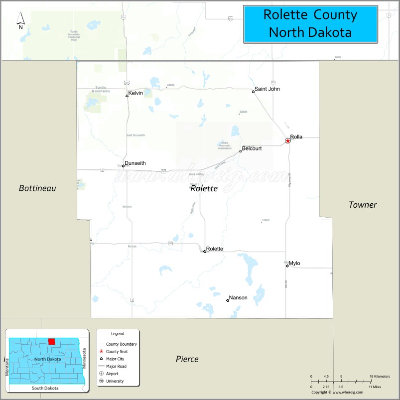
About Rolette County Map, North Dakota: The map showing the county boundary, county seat, major cities, highways, water bodies and neighbouring counties.
More North Dakota Maps & Info
About Rolette County, North Dakota
Rolette County is a county located in the U.S. state of North Dakota. It's county seat is Rolla. As per 2020 census, the population of Rolette County is 12048 people and population density is square miles. According to the United States Census Bureau, the county has a total area of 902 sq mi (2,336 km2). Rolette County was established on 1873.
Rolette County Facts
| Continent | North America |
| Country | United States |
| State | North Dakota |
| County Seat | Rolla |
| Largest City/Town | Rolla |
| Established | 1883 |
| Total Area | 939.0 sq mi (2,432.0 sq km) |
| Land Area | 903.0 sq mi (2,338.8 sq km) |
| Water Area | 36.0 sq mi (93.2 sq km) |
| Population | 12,187 (Census 2020) |
| Population Density | 13.5 people per sq mi |
| Time Zone | Central Time Zone |
| Major Highways | US Highway 281, North Dakota Highway 5, North Dakota Highway 30, North Dakota Highway 66 |
| Major Rivers | Turtle River, Oak Creek |
| Neighboring Counties | Bottineau, Towner, Benson, Pierce, Manitoba (Canada) |
| Famous For | Turtle Mountain Indian Reservation, International Peace Garden region, lakes, outdoor recreation, and Native American heritage |
| Top Attractions | Turtle Mountain Indian Reservation, International Peace Garden vicinity, Carpenter Lake, Lake Upsilon, Rolette County Historical Museum |
| Official Website | Official Website |
About Rolette County, North Dakota
Rolette County is located in north-central North Dakota along the Canadian border and was established in 1883. The county seat and largest city is Rolla. Much of the county lies within the Turtle Mountain Indian Reservation, making Native American culture and history an important part of local life. The area is known for its lakes, wooded hills, wildlife, and outdoor recreation opportunities.
Cities and Towns in Rolette County, North Dakota
| City/Town | Population (Census 2020) | Latitude & Longitude |
|---|---|---|
| Rolla (county seat) | 1,223 | 48.8628°N, 99.6176°W |
| Dunseith | 773 | 48.8139°N, 100.0607°W |
| Rolette | 563 | 48.6617°N, 99.8457°W |
| St. John | 341 | 48.9431°N, 99.7021°W |
| Belcourt (CDP) | 2,491 | 48.8392°N, 99.7449°W |
| East Dunseith (CDP) | 500 | 48.8158°N, 99.9794°W |
| Mylo (CDP) | 20 | 48.6358°N, 99.6174°W |
| Thorne (CDP) | 45 | 48.8285°N, 99.8729°W |
Best Golf Courses in Rolette County, North Dakota
| Golf Course | Location | Latitude & Longitude |
|---|---|---|
| Rolla Country Club | Rolla | 48.8664°N, 99.6287°W |
| Turtle Mountain Golf Course | Belcourt | 48.8398°N, 99.7555°W |
| Dunseith Golf Course | Dunseith | 48.8186°N, 100.0683°W |
What are Major Roads and Highways in Rolette County
Major highways connect the county to nearby regions and cities.
- US Highway 281 - north-south route connecting Dunseith, Belcourt, Rolla, and communities to the south
- North Dakota Highway 5 - major east-west highway crossing the county through Rolla and Dunseith
- North Dakota Highway 30 - connects Rolette with neighboring counties and rural communities
- North Dakota Highway 66 - serves central portions of the Turtle Mountain region
- County roads provide access to lakes, recreation areas, and reservation communities
Neighboring Counties of Rolette County
- Manitoba, Canada (north)
- Towner County (east)
- Benson County (south)
- Pierce County (southwest)
- Bottineau County (west)
What are Top Attractions in Rolette County, North Dakota
The county offers a mix of natural and cultural attractions.
| Main Sight Name | City | Famous For |
|---|---|---|
| Turtle Mountain Indian Reservation | Belcourt | Native American culture, history, and community events |
| Turtle Mountain Heritage Center | Belcourt | Tribal history, artifacts, and cultural exhibits |
| International Peace Garden | Dunseith Area | International park located near the county border |
| Lake Upsilon | Dunseith | Fishing, boating, and camping |
| Carpenter Lake | Belcourt Area | Outdoor recreation and wildlife viewing |
| Rolla Country Club | Rolla | Golf and community recreation |
| Dunseith Historical Museum | Dunseith | Local history and pioneer heritage |
| Mystical Horizons | Dunseith Area | Stone monument and scenic overlook |
| Turtle Mountain State Forest Area | Countywide | Hiking, wildlife, and natural scenery |
| Rolette County Historical Museum | Rolla | County history and cultural exhibits |
| Lake Metigoshe Region | Western County Area | Recreation and scenic landscapes |
| Belcourt Lake Recreation Area | Belcourt | Fishing and family outdoor activities |
Distance from Rolette County to Nearby Cities
The following distances are measured by road (driving).
- Rolla to Belcourt (Rolette County), North Dakota - 9 mi (14 km)
- Rolla to Dunseith (Rolette County), North Dakota - 13 mi (21 km)
- Rolla to Rolette (Rolette County), North Dakota - 16 mi (26 km)
- Rolla to St. John (Rolette County), North Dakota - 10 mi (16 km)
- Rolla to Bottineau (Bottineau County), North Dakota - 31 mi (50 km)
- Rolla to Rugby (Pierce County), North Dakota - 42 mi (68 km)
- Rolla to Cando (Towner County), North Dakota - 38 mi (61 km)
- Rolla to Devils Lake (Ramsey County), North Dakota - 73 mi (117 km)
- Rolla to Minot (Ward County), North Dakota - 96 mi (154 km)
- Rolla to Langdon (Cavalier County), North Dakota - 67 mi (108 km)
- Rolla to New Rockford (Eddy County), North Dakota - 95 mi (153 km)
- Rolla to Grand Forks (Grand Forks County), North Dakota - 137 mi (220 km)
- Rolla to Fargo (Cass County), North Dakota - 219 mi (352 km)
- Rolla to Bismarck (Burleigh County), North Dakota - 183 mi (295 km)
- Rolla to Brandon, Manitoba - 121 mi (195 km)
References
- QuickFacts - U.S. Census Bureau
- United States Census Bureau
- United States Geological Survey (USGS)
- National Geodetic Survey
- Official County Website
- Adams County Map
- Barnes County Map
- Benson County Map
- Billings County Map
- Bottineau County Map
- Bowman County Map
- Burke County Map
- Burleigh County Map
- Cass County Map
- Cavalier County Map
- Dickey County Map
- Divide County Map
- Dunn County Map
- Eddy County Map
- Emmons County Map
- Foster County Map
- Golden Valley County Map
- Grand Forks County Map
- Grant County Map
- Griggs County Map
- Hettinger County Map
- Kidder County Map
- LaMoure County Map
- Logan County Map
- McHenry County Map
- McKenzie County Map
- McLean County Map
- McIntosh County Map
- Mercer County Map
- Morton County Map
- Mountrail County Map
- Nelson County Map
- Oliver County Map
- Pembina County Map
- Pierce County Map
- Ramsey County Map
- Ransom County Map
- Renville County Map
- Richland County Map
- Rolette County Map
- Sargent County Map
- Sheridan County Map
- Sioux County Map
- Slope County Map
- Stark County Map
- Steele County Map
- Stutsman County Map
- Towner County Map
- Traill County Map
- Walsh County Map
- Ward County Map
- Wells County Map
- Williams County Map
- Alabama Counties
- Alaska boroughs
- Arizona Counties
- Arkansas Counties
- California County Map
- Colorado Counties
- Connecticut Counties
- Delaware Counties
- Florida County Map
- Georgia County Map
- Hawaii Counties
- Idaho Counties
- Illinois Counties
- Indiana Counties
- Iowa Counties
- Kansas Counties
- Kentucky Counties
- Louisiana Counties
- Maine Counties
- Maryland Counties
- Massachusetts Counties
- Michigan County Map
- Minnesota Counties
- Mississippi Counties
- Missouri Counties
- Montana Counties
- Nebraska Counties
- Nevada Counties
- New York Counties
- New Hampshire Counties
- New Jersey Counties
- New Mexico Counties
- North Carolina Counties
- North Dakota Counties
- Ohio County Map
- Oklahoma Counties
- Oregon Counties
- Pennsylvania Counties
- Rhode Island Counties
- South Carolina Counties
- South Dakota Counties
- Map of Tennessee
- Texas County Map
- Utah Counties
- Vermont Counties
- Virginia Counties
- Washington Counties
- West Virginia Counties
- Wisconsin Counties
- Wyoming Counties