Written and Fact-checked by Whereig Editors | Updated On: May 31, 2026
Map of Adams County - Adams County is a county located in the U.S. state of North Dakota. Adams County Map showing cities, highways, important places and water bodies. Get Where is Adams County located in the map, major cities in Adams county, population, areas, and places of interest.
Map of Adams County, North Dakota
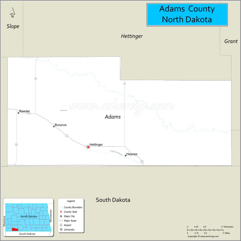
About Adams County Map, North Dakota: The map showing the county boundary, county seat, major cities, highways, water bodies and neighbouring counties.
More North Dakota Maps & Info
About Adams County, North Dakota
Adams County is a county located in the U.S. state of North Dakota. It's county seat is Hettinger. As per 2020 census, the population of Adams County is 2167 people and population density is square miles. According to the United States Census Bureau, the county has a total area of 988 sq mi (2,559 km2). Adams County was established on 1885.
Adams County Facts
| Continent | North America |
| Country | United States |
| State | North Dakota |
| County Seat | Hettinger |
| Largest City/Town | Hettinger |
| Established | 1907 |
| Total Area | 988.7 sq mi (2,560.7 sq km) |
| Land Area | 987.5 sq mi (2,557.8 sq km) |
| Water Area | 1.1 sq mi (2.9 sq km) |
| Population | 2,200 (Census 2020) |
| Population Density | 2.2 people per sq mi |
| Time Zone | Mountain Time Zone |
| Major Highways | US Highway 12, North Dakota Highway 8, North Dakota Highway 22 |
| Major Rivers | No major rivers; Lightning Creek and local tributaries |
| Neighboring Counties | Hettinger, Grant, Sioux, Bowman, Slope, Perkins (SD), Harding (SD), Corson (SD) |
| Famous For | Prairie landscapes, ranching, agriculture, hunting, and scenic badlands terrain |
| Top Attractions | North Lemmon Lake, Adams County Fairgrounds, Hettinger Research Extension Center, Mirror Lake Area |
| Official Website | Official Website |
About Adams County, North Dakota
Adams County is located in the southwestern part of North Dakota and was established in 1907. The county seat is Hettinger, which is also the largest city. The county is characterized by rolling prairie, ranchland, and agricultural fields, while its southern border follows the North Dakota-South Dakota state line. The area is known for cattle ranching, grain farming, and wide-open landscapes.
Cities and Towns in Adams County, North Dakota
| City/Town | Population (Census 2020) | Latitude & Longitude |
|---|---|---|
| Hettinger (county seat) | 1,074 | 46.0017°N, 102.6360°W |
| Reeder | 161 | 46.1139°N, 102.9576°W |
| Haynes | 15 | 45.9687°N, 102.4690°W |
| Bucyrus | 27 | 46.0413°N, 102.7856°W |
| North Lemmon (CDP) | 25 | 45.9435°N, 102.1598°W |
Best Golf Courses in Adams County, North Dakota
| Golf Course | Location | Latitude & Longitude |
|---|---|---|
| Hettinger Country Club Golf Course | Hettinger | 46.0180°N, 102.6400°W |
What are Major Roads and Highways in Adams County
Major highways connect the county to nearby regions and cities.
- US Highway 12 - east-west route connecting Bowman, Hettinger, and communities across southern North Dakota
- North Dakota Highway 8 - north-south route linking Hettinger with Mott and South Dakota
- North Dakota Highway 22 - connects Adams County with Dickinson, Killdeer, and southwestern North Dakota
- County Road Network - provides access to agricultural areas, ranches, and rural communities
Neighboring Counties of Adams County
- Hettinger County (north)
- Grant County (northeast)
- Sioux County (east)
- Corson County, South Dakota (southeast)
- Perkins County, South Dakota (south)
- Harding County, South Dakota (southwest)
- Bowman County (west)
- Slope County (northwest)
What are Top Attractions in Adams County, North Dakota
The county offers a mix of natural and cultural attractions.
| Main Sight Name | City | Famous For |
|---|---|---|
| North Lemmon Lake | North Lemmon | Fishing, boating, and wildlife viewing |
| Mirror Lake | Near Hettinger | Scenic prairie lake and outdoor recreation |
| Hettinger Country Club | Hettinger | Golf and local events |
| Adams County Fairgrounds | Hettinger | County fair and agricultural exhibitions |
| Hettinger Research Extension Center | Hettinger | Agricultural research and education |
| Downtown Hettinger | Hettinger | Historic businesses and local shops |
| Prairie Scenic Byways | Countywide | Open prairie landscapes and photography |
| Wildlife Viewing Areas | Countywide | Waterfowl, deer, and prairie wildlife |
| Rural Ranchlands | Countywide | Classic western North Dakota scenery |
| Hunting Areas | Countywide | Pheasant, deer, and upland game hunting |
Distance from Adams County to Nearby Cities
The following distances are measured by road (driving).
- Hettinger to Mott (Hettinger County), North Dakota - 28 mi (45 km)
- Hettinger to Bowman (Bowman County), North Dakota - 33 mi (53 km)
- Hettinger to New England (Hettinger County), North Dakota - 42 mi (68 km)
- Hettinger to Lemmon (Perkins County), South Dakota - 27 mi (43 km)
- Hettinger to Reeder (Adams County), North Dakota - 13 mi (21 km)
- Hettinger to Dickinson (Stark County), North Dakota - 73 mi (117 km)
- Hettinger to Bismarck (Burleigh County), North Dakota - 170 mi (274 km)
- Hettinger to Rapid City (Pennington County), South Dakota - 157 mi (253 km)
- Hettinger to Hettinger Research Center Area - 4 mi (6 km)
- Hettinger to Fargo (Cass County), North Dakota - 332 mi (534 km)
- Hettinger to Minot (Ward County), North Dakota - 233 mi (375 km)
- Hettinger to Pierre (Hughes County), South Dakota - 150 mi (241 km)
References
- QuickFacts - U.S. Census Bureau
- United States Census Bureau
- United States Geological Survey (USGS)
- National Geodetic Survey
- Official County Website
- Adams County Map
- Barnes County Map
- Benson County Map
- Billings County Map
- Bottineau County Map
- Bowman County Map
- Burke County Map
- Burleigh County Map
- Cass County Map
- Cavalier County Map
- Dickey County Map
- Divide County Map
- Dunn County Map
- Eddy County Map
- Emmons County Map
- Foster County Map
- Golden Valley County Map
- Grand Forks County Map
- Grant County Map
- Griggs County Map
- Hettinger County Map
- Kidder County Map
- LaMoure County Map
- Logan County Map
- McHenry County Map
- McKenzie County Map
- McLean County Map
- McIntosh County Map
- Mercer County Map
- Morton County Map
- Mountrail County Map
- Nelson County Map
- Oliver County Map
- Pembina County Map
- Pierce County Map
- Ramsey County Map
- Ransom County Map
- Renville County Map
- Richland County Map
- Rolette County Map
- Sargent County Map
- Sheridan County Map
- Sioux County Map
- Slope County Map
- Stark County Map
- Steele County Map
- Stutsman County Map
- Towner County Map
- Traill County Map
- Walsh County Map
- Ward County Map
- Wells County Map
- Williams County Map
- Alabama Counties
- Alaska boroughs
- Arizona Counties
- Arkansas Counties
- California County Map
- Colorado Counties
- Connecticut Counties
- Delaware Counties
- Florida County Map
- Georgia County Map
- Hawaii Counties
- Idaho Counties
- Illinois Counties
- Indiana Counties
- Iowa Counties
- Kansas Counties
- Kentucky Counties
- Louisiana Counties
- Maine Counties
- Maryland Counties
- Massachusetts Counties
- Michigan County Map
- Minnesota Counties
- Mississippi Counties
- Missouri Counties
- Montana Counties
- Nebraska Counties
- Nevada Counties
- New York Counties
- New Hampshire Counties
- New Jersey Counties
- New Mexico Counties
- North Carolina Counties
- North Dakota Counties
- Ohio County Map
- Oklahoma Counties
- Oregon Counties
- Pennsylvania Counties
- Rhode Island Counties
- South Carolina Counties
- South Dakota Counties
- Map of Tennessee
- Texas County Map
- Utah Counties
- Vermont Counties
- Virginia Counties
- Washington Counties
- West Virginia Counties
- Wisconsin Counties
- Wyoming Counties
