Written and Fact-checked by Whereig Editors | Updated On: May 31, 2026
Map of Renville County - Renville County is a county located in the U.S. state of North Dakota. Renville County Map showing cities, highways, important places and water bodies. Get Where is Renville County located in the map, major cities in Renville county, population, areas, and places of interest.
Map of Renville County, North Dakota
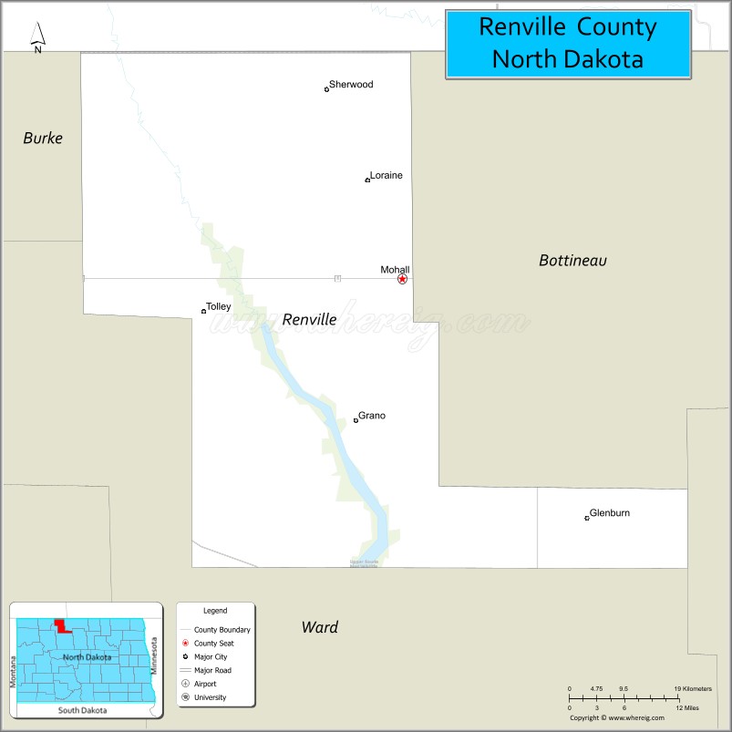
About Renville County Map, North Dakota: The map showing the county boundary, county seat, major cities, highways, water bodies and neighbouring counties.
More North Dakota Maps & Info
About Renville County, North Dakota
Renville County is a county located in the U.S. state of North Dakota. It's county seat is Mohall. As per 2020 census, the population of Renville County is 2266 people and population density is square miles. According to the United States Census Bureau, the county has a total area of 875 sq mi (2,266 km2). Renville County was established on 1873.
Renville County Facts
| Continent | North America |
| Country | United States |
| State | North Dakota |
| County Seat | Mohall |
| Largest City/Town | Mohall |
| Established | 1873 (organized 1910) |
| Total Area | 892.9 sq mi (2,312.6 sq km) |
| Land Area | 877.2 sq mi (2,272.0 sq km) |
| Water Area | 15.7 sq mi (40.6 sq km) |
| Population | 2,282 (Census 2020) |
| Population Density | 2.6 people per sq mi |
| Time Zone | Central Time Zone |
| Major Highways | US Highway 52, US Highway 83, North Dakota Highway 5, North Dakota Highway 28 |
| Major Rivers | Souris River (Mouse River) |
| Neighboring Counties | Burke County, Bottineau County, McHenry County, Ward County, Argyle No. 1 (Saskatchewan), Mount Pleasant No. 2 (Saskatchewan) |
| Famous For | Upper Souris National Wildlife Refuge, Lake Darling, agriculture, border region history, and outdoor recreation |
| Top Attractions | Upper Souris National Wildlife Refuge, Lake Darling, Renville County Courthouse, Mouse River Valley, Des Lacs National Wildlife Refuge nearby |
| Official Website | Official Website |
About Renville County, North Dakota
Renville County is located in northwestern North Dakota along the Canadian border and was established in 1873. The county seat and largest city is Mohall. The county is characterized by rolling prairie, productive farmland, wetlands, and the Souris River valley. Outdoor recreation, farming, wildlife conservation, and cross-border commerce contribute to the county's economy and identity.
Cities and Towns in Renville County, North Dakota
| City/Town | Population (Census 2020) | Latitude & Longitude |
|---|---|---|
| Mohall (county seat) | 694 | 48.7631°N, 101.5136°W |
| Glenburn | 404 | 48.5147°N, 101.2208°W |
| Sherwood | 194 | 48.6906°N, 101.6272°W |
| Tolley | 41 | 48.7531°N, 101.8278°W |
| Loraine | 12 | 48.8575°N, 101.5594°W |
| Grano | 7 | 48.6281°N, 101.6377°W |
Best Golf Courses in Renville County, North Dakota
| Golf Course | Location | Latitude & Longitude |
|---|---|---|
| Mohall Country Club | Mohall | 48.7584°N, 101.5272°W |
| Sherwood Community Golf Course | Sherwood | 48.6937°N, 101.6391°W |
What are Major Roads and Highways in Renville County
Major highways connect the county to nearby regions and cities.
- US Highway 52 - east-west route connecting Mohall with Minot and the Canadian border region
- US Highway 83 - major north-south highway linking the county with Minot and central North Dakota
- North Dakota Highway 5 - northern corridor serving Mohall, Sherwood, and border communities
- North Dakota Highway 28 - connects southern areas of the county with Minot and surrounding agricultural regions
- County roads provide access to farms, wildlife refuges, lakes, and rural communities
Neighboring Counties of Renville County
- Bottineau County (east)
- McHenry County (southeast)
- Ward County (south)
- Burke County (west)
- Argyle No. 1, Saskatchewan (north)
- Mount Pleasant No. 2, Saskatchewan (northwest)
What are Top Attractions in Renville County, North Dakota
The county offers a mix of natural and cultural attractions.
| Main Sight Name | City | Famous For |
|---|---|---|
| Upper Souris National Wildlife Refuge | Near Mohall | Wildlife viewing, birdwatching, and wetlands |
| Lake Darling | Near Tolley | Fishing, boating, and camping |
| Renville County Courthouse | Mohall | Historic county landmark built in the 1930s |
| Souris River Valley | Countywide | Scenic prairie landscapes and wildlife habitat |
| Mohall Country Club | Mohall | Golf and outdoor recreation |
| Sherwood Port of Entry | Sherwood | International border crossing with Canada |
| Lake Darling Dam | Near Tolley | Water management and recreation area |
| Upper Souris Refuge Auto Tour | Near Mohall | Wildlife photography and scenic drives |
| Historic Downtown Mohall | Mohall | Local shops and community heritage |
| Prairie Pothole Region | Countywide | Migratory bird habitat and hunting opportunities |
Distance from Renville County to Nearby Cities
The following distances are measured by road (driving).
- Mohall to Sherwood (Renville County), North Dakota - 8 mi (13 km)
- Mohall to Tolley (Renville County), North Dakota - 18 mi (29 km)
- Mohall to Glenburn (Renville County), North Dakota - 25 mi (40 km)
- Mohall to Bowbells (Burke County), North Dakota - 34 mi (55 km)
- Mohall to Bottineau (Bottineau County), North Dakota - 38 mi (61 km)
- Mohall to Towner (McHenry County), North Dakota - 42 mi (68 km)
- Mohall to Minot (Ward County), North Dakota - 55 mi (89 km)
- Mohall to Stanley (Mountrail County), North Dakota - 74 mi (119 km)
- Mohall to Rugby (Pierce County), North Dakota - 95 mi (153 km)
- Mohall to Williston (Williams County), North Dakota - 110 mi (177 km)
- Mohall to Devils Lake (Ramsey County), North Dakota - 147 mi (237 km)
- Mohall to Bismarck (Burleigh County), North Dakota - 168 mi (270 km)
- Mohall to Grand Forks (Grand Forks County), North Dakota - 221 mi (356 km)
- Mohall to Fargo (Cass County), North Dakota - 294 mi (473 km)
- Mohall to Regina, Saskatchewan - 158 mi (254 km)
References
- QuickFacts - U.S. Census Bureau
- United States Census Bureau
- United States Geological Survey (USGS)
- National Geodetic Survey
- Official County Website
- Adams County Map
- Barnes County Map
- Benson County Map
- Billings County Map
- Bottineau County Map
- Bowman County Map
- Burke County Map
- Burleigh County Map
- Cass County Map
- Cavalier County Map
- Dickey County Map
- Divide County Map
- Dunn County Map
- Eddy County Map
- Emmons County Map
- Foster County Map
- Golden Valley County Map
- Grand Forks County Map
- Grant County Map
- Griggs County Map
- Hettinger County Map
- Kidder County Map
- LaMoure County Map
- Logan County Map
- McHenry County Map
- McKenzie County Map
- McLean County Map
- McIntosh County Map
- Mercer County Map
- Morton County Map
- Mountrail County Map
- Nelson County Map
- Oliver County Map
- Pembina County Map
- Pierce County Map
- Ramsey County Map
- Ransom County Map
- Renville County Map
- Richland County Map
- Rolette County Map
- Sargent County Map
- Sheridan County Map
- Sioux County Map
- Slope County Map
- Stark County Map
- Steele County Map
- Stutsman County Map
- Towner County Map
- Traill County Map
- Walsh County Map
- Ward County Map
- Wells County Map
- Williams County Map
- Alabama Counties
- Alaska boroughs
- Arizona Counties
- Arkansas Counties
- California County Map
- Colorado Counties
- Connecticut Counties
- Delaware Counties
- Florida County Map
- Georgia County Map
- Hawaii Counties
- Idaho Counties
- Illinois Counties
- Indiana Counties
- Iowa Counties
- Kansas Counties
- Kentucky Counties
- Louisiana Counties
- Maine Counties
- Maryland Counties
- Massachusetts Counties
- Michigan County Map
- Minnesota Counties
- Mississippi Counties
- Missouri Counties
- Montana Counties
- Nebraska Counties
- Nevada Counties
- New York Counties
- New Hampshire Counties
- New Jersey Counties
- New Mexico Counties
- North Carolina Counties
- North Dakota Counties
- Ohio County Map
- Oklahoma Counties
- Oregon Counties
- Pennsylvania Counties
- Rhode Island Counties
- South Carolina Counties
- South Dakota Counties
- Map of Tennessee
- Texas County Map
- Utah Counties
- Vermont Counties
- Virginia Counties
- Washington Counties
- West Virginia Counties
- Wisconsin Counties
- Wyoming Counties