Written and Fact-checked by Whereig Editors | Updated On: May 31, 2026
Map of Burke County - Burke County is a county located in the U.S. state of North Dakota. Burke County Map showing cities, highways, important places and water bodies. Get Where is Burke County located in the map, major cities in Burke county, population, areas, and places of interest.
Map of Burke County, North Dakota
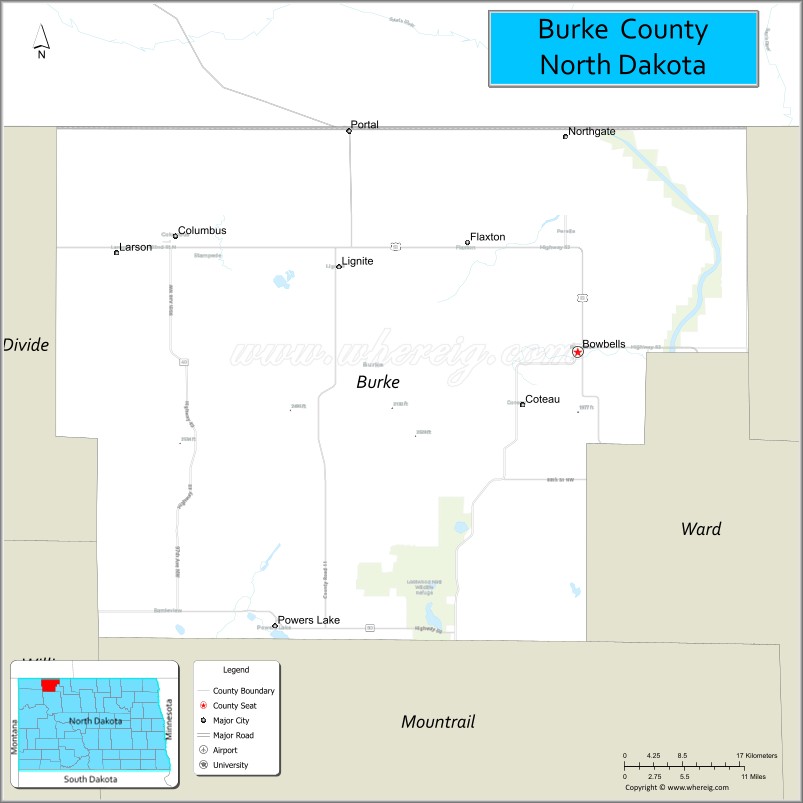
About Burke County Map, North Dakota: The map showing the county boundary, county seat, major cities, highways, water bodies and neighbouring counties.
More North Dakota Maps & Info
About Burke County, North Dakota
Burke County is a county located in the U.S. state of North Dakota. It's county seat is Bowbells. As per 2020 census, the population of Burke County is 2158 people and population density is square miles. According to the United States Census Bureau, the county has a total area of 1,104 sq mi (2,859 km2). Burke County was established on 1910.
Burke County Facts
| Continent | North America |
| Country | United States |
| State | North Dakota |
| County Seat | Bowbells |
| Largest City/Town | Bowbells |
| Established | 1910 |
| Total Area | 1,129.6 sq mi (2,925.7 sq km) |
| Land Area | 1,104.8 sq mi (2,861.4 sq km) |
| Water Area | 24.8 sq mi (64.3 sq km) |
| Population | 2,196 (Census 2020) |
| Population Density | 2.0 people per sq mi |
| Time Zone | Central Time Zone |
| Major Highways | US Highway 52, North Dakota Highway 5, North Dakota Highway 8, North Dakota Highway 50 |
| Major Rivers | Des Lacs River, White Earth River |
| Neighboring Counties | Divide, Renville, Mountrail, Ward, and Rural Municipality of Estevan (Saskatchewan) |
| Famous For | Prairie pothole wetlands, agriculture, hunting, birdwatching, and proximity to the Canadian border |
| Top Attractions | Des Lacs National Wildlife Refuge, Lostwood National Wildlife Refuge, Burke County Museum, Powers Lake Recreation Area |
| Official Website | Official Website |
About Burke County, North Dakota
Burke County is located in northwestern North Dakota along the Canadian border and was established in 1910. The county seat is Bowbells, which is also the largest city. The county consists largely of prairie farmland, wetlands, and wildlife habitat, making it an important agricultural region and a popular destination for waterfowl hunting and outdoor recreation.
Cities and Towns in Burke County, North Dakota
| City/Town | Population (Census 2020) | Latitude & Longitude |
|---|---|---|
| Bowbells (county seat) | 315 | 48.8036°N, 102.2463°W |
| Powers Lake | 381 | 48.5669°N, 102.6444°W |
| Portal | 128 | 48.9950°N, 102.5485°W |
| Flaxton | 66 | 48.9075°N, 102.3938°W |
| Lignite | 136 | 48.8131°N, 102.5665°W |
| Columbus | 133 | 48.9014°N, 102.7807°W |
| Northgate | 22 | 48.9972°N, 102.2413°W |
| Coteau | 16 | 48.7348°N, 102.5857°W |
| Battleview (CDP) | 17 | 48.9917°N, 102.6306°W |
Best Golf Courses in Burke County, North Dakota
| Golf Course | Location | Latitude & Longitude |
|---|---|---|
| Powers Lake Golf Club | Powers Lake | 48.5677°N, 102.6488°W |
| Bowbells Country Club Golf Course | Bowbells | 48.8062°N, 102.2521°W |
What are Major Roads and Highways in Burke County
Major highways connect the county to nearby regions and cities.
- US Highway 52 - east-west route connecting Burke County with Minot, Williston, and the Canadian border crossing at Portal
- North Dakota Highway 5 - serves communities along the northern portion of the county
- North Dakota Highway 8 - north-south route connecting Powers Lake, Stanley, and southern North Dakota
- North Dakota Highway 50 - links Bowbells with surrounding agricultural communities
- County roads provide access to wildlife refuges, farms, ranches, and border communities
Neighboring Counties of Burke County
- Divide County (west)
- Renville County (east)
- Ward County (southeast)
- Mountrail County (south)
- Rural Municipality of Estevan, Saskatchewan (north)
What are Top Attractions in Burke County, North Dakota
The county offers a mix of natural and cultural attractions.
| Main Sight Name | City | Famous For |
|---|---|---|
| Lostwood National Wildlife Refuge | Near Powers Lake | Prairie wetlands, birdwatching, and wildlife habitat |
| Des Lacs National Wildlife Refuge | Eastern County | Migratory birds, scenic wetlands, and nature observation |
| Powers Lake | Powers Lake | Fishing, boating, camping, and recreation |
| Burke County Museum | Bowbells | Local history exhibits and pioneer artifacts |
| Portal International Border Crossing | Portal | Major gateway between North Dakota and Saskatchewan |
| Lostwood Lake | Near Powers Lake | Wildlife viewing and fishing opportunities |
| Bowbells City Park | Bowbells | Community events and recreation |
| Powers Lake Recreation Area | Powers Lake | Outdoor activities and camping |
| Prairie Pothole Region | Countywide | Important waterfowl habitat and hunting area |
| Lignite Historic Area | Lignite | Coal mining heritage and local history |
Distance from Burke County to Nearby Cities
The following distances are measured by road (driving).
- Bowbells to Powers Lake (Burke County), North Dakota - 21 mi (34 km)
- Bowbells to Portal (Burke County), North Dakota - 26 mi (42 km)
- Bowbells to Columbus (Burke County), North Dakota - 33 mi (53 km)
- Bowbells to Crosby (Divide County), North Dakota - 33 mi (53 km)
- Bowbells to Mohall (Renville County), North Dakota - 31 mi (50 km)
- Bowbells to Stanley (Mountrail County), North Dakota - 48 mi (77 km)
- Bowbells to Minot (Ward County), North Dakota - 92 mi (148 km)
- Bowbells to Williston (Williams County), North Dakota - 88 mi (142 km)
- Bowbells to Bottineau (Bottineau County), North Dakota - 83 mi (134 km)
- Bowbells to Rugby (Pierce County), North Dakota - 116 mi (187 km)
- Bowbells to Bismarck (Burleigh County), North Dakota - 197 mi (317 km)
- Bowbells to Estevan, Saskatchewan - 29 mi (47 km)
- Bowbells to Weyburn, Saskatchewan - 83 mi (134 km)
- Bowbells to Fargo (Cass County), North Dakota - 315 mi (507 km)
- Bowbells to Grand Forks (Grand Forks County), North Dakota - 250 mi (402 km)
References
- QuickFacts - U.S. Census Bureau
- United States Census Bureau
- United States Geological Survey (USGS)
- National Geodetic Survey
- Official County Website
- Adams County Map
- Barnes County Map
- Benson County Map
- Billings County Map
- Bottineau County Map
- Bowman County Map
- Burke County Map
- Burleigh County Map
- Cass County Map
- Cavalier County Map
- Dickey County Map
- Divide County Map
- Dunn County Map
- Eddy County Map
- Emmons County Map
- Foster County Map
- Golden Valley County Map
- Grand Forks County Map
- Grant County Map
- Griggs County Map
- Hettinger County Map
- Kidder County Map
- LaMoure County Map
- Logan County Map
- McHenry County Map
- McKenzie County Map
- McLean County Map
- McIntosh County Map
- Mercer County Map
- Morton County Map
- Mountrail County Map
- Nelson County Map
- Oliver County Map
- Pembina County Map
- Pierce County Map
- Ramsey County Map
- Ransom County Map
- Renville County Map
- Richland County Map
- Rolette County Map
- Sargent County Map
- Sheridan County Map
- Sioux County Map
- Slope County Map
- Stark County Map
- Steele County Map
- Stutsman County Map
- Towner County Map
- Traill County Map
- Walsh County Map
- Ward County Map
- Wells County Map
- Williams County Map
- Alabama Counties
- Alaska boroughs
- Arizona Counties
- Arkansas Counties
- California County Map
- Colorado Counties
- Connecticut Counties
- Delaware Counties
- Florida County Map
- Georgia County Map
- Hawaii Counties
- Idaho Counties
- Illinois Counties
- Indiana Counties
- Iowa Counties
- Kansas Counties
- Kentucky Counties
- Louisiana Counties
- Maine Counties
- Maryland Counties
- Massachusetts Counties
- Michigan County Map
- Minnesota Counties
- Mississippi Counties
- Missouri Counties
- Montana Counties
- Nebraska Counties
- Nevada Counties
- New York Counties
- New Hampshire Counties
- New Jersey Counties
- New Mexico Counties
- North Carolina Counties
- North Dakota Counties
- Ohio County Map
- Oklahoma Counties
- Oregon Counties
- Pennsylvania Counties
- Rhode Island Counties
- South Carolina Counties
- South Dakota Counties
- Map of Tennessee
- Texas County Map
- Utah Counties
- Vermont Counties
- Virginia Counties
- Washington Counties
- West Virginia Counties
- Wisconsin Counties
- Wyoming Counties