Written and Fact-checked by Whereig Editors | Updated On: May 31, 2026
Map of Emmons County - Emmons County is a county located in the U.S. state of North Dakota. Emmons County Map showing cities, highways, important places and water bodies. Get Where is Emmons County located in the map, major cities in Emmons county, population, areas, and places of interest.
Map of Emmons County, North Dakota
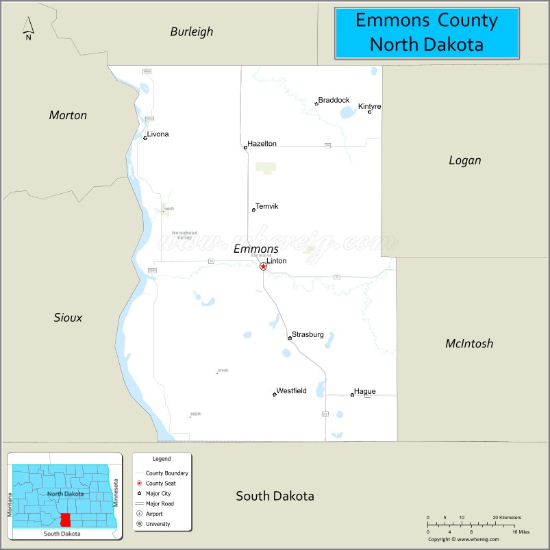
About Emmons County Map, North Dakota: The map showing the county boundary, county seat, major cities, highways, water bodies and neighbouring counties.
More North Dakota Maps & Info
About Emmons County, North Dakota
Emmons County is a county located in the U.S. state of North Dakota. It's county seat is Linton. As per 2020 census, the population of Emmons County is 3271 people and population density is square miles. According to the United States Census Bureau, the county has a total area of 1,510 sq mi (3,911 km2). Emmons County was established on 1879.
Emmons County Facts
| Continent | North America |
| Country | United States |
| State | North Dakota |
| County Seat | Linton |
| Largest City/Town | Linton |
| Established | 1879 (organized 1883) |
| Total Area | 1,555.3 sq mi (4,028.1 sq km) |
| Land Area | 1,510.8 sq mi (3,913.0 sq km) |
| Water Area | 44.5 sq mi (115.2 sq km) |
| Population | 3,242 (Census 2020) |
| Population Density | 2.1 people per sq mi |
| Time Zone | Central Time Zone |
| Major Highways | US Highway 83, North Dakota Highway 13, North Dakota Highway 1804, North Dakota Highway 11 |
| Major Rivers | Missouri River |
| Neighboring Counties | Burleigh, Kidder, Logan, McIntosh, Campbell County (SD), Walworth County (SD) |
| Famous For | Lake Oahe, Missouri River recreation, German-Russian heritage, agriculture, and hunting |
| Top Attractions | Lake Oahe, Beaver Lake State Park, Linton Zoo, Lawrence Welk Birthplace, Hazelton Recreation Area |
| Official Website | Official Website |
About Emmons County, North Dakota
Emmons County is located in south-central North Dakota along the Missouri River and was established in 1879. The county seat and largest city is Linton. The county is known for its agricultural economy, German-Russian cultural heritage, and extensive shoreline along Lake Oahe. Outdoor recreation, fishing, hunting, and farming are important parts of life throughout the county.
Cities and Towns in Emmons County, North Dakota
| City/Town | Population (Census 2020) | Latitude & Longitude |
|---|---|---|
| Linton (county seat) | 1,086 | 46.2666°N, 100.2326°W |
| Hazelton | 235 | 46.4847°N, 100.2793°W |
| Strasburg | 379 | 46.1348°N, 100.1573°W |
| Braddock | 21 | 46.5639°N, 100.0901°W |
| Kintyre | 41 | 46.5389°N, 99.9470°W |
| Temvik | 65 | 46.1372°N, 100.0945°W |
| Westfield | 13 | 46.0356°N, 100.2548°W |
| Lark | 9 | 46.4353°N, 100.5126°W |
| Winona (CDP) | 18 | 46.5734°N, 100.4370°W |
Best Golf Courses in Emmons County, North Dakota
| Golf Course | Location | Latitude & Longitude |
|---|---|---|
| Linton Country Club | Linton | 46.2704°N, 100.2407°W |
| Strasburg Golf Course | Strasburg | 46.1369°N, 100.1638°W |
What are Major Roads and Highways in Emmons County
Major highways connect the county to nearby regions and cities.
- US Highway 83 - major north-south route connecting Linton with Bismarck and South Dakota
- North Dakota Highway 13 - east-west route linking communities across southern North Dakota
- North Dakota Highway 1804 - scenic highway following the Missouri River and Lake Oahe shoreline
- North Dakota Highway 11 - serves northern portions of the county and agricultural areas
- County roads provide access to recreation areas, farms, ranches, and lakeside communities
Neighboring Counties of Emmons County
- Burleigh County (north)
- Kidder County (east)
- Logan County (southeast)
- McIntosh County (south)
- Campbell County, South Dakota (southwest)
- Walworth County, South Dakota (west)
What are Top Attractions in Emmons County, North Dakota
The county offers a mix of natural and cultural attractions.
| Main Sight Name | City | Famous For |
|---|---|---|
| Lake Oahe | Western County | Fishing, boating, camping, and water recreation |
| Beaver Lake State Park | Near Linton | Camping, hiking, and outdoor recreation |
| Lawrence Welk Birthplace | Strasburg | Historic home of the famous bandleader and television personality |
| Linton Zoo | Linton | Small community zoo and family attraction |
| Hazelton Recreation Area | Hazelton | Access to Missouri River recreation opportunities |
| Missouri River Scenic Areas | Countywide | Views, wildlife, and outdoor recreation |
| Strasburg Heritage Museum | Strasburg | German-Russian cultural exhibits |
| Linton Country Club | Linton | Golf and community events |
| McLean Bottoms Recreation Area | Lake Oahe Area | Camping and fishing access |
| Emmons County Historical Museum | Linton | County history and pioneer collections |
| Braddock Windbreak Area | Braddock | Prairie scenery and wildlife viewing |
| German-Russian Heritage Communities | Countywide | Cultural history and architecture |
Distance from Emmons County to Nearby Cities
The following distances are measured by road (driving).
- Linton to Hazelton (Emmons County), North Dakota - 15 mi (24 km)
- Linton to Strasburg (Emmons County), North Dakota - 10 mi (16 km)
- Linton to Bismarck (Burleigh County), North Dakota - 57 mi (92 km)
- Linton to Steele (Kidder County), North Dakota - 49 mi (79 km)
- Linton to Napoleon (Logan County), North Dakota - 27 mi (43 km)
- Linton to Ashley (McIntosh County), North Dakota - 44 mi (71 km)
- Linton to Wishek (McIntosh County), North Dakota - 53 mi (85 km)
- Linton to Mobridge (Walworth County), South Dakota - 61 mi (98 km)
- Linton to Herreid (Campbell County), South Dakota - 58 mi (93 km)
- Linton to Jamestown (Stutsman County), North Dakota - 96 mi (154 km)
- Linton to Dickinson (Stark County), North Dakota - 142 mi (229 km)
- Linton to Fargo (Cass County), North Dakota - 158 mi (254 km)
- Linton to Minot (Ward County), North Dakota - 169 mi (272 km)
- Linton to Grand Forks (Grand Forks County), North Dakota - 223 mi (359 km)
- Linton to Pierre (Hughes County), South Dakota - 173 mi (278 km)
References
- QuickFacts - U.S. Census Bureau
- United States Census Bureau
- United States Geological Survey (USGS)
- National Geodetic Survey
- Official County Website
- Adams County Map
- Barnes County Map
- Benson County Map
- Billings County Map
- Bottineau County Map
- Bowman County Map
- Burke County Map
- Burleigh County Map
- Cass County Map
- Cavalier County Map
- Dickey County Map
- Divide County Map
- Dunn County Map
- Eddy County Map
- Emmons County Map
- Foster County Map
- Golden Valley County Map
- Grand Forks County Map
- Grant County Map
- Griggs County Map
- Hettinger County Map
- Kidder County Map
- LaMoure County Map
- Logan County Map
- McHenry County Map
- McKenzie County Map
- McLean County Map
- McIntosh County Map
- Mercer County Map
- Morton County Map
- Mountrail County Map
- Nelson County Map
- Oliver County Map
- Pembina County Map
- Pierce County Map
- Ramsey County Map
- Ransom County Map
- Renville County Map
- Richland County Map
- Rolette County Map
- Sargent County Map
- Sheridan County Map
- Sioux County Map
- Slope County Map
- Stark County Map
- Steele County Map
- Stutsman County Map
- Towner County Map
- Traill County Map
- Walsh County Map
- Ward County Map
- Wells County Map
- Williams County Map
- Alabama Counties
- Alaska boroughs
- Arizona Counties
- Arkansas Counties
- California County Map
- Colorado Counties
- Connecticut Counties
- Delaware Counties
- Florida County Map
- Georgia County Map
- Hawaii Counties
- Idaho Counties
- Illinois Counties
- Indiana Counties
- Iowa Counties
- Kansas Counties
- Kentucky Counties
- Louisiana Counties
- Maine Counties
- Maryland Counties
- Massachusetts Counties
- Michigan County Map
- Minnesota Counties
- Mississippi Counties
- Missouri Counties
- Montana Counties
- Nebraska Counties
- Nevada Counties
- New York Counties
- New Hampshire Counties
- New Jersey Counties
- New Mexico Counties
- North Carolina Counties
- North Dakota Counties
- Ohio County Map
- Oklahoma Counties
- Oregon Counties
- Pennsylvania Counties
- Rhode Island Counties
- South Carolina Counties
- South Dakota Counties
- Map of Tennessee
- Texas County Map
- Utah Counties
- Vermont Counties
- Virginia Counties
- Washington Counties
- West Virginia Counties
- Wisconsin Counties
- Wyoming Counties