Written and Fact-checked by Whereig Editors | Updated On: May 31, 2026
Map of Mountrail County - Mountrail County is a county located in the U.S. state of North Dakota. Mountrail County Map showing cities, highways, important places and water bodies. Get Where is Mountrail County located in the map, major cities in Mountrail county, population, areas, and places of interest.
Map of Mountrail County, North Dakota
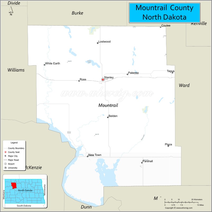
About Mountrail County Map, North Dakota: The map showing the county boundary, county seat, major cities, highways, water bodies and neighbouring counties.
More North Dakota Maps & Info
About Mountrail County, North Dakota
Mountrail County is a county located in the U.S. state of North Dakota. It's county seat is Stanley. As per 2020 census, the population of Mountrail County is 9576 people and population density is square miles. According to the United States Census Bureau, the county has a total area of 1,824 sq mi (4,724 km2). Mountrail County was established on 1873.
Mountrail County Facts
| Continent | North America |
| Country | United States |
| State | North Dakota |
| County Seat | Stanley |
| Largest City/Town | New Town |
| Established | 1873 (organized 1909) |
| Total Area | 1,941.0 sq mi (5,027.2 sq km) |
| Land Area | 1,825.0 sq mi (4,726.7 sq km) |
| Water Area | 116.0 sq mi (300.4 sq km) |
| Population | 9,809 (Census 2020) |
| Population Density | 5.4 people per sq mi |
| Time Zone | Central Time Zone |
| Major Highways | US Highway 2, US Highway 83, North Dakota Highway 23, North Dakota Highway 8, North Dakota Highway 1804 |
| Major Rivers | Missouri River, White Earth River |
| Neighboring Counties | Burke, Ward, McLean, Dunn, McKenzie, Williams |
| Famous For | Lake Sakakawea, Fort Berthold Reservation, Bakken oil production, fishing, and outdoor recreation |
| Top Attractions | Lake Sakakawea, Four Bears Bridge, Crow Flies High State Recreation Area, Earth Lodge Village, Fort Berthold Reservation |
| Official Website | Official Website |
About Mountrail County, North Dakota
Mountrail County is located in northwestern North Dakota and was established in 1873. The county seat is Stanley, while New Town is the largest city. The county borders Lake Sakakawea and includes a large portion of the Fort Berthold Indian Reservation. Agriculture, energy production, tourism, and outdoor recreation are major contributors to the local economy.
Cities and Towns in Mountrail County, North Dakota
| City/Town | Population (Census 2020) | Latitude & Longitude |
|---|---|---|
| Stanley (county seat) | 2,257 | 48.3175°N, 102.3902°W |
| New Town | 2,631 | 47.9808°N, 102.4902°W |
| Parshall | 903 | 47.9525°N, 102.1340°W |
| Ross | 97 | 48.3133°N, 102.5565°W |
| Plaza | 167 | 48.0358°N, 101.9602°W |
| Makoti | 125 | 47.9733°N, 102.0516°W |
| White Earth | 80 | 48.2836°N, 102.7745°W |
| Tagus | 12 | 48.3920°N, 102.3078°W |
| Lostwood (CDP) | 43 | 48.5731°N, 102.7914°W |
| Sanish (CDP) | 22 | 47.9946°N, 102.3321°W |
Best Golf Courses in Mountrail County, North Dakota
| Golf Course | Location | Latitude & Longitude |
|---|---|---|
| Links of North Dakota | Ray/Stanley Area | 48.3441°N, 102.4719°W |
| New Town Golf Club | New Town | 47.9818°N, 102.5032°W |
| Parshall Golf Course | Parshall | 47.9548°N, 102.1417°W |
What are Major Roads and Highways in Mountrail County
Major highways connect the county to nearby regions and cities.
- US Highway 2 - major east-west corridor connecting Stanley with Minot, Williston, and eastern North Dakota
- US Highway 83 - north-south route serving eastern portions of the county
- North Dakota Highway 23 - connects New Town with Watford City and Williston
- North Dakota Highway 8 - serves central and southern communities throughout the county
- North Dakota Highway 1804 - scenic route along Lake Sakakawea and the Missouri River corridor
Neighboring Counties of Mountrail County
- Burke County (north)
- Ward County (east)
- McLean County (southeast)
- Dunn County (south)
- McKenzie County (southwest)
- Williams County (west)
What are Top Attractions in Mountrail County, North Dakota
The county offers a mix of natural and cultural attractions.
| Main Sight Name | City | Famous For |
|---|---|---|
| Lake Sakakawea | New Town Area | Fishing, boating, camping, and water recreation |
| Crow Flies High State Recreation Area | Near New Town | Scenic overlook above Lake Sakakawea |
| Four Bears Bridge | New Town | Iconic bridge crossing Lake Sakakawea |
| Earth Lodge Village | New Town | Mandan, Hidatsa, and Arikara cultural heritage site |
| Fort Berthold Reservation | Countywide | Native American history and culture |
| Van Hook Arm Recreation Area | New Town | Fishing and boating destination |
| New Town Marina | New Town | Access to Lake Sakakawea recreation |
| Parshall Historical Museum | Parshall | Local history and pioneer exhibits |
| White Earth Valley | White Earth | Scenic prairie landscapes and wildlife viewing |
| Links of North Dakota | Stanley Area | Nationally recognized golf destination |
| Sanish Bay Recreation Area | Sanish | Camping and water activities |
| Missouri River Scenic Areas | Countywide | Photography and outdoor recreation |
Distance from Mountrail County to Nearby Cities
The following distances are measured by road (driving).
- Stanley to New Town (Mountrail County), North Dakota - 39 mi (63 km)
- Stanley to Parshall (Mountrail County), North Dakota - 30 mi (48 km)
- Stanley to Plaza (Mountrail County), North Dakota - 36 mi (58 km)
- Stanley to Williston (Williams County), North Dakota - 54 mi (87 km)
- Stanley to Watford City (McKenzie County), North Dakota - 72 mi (116 km)
- Stanley to Minot (Ward County), North Dakota - 54 mi (87 km)
- Stanley to New Town (Mountrail County), North Dakota - 39 mi (63 km)
- Stanley to Washburn (McLean County), North Dakota - 95 mi (153 km)
- Stanley to Mohall (Renville County), North Dakota - 62 mi (100 km)
- Stanley to Bowbells (Burke County), North Dakota - 53 mi (85 km)
- Stanley to Dickinson (Stark County), North Dakota - 123 mi (198 km)
- Stanley to Bismarck (Burleigh County), North Dakota - 125 mi (201 km)
- Stanley to Devils Lake (Ramsey County), North Dakota - 156 mi (251 km)
- Stanley to Grand Forks (Grand Forks County), North Dakota - 240 mi (386 km)
- Stanley to Fargo (Cass County), North Dakota - 267 mi (430 km)
References
- QuickFacts - U.S. Census Bureau
- United States Census Bureau
- United States Geological Survey (USGS)
- National Geodetic Survey
- Official County Website
- Adams County Map
- Barnes County Map
- Benson County Map
- Billings County Map
- Bottineau County Map
- Bowman County Map
- Burke County Map
- Burleigh County Map
- Cass County Map
- Cavalier County Map
- Dickey County Map
- Divide County Map
- Dunn County Map
- Eddy County Map
- Emmons County Map
- Foster County Map
- Golden Valley County Map
- Grand Forks County Map
- Grant County Map
- Griggs County Map
- Hettinger County Map
- Kidder County Map
- LaMoure County Map
- Logan County Map
- McHenry County Map
- McKenzie County Map
- McLean County Map
- McIntosh County Map
- Mercer County Map
- Morton County Map
- Mountrail County Map
- Nelson County Map
- Oliver County Map
- Pembina County Map
- Pierce County Map
- Ramsey County Map
- Ransom County Map
- Renville County Map
- Richland County Map
- Rolette County Map
- Sargent County Map
- Sheridan County Map
- Sioux County Map
- Slope County Map
- Stark County Map
- Steele County Map
- Stutsman County Map
- Towner County Map
- Traill County Map
- Walsh County Map
- Ward County Map
- Wells County Map
- Williams County Map
- Alabama Counties
- Alaska boroughs
- Arizona Counties
- Arkansas Counties
- California County Map
- Colorado Counties
- Connecticut Counties
- Delaware Counties
- Florida County Map
- Georgia County Map
- Hawaii Counties
- Idaho Counties
- Illinois Counties
- Indiana Counties
- Iowa Counties
- Kansas Counties
- Kentucky Counties
- Louisiana Counties
- Maine Counties
- Maryland Counties
- Massachusetts Counties
- Michigan County Map
- Minnesota Counties
- Mississippi Counties
- Missouri Counties
- Montana Counties
- Nebraska Counties
- Nevada Counties
- New York Counties
- New Hampshire Counties
- New Jersey Counties
- New Mexico Counties
- North Carolina Counties
- North Dakota Counties
- Ohio County Map
- Oklahoma Counties
- Oregon Counties
- Pennsylvania Counties
- Rhode Island Counties
- South Carolina Counties
- South Dakota Counties
- Map of Tennessee
- Texas County Map
- Utah Counties
- Vermont Counties
- Virginia Counties
- Washington Counties
- West Virginia Counties
- Wisconsin Counties
- Wyoming Counties