Written and Fact-checked by Whereig Editors | Updated On: May 31, 2026
Map of McIntosh County - McIntosh County is a county located in the U.S. state of North Dakota. McIntosh County Map showing cities, highways, important places and water bodies. Get Where is McIntosh County located in the map, major cities in McIntosh county, population, areas, and places of interest.
Map of McIntosh County, North Dakota
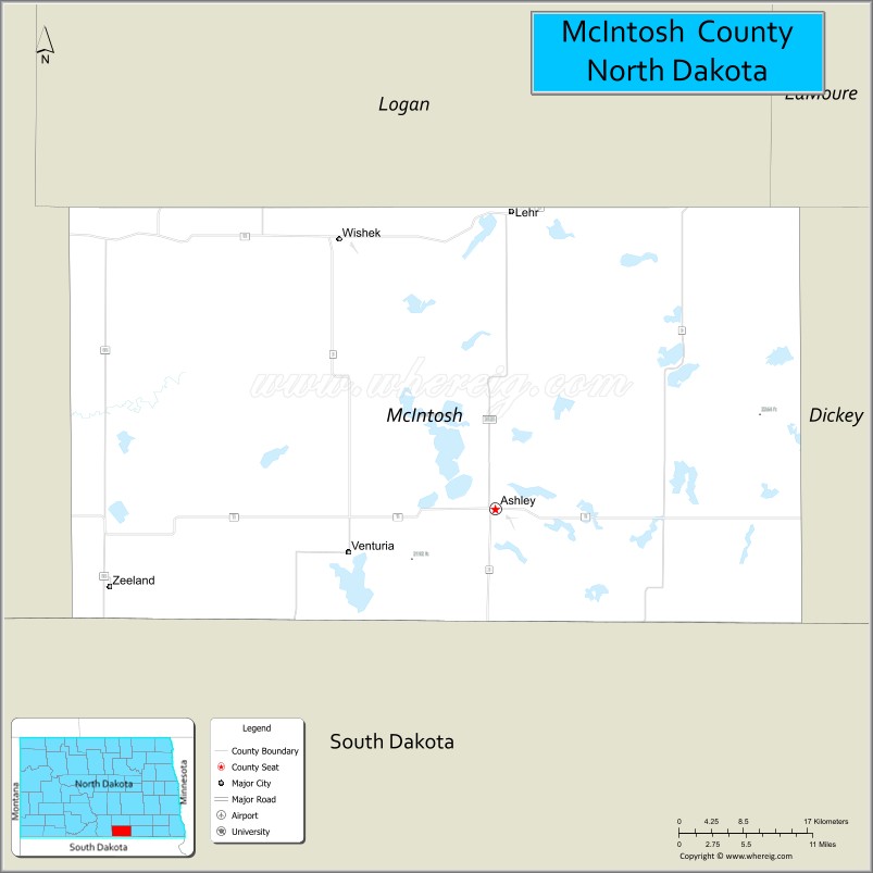
About McIntosh County Map, North Dakota: The map showing the county boundary, county seat, major cities, highways, water bodies and neighbouring counties.
More North Dakota Maps & Info
About McIntosh County, North Dakota
McIntosh County is a county located in the U.S. state of North Dakota. It's county seat is Ashley. As per 2020 census, the population of McIntosh County is 2513 people and population density is square miles. According to the United States Census Bureau, the county has a total area of 975 sq mi (2,525 km2). McIntosh County was established on 1883.
McIntosh County Facts
| Continent | North America |
| Country | United States |
| State | North Dakota |
| County Seat | Ashley |
| Largest City/Town | Wishek |
| Established | 1883 (organized 1884) |
| Total Area | 994.6 sq mi (2,575.0 sq km) |
| Land Area | 974.6 sq mi (2,524.2 sq km) |
| Water Area | 20.0 sq mi (51.8 sq km) |
| Population | 2,530 (Census 2020) |
| Population Density | 2.6 people per sq mi |
| Time Zone | Central Time Zone |
| Major Highways | North Dakota Highway 3, North Dakota Highway 11, North Dakota Highway 13 |
| Major Rivers | Beaver Creek, Spring Creek |
| Neighboring Counties | Logan, LaMoure, Dickey, Emmons, McPherson County (South Dakota), Campbell County (South Dakota) |
| Famous For | German-Russian heritage, agriculture, prairie lakes, hunting, and rural North Dakota culture |
| Top Attractions | Doyle Memorial State Recreation Area, Ashley Museum, Wishek Dam, Camp Lake, McIntosh County Heritage Sites |
| Official Website | Official Website |
About McIntosh County, North Dakota
McIntosh County is located in south-central North Dakota along the South Dakota border and was established in 1883. The county seat is Ashley, while Wishek is the largest city. The county is known for its strong German-Russian heritage, productive farmland, rolling prairie, and numerous lakes and wetlands. Agriculture remains the foundation of the local economy, supported by livestock production, grain farming, hunting, and outdoor recreation.
Cities and Towns in McIntosh County, North Dakota
| City/Town | Population (Census 2020) | Latitude & Longitude |
|---|---|---|
| Ashley (county seat) | 613 | 46.0347°N, 99.3748°W |
| Wishek | 889 | 46.2572°N, 99.5576°W |
| Venturia | 13 | 45.9439°N, 99.4765°W |
| Zeeland | 82 | 46.0138°N, 99.8248°W |
| Lehr (partly in Logan County) | 14 | 46.2963°N, 99.3521°W |
| Roloff Township | 12 | 46.0760°N, 99.5050°W |
Best Golf Courses in McIntosh County, North Dakota
| Golf Course | Location | Latitude & Longitude |
|---|---|---|
| Wishek Golf Course | Wishek | 46.2578°N, 99.5665°W |
| Ashley Country Club Golf Course | Ashley | 46.0415°N, 99.3829°W |
What are Major Roads and Highways in McIntosh County
Major highways connect the county to nearby regions and cities.
- North Dakota Highway 3 - north-south route connecting Ashley, Napoleon, and Bismarck-area communities
- North Dakota Highway 11 - east-west highway linking Ashley, Ellendale, and communities near the South Dakota border
- North Dakota Highway 13 - crosses northern portions of the county and connects Wishek with LaMoure and Emmons counties
- County roads provide access to farms, lakes, wildlife areas, and rural communities
Neighboring Counties of McIntosh County
- Logan County (north)
- LaMoure County (northeast)
- Dickey County (east)
- McPherson County, South Dakota (south)
- Campbell County, South Dakota (southwest)
- Emmons County (west)
What are Top Attractions in McIntosh County, North Dakota
The county offers a mix of natural and cultural attractions.
| Main Sight Name | City | Famous For |
|---|---|---|
| Doyle Memorial State Recreation Area | Near Wishek | Camping, fishing, boating, and outdoor recreation |
| Wishek Dam | Wishek | Fishing, wildlife viewing, and scenic prairie landscapes |
| Ashley Museum | Ashley | County history, pioneer exhibits, and local heritage |
| Camp Lake | Countywide | Fishing, birdwatching, and recreation |
| Green Lake Wildlife Area | Near Ashley | Waterfowl habitat and hunting opportunities |
| Coldwater Lake | Countywide | Fishing and nature observation |
| McIntosh County State Wildlife Management Area | Countywide | Wildlife conservation and hunting |
| Wishek Heritage Center | Wishek | German-Russian cultural history |
| Prairie Pothole Region | Countywide | Birdwatching and photography |
| Ashley City Park | Ashley | Community recreation and events |
Distance from McIntosh County to Nearby Cities
The following distances are measured by road (driving).
- Ashley to Wishek (McIntosh County), North Dakota - 18 mi (29 km)
- Ashley to Zeeland (McIntosh County), North Dakota - 26 mi (42 km)
- Ashley to Lehr (McIntosh County/Logan County), North Dakota - 21 mi (34 km)
- Ashley to Napoleon (Logan County), North Dakota - 43 mi (69 km)
- Ashley to LaMoure (LaMoure County), North Dakota - 53 mi (85 km)
- Ashley to Ellendale (Dickey County), North Dakota - 44 mi (71 km)
- Ashley to Linton (Emmons County), North Dakota - 53 mi (85 km)
- Ashley to Jamestown (Stutsman County), North Dakota - 88 mi (142 km)
- Ashley to Bismarck (Burleigh County), North Dakota - 95 mi (153 km)
- Ashley to Wahpeton (Richland County), North Dakota - 103 mi (166 km)
- Ashley to Fargo (Cass County), North Dakota - 129 mi (208 km)
- Ashley to Aberdeen (Brown County), South Dakota - 95 mi (153 km)
- Ashley to Pierre (Hughes County), South Dakota - 144 mi (232 km)
- Ashley to Grand Forks (Grand Forks County), North Dakota - 206 mi (332 km)
- Ashley to Minot (Ward County), North Dakota - 183 mi (295 km)
References
- QuickFacts - McIntosh County, North Dakota
- United States Census Bureau
- United States Geological Survey (USGS)
- National Geodetic Survey
- Official County Website
- Adams County Map
- Barnes County Map
- Benson County Map
- Billings County Map
- Bottineau County Map
- Bowman County Map
- Burke County Map
- Burleigh County Map
- Cass County Map
- Cavalier County Map
- Dickey County Map
- Divide County Map
- Dunn County Map
- Eddy County Map
- Emmons County Map
- Foster County Map
- Golden Valley County Map
- Grand Forks County Map
- Grant County Map
- Griggs County Map
- Hettinger County Map
- Kidder County Map
- LaMoure County Map
- Logan County Map
- McHenry County Map
- McKenzie County Map
- McLean County Map
- McIntosh County Map
- Mercer County Map
- Morton County Map
- Mountrail County Map
- Nelson County Map
- Oliver County Map
- Pembina County Map
- Pierce County Map
- Ramsey County Map
- Ransom County Map
- Renville County Map
- Richland County Map
- Rolette County Map
- Sargent County Map
- Sheridan County Map
- Sioux County Map
- Slope County Map
- Stark County Map
- Steele County Map
- Stutsman County Map
- Towner County Map
- Traill County Map
- Walsh County Map
- Ward County Map
- Wells County Map
- Williams County Map
- Alabama Counties
- Alaska boroughs
- Arizona Counties
- Arkansas Counties
- California County Map
- Colorado Counties
- Connecticut Counties
- Delaware Counties
- Florida County Map
- Georgia County Map
- Hawaii Counties
- Idaho Counties
- Illinois Counties
- Indiana Counties
- Iowa Counties
- Kansas Counties
- Kentucky Counties
- Louisiana Counties
- Maine Counties
- Maryland Counties
- Massachusetts Counties
- Michigan County Map
- Minnesota Counties
- Mississippi Counties
- Missouri Counties
- Montana Counties
- Nebraska Counties
- Nevada Counties
- New York Counties
- New Hampshire Counties
- New Jersey Counties
- New Mexico Counties
- North Carolina Counties
- North Dakota Counties
- Ohio County Map
- Oklahoma Counties
- Oregon Counties
- Pennsylvania Counties
- Rhode Island Counties
- South Carolina Counties
- South Dakota Counties
- Map of Tennessee
- Texas County Map
- Utah Counties
- Vermont Counties
- Virginia Counties
- Washington Counties
- West Virginia Counties
- Wisconsin Counties
- Wyoming Counties