Written and Fact-checked by Whereig Editors | Updated On: May 31, 2026
Map of Stark County - Stark County is a county located in the U.S. state of North Dakota. Stark County Map showing cities, highways, important places and water bodies. Get Where is Stark County located in the map, major cities in Stark county, population, areas, and places of interest.
Map of Stark County, North Dakota
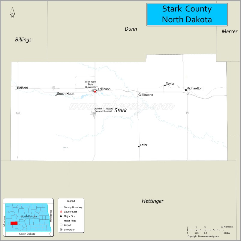
About Stark County Map, North Dakota: The map showing the county boundary, county seat, major cities, highways, water bodies and neighbouring counties.
More North Dakota Maps & Info
About Stark County, North Dakota
Stark County is a county located in the U.S. state of North Dakota. It's county seat is Dickinson. As per 2020 census, the population of Stark County is 33046 people and population density is square miles. According to the United States Census Bureau, the county has a total area of 1,338 sq mi (3,465 km2). Stark County was established on 1879.
Stark County Facts
| Continent | North America |
| Country | United States |
| State | North Dakota |
| County Seat | Dickinson |
| Largest City/Town | Dickinson |
| Established | 1879 |
| Total Area | 1,340.0 sq mi (3,470.6 sq km) |
| Land Area | 1,335.0 sq mi (3,457.7 sq km) |
| Water Area | 5.0 sq mi (13.0 sq km) |
| Population | 33,646 (Census 2020) |
| Population Density | 25.2 people per sq mi |
| Time Zone | Mountain Time Zone |
| Major Highways | Interstate 94, US Highway 10, US Highway 85, North Dakota Highway 22 |
| Major Rivers | Heart River, Green River |
| Neighboring Counties | Billings County, Dunn County, Mercer County, Oliver County, Hettinger County, Slope County |
| Famous For | Dickinson, Theodore Roosevelt history, oil industry, Dickinson State University, and Badlands landscapes |
| Top Attractions | Dakota Dinosaur Museum, Patterson Lake Recreation Area, Dickinson Museum Center, Ukrainian Cultural Institute, Heart River Golf Course |
| Official Website | Official Website |
About Stark County, North Dakota
Stark County is located in southwestern North Dakota and was established in 1879. The county seat and largest city is Dickinson. The county serves as an economic hub for western North Dakota and is known for agriculture, energy production, higher education, and access to the nearby Badlands region. Its location along Interstate 94 has helped make Dickinson a major commercial and transportation center.
Cities and Towns in Stark County, North Dakota
| City/Town | Population (Census 2020) | Latitude & Longitude |
|---|---|---|
| Dickinson (county seat) | 25,679 | 46.8792°N, 102.7896°W |
| Belfield | 996 | 46.8858°N, 103.1993°W |
| Gladstone | 284 | 46.8569°N, 102.5737°W |
| South Heart | 394 | 46.8636°N, 102.9927°W |
| Taylor | 188 | 46.9208°N, 102.4275°W |
| Richardton | 543 | 46.8836°N, 102.3151°W |
| Dodge | 121 | 47.2942°N, 102.2215°W |
| New Hradec (CDP) | 52 | 46.9882°N, 102.8406°W |
Best Golf Courses in Stark County, North Dakota
| Golf Course | Location | Latitude & Longitude |
|---|---|---|
| Heart River Golf Course | Dickinson | 46.9130°N, 102.7915°W |
| Bully Pulpit Golf Course | Medora Area | 46.9147°N, 103.5356°W |
| Par 3 Family Golf Course | Dickinson | 46.8851°N, 102.8128°W |
What are Major Roads and Highways in Stark County
Major highways connect the county to nearby regions and cities.
- Interstate 94 - primary east-west interstate connecting Dickinson with Bismarck, Fargo, Medora, and Montana
- US Highway 10 - historic route serving communities across southern North Dakota
- US Highway 85 - major north-south corridor linking the county with Williston, Watford City, and South Dakota
- North Dakota Highway 22 - connects Dickinson with Killdeer and southern North Dakota communities
- County roads provide access to agricultural areas, oil fields, and recreation sites
Neighboring Counties of Stark County
- Dunn County (north)
- Mercer County (northeast)
- Oliver County (east)
- Hettinger County (south)
- Slope County (southwest)
- Billings County (west)
What are Top Attractions in Stark County, North Dakota
The county offers a mix of natural and cultural attractions.
| Main Sight Name | City | Famous For |
|---|---|---|
| Dakota Dinosaur Museum | Dickinson | Large collection of dinosaur fossils and exhibits |
| Dickinson Museum Center | Dickinson | Regional history, paleontology, and cultural exhibits |
| Patterson Lake Recreation Area | Dickinson | Boating, fishing, camping, and trails |
| Ukrainian Cultural Institute | Dickinson | Ukrainian heritage exhibits and cultural programs |
| Heart River Golf Course | Dickinson | Premier public golf course |
| Dickinson State University | Dickinson | Historic university campus and educational center |
| Prairie Outpost Park | Dickinson | Pioneer village and historic buildings |
| West River Community Center | Dickinson | Indoor recreation and family activities |
| Assumption Abbey | Richardton | Historic Benedictine monastery |
| St. Mary's Church | Richardton | Notable religious architecture and heritage |
| Heart River Valley | Countywide | Scenic landscapes and wildlife viewing |
| Theodore Roosevelt National Park South Unit | Near Belfield | Badlands scenery, wildlife, and hiking opportunities |
Distance from Stark County to Nearby Cities
The following distances are measured by road (driving).
- Dickinson to Belfield (Stark County), North Dakota - 16 mi (26 km)
- Dickinson to South Heart (Stark County), North Dakota - 8 mi (13 km)
- Dickinson to Richardton (Stark County), North Dakota - 23 mi (37 km)
- Dickinson to Taylor (Stark County), North Dakota - 24 mi (39 km)
- Dickinson to Killdeer (Dunn County), North Dakota - 52 mi (84 km)
- Dickinson to Medora (Billings County), North Dakota - 36 mi (58 km)
- Dickinson to Mott (Hettinger County), North Dakota - 53 mi (85 km)
- Dickinson to Beulah (Mercer County), North Dakota - 72 mi (116 km)
- Dickinson to Mandan (Morton County), North Dakota - 98 mi (158 km)
- Dickinson to Bismarck (Burleigh County), North Dakota - 103 mi (166 km)
- Dickinson to Watford City (McKenzie County), North Dakota - 92 mi (148 km)
- Dickinson to Williston (Williams County), North Dakota - 141 mi (227 km)
- Dickinson to Jamestown (Stutsman County), North Dakota - 199 mi (320 km)
- Dickinson to Fargo (Cass County), North Dakota - 291 mi (468 km)
- Dickinson to Rapid City (Pennington County), South Dakota - 221 mi (356 km)
References
- QuickFacts - Stark County, North Dakota
- United States Census Bureau
- United States Geological Survey (USGS)
- National Geodetic Survey
- Official County Website
- Adams County Map
- Barnes County Map
- Benson County Map
- Billings County Map
- Bottineau County Map
- Bowman County Map
- Burke County Map
- Burleigh County Map
- Cass County Map
- Cavalier County Map
- Dickey County Map
- Divide County Map
- Dunn County Map
- Eddy County Map
- Emmons County Map
- Foster County Map
- Golden Valley County Map
- Grand Forks County Map
- Grant County Map
- Griggs County Map
- Hettinger County Map
- Kidder County Map
- LaMoure County Map
- Logan County Map
- McHenry County Map
- McKenzie County Map
- McLean County Map
- McIntosh County Map
- Mercer County Map
- Morton County Map
- Mountrail County Map
- Nelson County Map
- Oliver County Map
- Pembina County Map
- Pierce County Map
- Ramsey County Map
- Ransom County Map
- Renville County Map
- Richland County Map
- Rolette County Map
- Sargent County Map
- Sheridan County Map
- Sioux County Map
- Slope County Map
- Stark County Map
- Steele County Map
- Stutsman County Map
- Towner County Map
- Traill County Map
- Walsh County Map
- Ward County Map
- Wells County Map
- Williams County Map
- Alabama Counties
- Alaska boroughs
- Arizona Counties
- Arkansas Counties
- California County Map
- Colorado Counties
- Connecticut Counties
- Delaware Counties
- Florida County Map
- Georgia County Map
- Hawaii Counties
- Idaho Counties
- Illinois Counties
- Indiana Counties
- Iowa Counties
- Kansas Counties
- Kentucky Counties
- Louisiana Counties
- Maine Counties
- Maryland Counties
- Massachusetts Counties
- Michigan County Map
- Minnesota Counties
- Mississippi Counties
- Missouri Counties
- Montana Counties
- Nebraska Counties
- Nevada Counties
- New York Counties
- New Hampshire Counties
- New Jersey Counties
- New Mexico Counties
- North Carolina Counties
- North Dakota Counties
- Ohio County Map
- Oklahoma Counties
- Oregon Counties
- Pennsylvania Counties
- Rhode Island Counties
- South Carolina Counties
- South Dakota Counties
- Map of Tennessee
- Texas County Map
- Utah Counties
- Vermont Counties
- Virginia Counties
- Washington Counties
- West Virginia Counties
- Wisconsin Counties
- Wyoming Counties