Written and Fact-checked by Whereig Editors | Updated On: May 31, 2026
Map of McKenzie County - McKenzie County is a county located in the U.S. state of North Dakota. McKenzie County Map showing cities, highways, important places and water bodies. Get Where is McKenzie County located in the map, major cities in McKenzie county, population, areas, and places of interest.
Map of McKenzie County, North Dakota
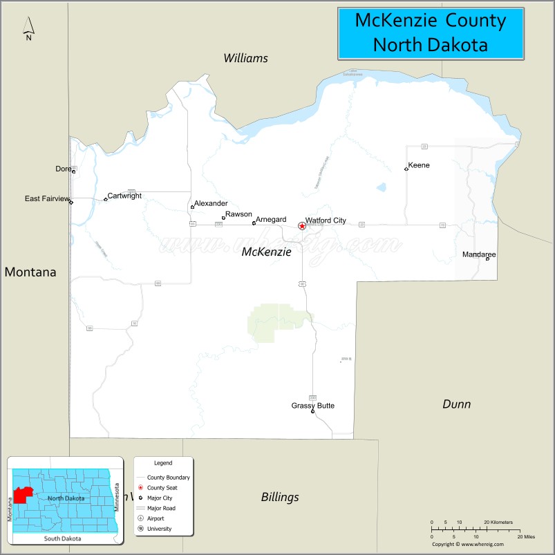
About McKenzie County Map, North Dakota: The map showing the county boundary, county seat, major cities, highways, water bodies and neighbouring counties.
More North Dakota Maps & Info
About McKenzie County, North Dakota
McKenzie County is a county located in the U.S. state of North Dakota. It's county seat is Watford City. As per 2020 census, the population of McKenzie County is 13819 people and population density is square miles. According to the United States Census Bureau, the county has a total area of 2,742 sq mi (7,102 km2). McKenzie County was established on 1905.
McKenzie County Facts
| Continent | North America |
| Country | United States |
| State | North Dakota |
| County Seat | Watford City |
| Largest City/Town | Watford City |
| Established | 1883 |
| Total Area | 2,861.5 sq mi (7,411.2 sq km) |
| Land Area | 2,760.0 sq mi (7,148.4 sq km) |
| Water Area | 101.5 sq mi (262.8 sq km) |
| Population | 14,704 (Census 2020) |
| Population Density | 5.3 people per sq mi |
| Time Zone | Mountain Time Zone |
| Major Highways | US Highway 85, North Dakota Highway 23, North Dakota Highway 68, North Dakota Highway 1806 |
| Major Rivers | Missouri River, Little Missouri River, Yellowstone River |
| Neighboring Counties | Williams, Mountrail, Dunn, Billings, Golden Valley, Richland County (Montana), Roosevelt County (Montana) |
| Famous For | Theodore Roosevelt National Park, Bakken oil production, Missouri River recreation, and North Dakota Badlands |
| Top Attractions | Theodore Roosevelt National Park North Unit, Long X Trading Post Visitor Center, Fort Union Trading Post National Historic Site, Lake Sakakawea, Little Missouri State Park |
| Official Website | Official Website |
About McKenzie County, North Dakota
McKenzie County is located in northwestern North Dakota and was established in 1883. The county seat and largest city is Watford City. It is the largest county in North Dakota by area and is known for its rugged badlands, river valleys, energy development, and outdoor recreation. The county plays a major role in the Bakken oil region while also preserving some of the state's most scenic natural landscapes.
Cities and Towns in McKenzie County, North Dakota
| City/Town | Population (Census 2020) | Latitude & Longitude |
|---|---|---|
| Watford City (county seat) | 6,207 | 47.8025°N, 103.2832°W |
| Alexander | 240 | 47.8505°N, 103.6427°W |
| Arnegard | 513 | 47.8036°N, 102.9318°W |
| Cartwright | 535 | 47.8566°N, 103.9358°W |
| East Fairview | 267 | 47.8597°N, 104.0463°W |
| Keene (CDP) | 45 | 47.9621°N, 102.9356°W |
| Grassy Butte (CDP) | 29 | 47.3947°N, 103.2537°W |
| Charlson (CDP) | 95 | 47.9021°N, 102.7814°W |
| Schafer (CDP) | 32 | 47.8803°N, 102.7702°W |
Best Golf Courses in McKenzie County, North Dakota
| Golf Course | Location | Latitude & Longitude |
|---|---|---|
| Watford City Golf Club | Watford City | 47.8079°N, 103.2872°W |
| Fox Hills Golf Course | Watford City | 47.7964°N, 103.2958°W |
What are Major Roads and Highways in McKenzie County
Major highways connect the county to nearby regions and cities.
- US Highway 85 - major north-south route connecting Watford City with Williston, Belfield, and South Dakota
- North Dakota Highway 23 - east-west highway linking Watford City with New Town, Williston, and Interstate 94
- North Dakota Highway 68 - provides access to rural communities and recreation areas
- North Dakota Highway 1806 - follows portions of the Missouri River and Lake Sakakawea shoreline
- County roads connect energy production areas, ranches, parks, and recreation destinations
Neighboring Counties of McKenzie County
- Williams County (north)
- Mountrail County (east)
- Dunn County (southeast)
- Billings County (south)
- Golden Valley County (southwest)
- Richland County, Montana (west)
- Roosevelt County, Montana (northwest)
What are Top Attractions in McKenzie County, North Dakota
The county offers a mix of natural and cultural attractions.
| Main Sight Name | City | Famous For |
|---|---|---|
| Theodore Roosevelt National Park - North Unit | Near Watford City | Badlands scenery, wildlife viewing, and hiking |
| Fort Union Trading Post National Historic Site | Near Williston Area | Historic fur trading post on the Missouri River |
| Long X Trading Post Visitor Center | Watford City | Regional history and visitor information |
| Little Missouri State Park | Near Grassy Butte | Horseback riding, camping, and rugged badlands |
| Lake Sakakawea | Eastern County | Boating, fishing, and water recreation |
| Missouri-Yellowstone Confluence Area | Near Cartwright | Historic river meeting point and scenic views |
| Cartwright Tunnel | Cartwright | Only railroad tunnel in North Dakota |
| Watford City Golf Club | Watford City | Golf and outdoor recreation |
| Badlands Overlooks | Countywide | Photography and scenic drives |
| Maah Daah Hey Trail Access Points | Southern County | Mountain biking, hiking, and horseback riding |
| Keene Dome Area | Keene | Geological significance within the Bakken region |
| Lake Sakakawea State Recreation Areas | Eastern County | Camping and fishing opportunities |
Distance from McKenzie County to Nearby Cities
The following distances are measured by road (driving).
- Watford City to Arnegard (McKenzie County), North Dakota - 22 mi (35 km)
- Watford City to Alexander (McKenzie County), North Dakota - 23 mi (37 km)
- Watford City to Cartwright (McKenzie County), North Dakota - 42 mi (68 km)
- Watford City to Williston (Williams County), North Dakota - 28 mi (45 km)
- Watford City to New Town (Mountrail County), North Dakota - 51 mi (82 km)
- Watford City to Killdeer (Dunn County), North Dakota - 55 mi (89 km)
- Watford City to Medora (Billings County), North Dakota - 68 mi (109 km)
- Watford City to Beach (Golden Valley County), North Dakota - 96 mi (154 km)
- Watford City to Sidney (Richland County), Montana - 52 mi (84 km)
- Watford City to Dickinson (Stark County), North Dakota - 87 mi (140 km)
- Watford City to Minot (Ward County), North Dakota - 127 mi (204 km)
- Watford City to Bismarck (Burleigh County), North Dakota - 188 mi (303 km)
- Watford City to Grand Forks (Grand Forks County), North Dakota - 333 mi (536 km)
- Watford City to Fargo (Cass County), North Dakota - 347 mi (558 km)
- Watford City to Billings (Yellowstone County), Montana - 279 mi (449 km)
References
- QuickFacts - McKenzie County, North Dakota
- United States Census Bureau
- United States Geological Survey (USGS)
- National Geodetic Survey
- Official County Website
- Adams County Map
- Barnes County Map
- Benson County Map
- Billings County Map
- Bottineau County Map
- Bowman County Map
- Burke County Map
- Burleigh County Map
- Cass County Map
- Cavalier County Map
- Dickey County Map
- Divide County Map
- Dunn County Map
- Eddy County Map
- Emmons County Map
- Foster County Map
- Golden Valley County Map
- Grand Forks County Map
- Grant County Map
- Griggs County Map
- Hettinger County Map
- Kidder County Map
- LaMoure County Map
- Logan County Map
- McHenry County Map
- McKenzie County Map
- McLean County Map
- McIntosh County Map
- Mercer County Map
- Morton County Map
- Mountrail County Map
- Nelson County Map
- Oliver County Map
- Pembina County Map
- Pierce County Map
- Ramsey County Map
- Ransom County Map
- Renville County Map
- Richland County Map
- Rolette County Map
- Sargent County Map
- Sheridan County Map
- Sioux County Map
- Slope County Map
- Stark County Map
- Steele County Map
- Stutsman County Map
- Towner County Map
- Traill County Map
- Walsh County Map
- Ward County Map
- Wells County Map
- Williams County Map
- Alabama Counties
- Alaska boroughs
- Arizona Counties
- Arkansas Counties
- California County Map
- Colorado Counties
- Connecticut Counties
- Delaware Counties
- Florida County Map
- Georgia County Map
- Hawaii Counties
- Idaho Counties
- Illinois Counties
- Indiana Counties
- Iowa Counties
- Kansas Counties
- Kentucky Counties
- Louisiana Counties
- Maine Counties
- Maryland Counties
- Massachusetts Counties
- Michigan County Map
- Minnesota Counties
- Mississippi Counties
- Missouri Counties
- Montana Counties
- Nebraska Counties
- Nevada Counties
- New York Counties
- New Hampshire Counties
- New Jersey Counties
- New Mexico Counties
- North Carolina Counties
- North Dakota Counties
- Ohio County Map
- Oklahoma Counties
- Oregon Counties
- Pennsylvania Counties
- Rhode Island Counties
- South Carolina Counties
- South Dakota Counties
- Map of Tennessee
- Texas County Map
- Utah Counties
- Vermont Counties
- Virginia Counties
- Washington Counties
- West Virginia Counties
- Wisconsin Counties
- Wyoming Counties