Written and Fact-checked by Whereig Editors | Updated On: May 31, 2026
Map of Billings County - Billings County is a county located in the U.S. state of North Dakota. Billings County Map showing cities, highways, important places and water bodies. Get Where is Billings County located in the map, major cities in Billings county, population, areas, and places of interest.
Map of Billings County, North Dakota
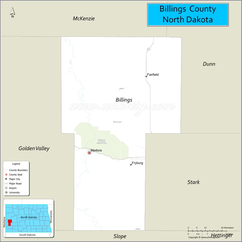
About Billings County Map, North Dakota: The map showing the county boundary, county seat, major cities, highways, water bodies and neighbouring counties.
More North Dakota Maps & Info
About Billings County, North Dakota
Billings County is a county located in the U.S. state of North Dakota. It's county seat is Medora. As per 2020 census, the population of Billings County is 955 people and population density is square miles. According to the United States Census Bureau, the county has a total area of 1,152 sq mi (2,984 km2). Billings County was established on 1879.
Billings County Facts
| Continent | North America |
| Country | United States |
| State | North Dakota |
| County Seat | Medora |
| Largest City/Town | Medora |
| Established | 1886 |
| Total Area | 1,151.1 sq mi (2,981.3 sq km) |
| Land Area | 1,148.4 sq mi (2,974.3 sq km) |
| Water Area | 2.7 sq mi (7.0 sq km) |
| Population | 945 (Census 2020) |
| Population Density | 0.8 people per sq mi |
| Time Zone | Mountain Time Zone |
| Major Highways | Interstate 94, US Highway 85, North Dakota Highway 16 |
| Major Rivers | Little Missouri River |
| Neighboring Counties | McKenzie, Golden Valley, Slope, Stark, Dunn |
| Famous For | Theodore Roosevelt National Park, Medora, North Dakota Badlands, scenic drives, and outdoor recreation |
| Top Attractions | Theodore Roosevelt National Park South Unit, Medora Musical, Chateau de Mores, Burning Coal Vein Trail, Painted Canyon |
| Official Website | Official Website |
About Billings County, North Dakota
Billings County is located in western North Dakota and was established in 1886. The county seat is Medora, which is also the largest community. The county is dominated by the rugged North Dakota Badlands and the Little Missouri River Valley. It is one of the state's leading tourism destinations due to Theodore Roosevelt National Park and its rich western heritage.
Cities and Towns in Billings County, North Dakota
| City/Town | Population (Census 2020) | Latitude & Longitude |
|---|---|---|
| Medora (county seat) | 121 | 46.9139°N, 103.5244°W |
| Belfield | 996 | 46.8853°N, 103.1991°W |
| South Heart | 394 | 46.8647°N, 103.0505°W |
| Fryburg (CDP) | 65 | 46.9564°N, 103.2779°W |
Best Golf Courses in Billings County, North Dakota
| Golf Course | Location | Latitude & Longitude |
|---|---|---|
| Bully Pulpit Golf Course | Medora | 46.9058°N, 103.5496°W |
What are Major Roads and Highways in Billings County
Major highways connect the county to nearby regions and cities.
- Interstate 94 - major east-west route connecting Medora with Dickinson, Bismarck, and Montana
- US Highway 85 - north-south corridor connecting western North Dakota oil-producing regions
- North Dakota Highway 16 - scenic route serving Medora and nearby Badlands areas
- East River Road and park roads - provide access to Theodore Roosevelt National Park and recreational sites
Neighboring Counties of Billings County
- McKenzie County (north)
- Dunn County (east)
- Stark County (southeast)
- Slope County (south)
- Golden Valley County (west)
What are Top Attractions in Billings County, North Dakota
The county offers a mix of natural and cultural attractions.
| Main Sight Name | City | Famous For |
|---|---|---|
| Theodore Roosevelt National Park - South Unit | Medora | Badlands scenery, wildlife, hiking, and scenic drives |
| Painted Canyon Visitor Center | Medora Area | Panoramic Badlands views and visitor information |
| Medora Musical | Medora | Famous outdoor western-themed musical performance |
| Chateau de Mores State Historic Site | Medora | Historic 1880s mansion of the Marquis de Mores |
| Bully Pulpit Golf Course | Medora | Nationally recognized golf course in the Badlands |
| Burning Coal Vein Trail | Medora | Popular hiking trail through colorful Badlands formations |
| Maltese Cross Cabin | Medora | Theodore Roosevelt's historic ranch cabin |
| North Dakota Cowboy Hall of Fame | Medora | Western history and ranching heritage exhibits |
| Little Missouri River | Countywide | Canoeing, fishing, and scenic landscapes |
| Theodore Roosevelt Presidential Library Site | Medora | Major cultural and educational development |
| Maah Daah Hey Trail Access | Medora | Long-distance hiking, biking, and horseback riding trail |
| Badlands Overlooks | Countywide | Dramatic geological formations and photography spots |
Distance from Billings County to Nearby Cities
The following distances are measured by road (driving).
- Medora to Belfield (Billings County), North Dakota - 16 mi (26 km)
- Medora to South Heart (Billings County), North Dakota - 29 mi (47 km)
- Medora to Dickinson (Stark County), North Dakota - 35 mi (56 km)
- Medora to Beach (Golden Valley County), North Dakota - 30 mi (48 km)
- Medora to Watford City (McKenzie County), North Dakota - 83 mi (134 km)
- Medora to Killdeer (Dunn County), North Dakota - 76 mi (122 km)
- Medora to Bowman (Bowman County), North Dakota - 84 mi (135 km)
- Medora to Bismarck (Burleigh County), North Dakota - 136 mi (219 km)
- Medora to Minot (Ward County), North Dakota - 173 mi (278 km)
- Medora to Williston (Williams County), North Dakota - 135 mi (217 km)
- Medora to Miles City (Custer County), Montana - 111 mi (179 km)
- Medora to Glendive (Dawson County), Montana - 50 mi (80 km)
- Medora to Fargo (Cass County), North Dakota - 307 mi (494 km)
- Medora to Rapid City (Pennington County), South Dakota - 218 mi (351 km)
- Medora to New England (Hettinger County), North Dakota - 61 mi (98 km)
References
- QuickFacts - U.S. Census Bureau
- United States Census Bureau
- United States Geological Survey (USGS)
- National Geodetic Survey
- Official County Website
- Adams County Map
- Barnes County Map
- Benson County Map
- Billings County Map
- Bottineau County Map
- Bowman County Map
- Burke County Map
- Burleigh County Map
- Cass County Map
- Cavalier County Map
- Dickey County Map
- Divide County Map
- Dunn County Map
- Eddy County Map
- Emmons County Map
- Foster County Map
- Golden Valley County Map
- Grand Forks County Map
- Grant County Map
- Griggs County Map
- Hettinger County Map
- Kidder County Map
- LaMoure County Map
- Logan County Map
- McHenry County Map
- McKenzie County Map
- McLean County Map
- McIntosh County Map
- Mercer County Map
- Morton County Map
- Mountrail County Map
- Nelson County Map
- Oliver County Map
- Pembina County Map
- Pierce County Map
- Ramsey County Map
- Ransom County Map
- Renville County Map
- Richland County Map
- Rolette County Map
- Sargent County Map
- Sheridan County Map
- Sioux County Map
- Slope County Map
- Stark County Map
- Steele County Map
- Stutsman County Map
- Towner County Map
- Traill County Map
- Walsh County Map
- Ward County Map
- Wells County Map
- Williams County Map
- Alabama Counties
- Alaska boroughs
- Arizona Counties
- Arkansas Counties
- California County Map
- Colorado Counties
- Connecticut Counties
- Delaware Counties
- Florida County Map
- Georgia County Map
- Hawaii Counties
- Idaho Counties
- Illinois Counties
- Indiana Counties
- Iowa Counties
- Kansas Counties
- Kentucky Counties
- Louisiana Counties
- Maine Counties
- Maryland Counties
- Massachusetts Counties
- Michigan County Map
- Minnesota Counties
- Mississippi Counties
- Missouri Counties
- Montana Counties
- Nebraska Counties
- Nevada Counties
- New York Counties
- New Hampshire Counties
- New Jersey Counties
- New Mexico Counties
- North Carolina Counties
- North Dakota Counties
- Ohio County Map
- Oklahoma Counties
- Oregon Counties
- Pennsylvania Counties
- Rhode Island Counties
- South Carolina Counties
- South Dakota Counties
- Map of Tennessee
- Texas County Map
- Utah Counties
- Vermont Counties
- Virginia Counties
- Washington Counties
- West Virginia Counties
- Wisconsin Counties
- Wyoming Counties