Written and Fact-checked by Whereig Editors | Updated On: May 31, 2026
Map of Grand Forks County - Grand Forks County is a county located in the U.S. state of North Dakota. Grand Forks County Map showing cities, highways, important places and water bodies. Get Where is Grand Forks County located in the map, major cities in Grand Forks county, population, areas, and places of interest.
Map of Grand Forks County, North Dakota
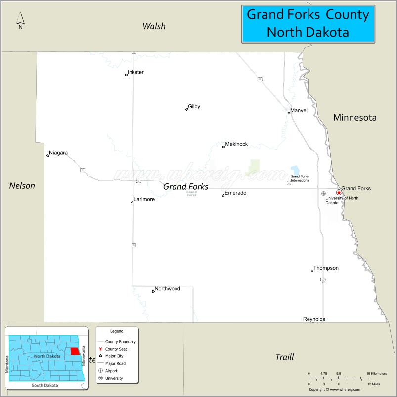
About Grand Forks County Map, North Dakota: The map showing the county boundary, county seat, major cities, highways, water bodies and neighbouring counties.
More North Dakota Maps & Info
About Grand Forks County, North Dakota
Grand Forks County is a county located in the U.S. state of North Dakota. It's county seat is Grand Forks. As per 2020 census, the population of Grand Forks County is 72705 people and population density is square miles. According to the United States Census Bureau, the county has a total area of 1,438 sq mi (3,724 km2). Grand Forks County was established on 1873.
Grand Forks County Facts
| Continent | North America |
| Country | United States |
| State | North Dakota |
| County Seat | Grand Forks |
| Largest City/Town | Grand Forks |
| Established | 1873 |
| Total Area | 1,440.3 sq mi (3,730.4 sq km) |
| Land Area | 1,436.0 sq mi (3,719.2 sq km) |
| Water Area | 4.3 sq mi (11.2 sq km) |
| Population | 73,170 (Census 2020) |
| Population Density | 50.9 people per sq mi |
| Time Zone | Central Time Zone |
| Major Highways | Interstate 29, US Highway 2, US Highway 81, North Dakota Highway 18, North Dakota Highway 33 |
| Major Rivers | Red River of the North, Red Lake River, Turtle River |
| Neighboring Counties | Walsh, Nelson, Griggs, Traill, Polk County (Minnesota) |
| Famous For | University of North Dakota, Grand Forks Air Force Base, Red River Valley agriculture, and higher education |
| Top Attractions | University of North Dakota, Ralph Engelstad Arena, North Dakota Museum of Art, Greenway, Grand Forks Air Force Base Heritage Sites |
| Official Website | Official Website |
About Grand Forks County, North Dakota
Grand Forks County is located in northeastern North Dakota along the Minnesota border and was established in 1873. The county seat and largest city is Grand Forks. Situated in the fertile Red River Valley, the county is a major center for higher education, healthcare, aerospace, technology, and agriculture. The county is home to the University of North Dakota and one of the state's largest metropolitan areas.
Cities and Towns in Grand Forks County, North Dakota
| City/Town | Population (Census 2020) | Latitude & Longitude |
|---|---|---|
| Grand Forks (county seat) | 59,166 | 47.9253°N, 97.0329°W |
| Larimore | 1,346 | 47.9061°N, 97.6265°W |
| Northwood | 982 | 47.7347°N, 97.5662°W |
| Thompson | 1,057 | 47.7730°N, 97.1090°W |
| Manvel | 255 | 48.0780°N, 97.1762°W |
| Emerado | 443 | 47.9230°N, 97.3595°W |
| Niagara | 47 | 47.9828°N, 97.8662°W |
| Arvilla | 29 | 48.0328°N, 97.4995°W |
| Gilby | 237 | 48.0800°N, 97.4118°W |
| Inkster | 45 | 48.1802°N, 97.6434°W |
| Mekinock | 72 | 47.9186°N, 97.3012°W |
| Reynolds | 301 | 47.6758°N, 97.1153°W |
| Buxton | 348 | 47.6028°N, 97.0979°W |
| Auburn | 19 | 48.0741°N, 97.5918°W |
| Fordville (partly) | 196 | 48.2164°N, 97.8004°W |
| Grand Forks Air Force Base (CDP) | 2,367 | 47.9605°N, 97.4014°W |
| Prairie Rose (CDP) | 73 | 47.9148°N, 97.0094°W |
Best Golf Courses in Grand Forks County, North Dakota
| Golf Course | Location | Latitude & Longitude |
|---|---|---|
| King's Walk Golf Course | Grand Forks | 47.9508°N, 97.0848°W |
| Lincoln Golf Course | Grand Forks | 47.9059°N, 97.0580°W |
| Ray Richards Golf Course | Grand Forks | 47.9167°N, 97.0945°W |
| Valley Golf Course | Grand Forks | 47.9365°N, 97.0275°W |
| Larimore Golf Club | Larimore | 47.9110°N, 97.6320°W |
What are Major Roads and Highways in Grand Forks County
Major highways connect the county to nearby regions and cities.
- Interstate 29 - major north-south interstate connecting Grand Forks with Fargo, Winnipeg, and Canada
- US Highway 2 - east-west route linking Grand Forks with Devils Lake, Minot, and Minnesota
- US Highway 81 - historic route serving eastern North Dakota communities
- North Dakota Highway 18 - connects western and northern county communities
- North Dakota Highway 33 - provides access to Larimore and surrounding agricultural areas
Neighboring Counties of Grand Forks County
- Walsh County (north)
- Nelson County (west)
- Griggs County (southwest)
- Traill County (south)
- Polk County, Minnesota (east)
What are Top Attractions in Grand Forks County, North Dakota
The county offers a mix of natural and cultural attractions.
| Main Sight Name | City | Famous For |
|---|---|---|
| University of North Dakota | Grand Forks | Flagship university and aerospace research programs |
| Ralph Engelstad Arena | Grand Forks | Home of UND hockey and major events |
| North Dakota Museum of Art | Grand Forks | Regional and international art collections |
| Greater Grand Forks Greenway | Grand Forks | Large urban park system along the Red River |
| Japanese Gardens | Grand Forks | Scenic garden honoring international friendship |
| Splashers of the South Seas | Grand Forks | Indoor water park attraction |
| Grand Forks Air Force Base Heritage Center | Grand Forks AFB | Military history exhibits |
| King's Walk Golf Course | Grand Forks | Championship golf course |
| Turtle River State Park | Near Arvilla | Camping, hiking, and river recreation |
| Empire Arts Center | Grand Forks | Historic theater and performing arts venue |
| Widman's Candy Shop | Grand Forks | Historic confectionery known for Chippers |
| Downtown Grand Forks Historic District | Grand Forks | Restaurants, shopping, and historic architecture |
Distance from Grand Forks County to Nearby Cities
The following distances are measured by road (driving).
- Grand Forks to East Grand Forks (Polk County), Minnesota - 3 mi (5 km)
- Grand Forks to Thompson (Grand Forks County), North Dakota - 11 mi (18 km)
- Grand Forks to Larimore (Grand Forks County), North Dakota - 31 mi (50 km)
- Grand Forks to Grafton (Walsh County), North Dakota - 42 mi (68 km)
- Grand Forks to Hillsboro (Traill County), North Dakota - 42 mi (68 km)
- Grand Forks to Devils Lake (Ramsey County), North Dakota - 88 mi (142 km)
- Grand Forks to Cooperstown (Griggs County), North Dakota - 86 mi (138 km)
- Grand Forks to Fargo (Cass County), North Dakota - 81 mi (130 km)
- Grand Forks to Wahpeton (Richland County), North Dakota - 108 mi (174 km)
- Grand Forks to Jamestown (Stutsman County), North Dakota - 121 mi (195 km)
- Grand Forks to Bismarck (Burleigh County), North Dakota - 223 mi (359 km)
- Grand Forks to Minot (Ward County), North Dakota - 218 mi (351 km)
- Grand Forks to Winnipeg, Manitoba - 145 mi (233 km)
- Grand Forks to Bemidji (Beltrami County), Minnesota - 109 mi (175 km)
- Grand Forks to Duluth (St. Louis County), Minnesota - 261 mi (420 km)