Written and Fact-checked by Whereig Editors | Updated On: May 31, 2026
Map of Slope County - Slope County is a county located in the U.S. state of North Dakota. Slope County Map showing cities, highways, important places and water bodies. Get Where is Slope County located in the map, major cities in Slope county, population, areas, and places of interest.
Map of Slope County, North Dakota
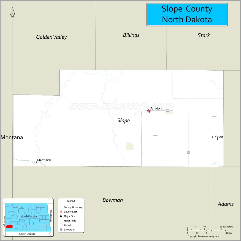
About Slope County Map, North Dakota: The map showing the county boundary, county seat, major cities, highways, water bodies and neighbouring counties.
More North Dakota Maps & Info
About Slope County, North Dakota
Slope County is a county located in the U.S. state of North Dakota. It's county seat is Amidon. As per 2020 census, the population of Slope County is 690 people and population density is square miles. According to the United States Census Bureau, the county has a total area of 1,218 sq mi (3,155 km2). Slope County was established on 1915.
Slope County Facts
| Continent | North America |
| Country | United States |
| State | North Dakota |
| County Seat | Amidon |
| Largest City/Town | Marmarth |
| Established | 1915 |
| Total Area | 1,219.0 sq mi (3,157.2 sq km) |
| Land Area | 1,214.0 sq mi (3,144.3 sq km) |
| Water Area | 5.0 sq mi (13.0 sq km) |
| Population | 706 (Census 2020) |
| Population Density | 0.6 people per sq mi |
| Time Zone | Mountain Time Zone |
| Major Highways | US Highway 12, North Dakota Highway 8, North Dakota Highway 21 |
| Major Rivers | Little Missouri River |
| Neighboring Counties | Golden Valley County, Billings County, Bowman County, Harding County (South Dakota) |
| Famous For | Badlands scenery, Little Missouri River Valley, ranching, dinosaur fossils, and wide-open prairie landscapes |
| Top Attractions | Burning Coal Vein Campground, Little Missouri State Scenic River, Marmarth Paleontology Sites, Amidon Petrified Wood Park, Buffalo Gap Guest Ranch Area |
| Official Website | Official Website |
About Slope County, North Dakota
Slope County is located in the southwestern corner of North Dakota and was established in 1915. The county seat is Amidon, while Marmarth is the largest community. The county lies within the rugged North Dakota Badlands and features rolling prairies, buttes, river valleys, and extensive ranchland. Slope County is one of the least populated counties in the state and is known for its natural beauty, fossil discoveries, and outdoor recreation opportunities.
Cities and Towns in Slope County, North Dakota
| City/Town | Population (Census 2020) | Latitude & Longitude |
|---|---|---|
| Amidon (county seat) | 20 | 46.4816°N, 103.3218°W |
| Marmarth | 101 | 46.2944°N, 103.9202°W |
Best Golf Courses in Slope County, North Dakota
| Golf Course | Location | Latitude & Longitude |
|---|---|---|
| Marmarth Golf Course | Marmarth | 46.3001°N, 103.9278°W |
What are Major Roads and Highways in Slope County
Major highways connect the county to nearby regions and cities.
- US Highway 12 - major east-west route connecting Marmarth with Bowman and communities in Montana and South Dakota
- North Dakota Highway 8 - north-south route connecting Amidon with Bowman County and central North Dakota
- North Dakota Highway 21 - scenic route serving the county seat and connecting ranching communities
- County roads provide access to ranches, recreation areas, and Badlands landscapes
Neighboring Counties of Slope County
- Billings County (north)
- Golden Valley County (northwest)
- Bowman County (east)
- Harding County, South Dakota (south)
What are Top Attractions in Slope County, North Dakota
The county offers a mix of natural and cultural attractions.
| Main Sight Name | City | Famous For |
|---|---|---|
| Little Missouri State Scenic River | Countywide | Scenic river valley, wildlife, and outdoor recreation |
| Marmarth Paleontology Sites | Marmarth | World-renowned dinosaur fossil discoveries |
| Burning Coal Vein Campground | Near Amidon | Camping, hiking, and Badlands scenery |
| Amidon Petrified Wood Park | Amidon | Petrified wood displays and geological features |
| Little Missouri River Valley | Countywide | Badlands landscapes and wildlife viewing |
| Buffalo Gap Guest Ranch Area | Near Amidon | Western ranch experiences and horseback riding |
| Marmarth Railroad Depot Area | Marmarth | Historic railroad heritage |
| Badlands Overlooks | Countywide | Panoramic views of western North Dakota |
| Deep Creek Recreation Area | Near Marmarth | Fishing and outdoor recreation |
| Slope County Museum | Amidon | Local history and pioneer exhibits |
Distance from Slope County to Nearby Cities
The following distances are measured by road (driving).
- Amidon to Marmarth (Slope County), North Dakota - 42 mi (68 km)
- Amidon to Bowman (Bowman County), North Dakota - 31 mi (50 km)
- Amidon to Medora (Billings County), North Dakota - 39 mi (63 km)
- Amidon to Beach (Golden Valley County), North Dakota - 54 mi (87 km)
- Amidon to Dickinson (Stark County), North Dakota - 87 mi (140 km)
- Amidon to Hettinger (Adams County), North Dakota - 58 mi (93 km)
- Amidon to Mott (Hettinger County), North Dakota - 82 mi (132 km)
- Amidon to New England (Hettinger County), North Dakota - 66 mi (106 km)
- Amidon to Belfield (Stark County), North Dakota - 66 mi (106 km)
- Amidon to Killdeer (Dunn County), North Dakota - 96 mi (154 km)
- Amidon to Williston (Williams County), North Dakota - 188 mi (303 km)
- Amidon to Bismarck (Burleigh County), North Dakota - 175 mi (282 km)
- Amidon to Rapid City (Pennington County), South Dakota - 177 mi (285 km)
- Amidon to Fargo (Cass County), North Dakota - 337 mi (542 km)
- Amidon to Grand Forks (Grand Forks County), North Dakota - 392 mi (631 km)
References
- QuickFacts - Slope County, North Dakota
- United States Census Bureau
- United States Geological Survey (USGS)
- National Geodetic Survey
- Official County Website
- Adams County Map
- Barnes County Map
- Benson County Map
- Billings County Map
- Bottineau County Map
- Bowman County Map
- Burke County Map
- Burleigh County Map
- Cass County Map
- Cavalier County Map
- Dickey County Map
- Divide County Map
- Dunn County Map
- Eddy County Map
- Emmons County Map
- Foster County Map
- Golden Valley County Map
- Grand Forks County Map
- Grant County Map
- Griggs County Map
- Hettinger County Map
- Kidder County Map
- LaMoure County Map
- Logan County Map
- McHenry County Map
- McKenzie County Map
- McLean County Map
- McIntosh County Map
- Mercer County Map
- Morton County Map
- Mountrail County Map
- Nelson County Map
- Oliver County Map
- Pembina County Map
- Pierce County Map
- Ramsey County Map
- Ransom County Map
- Renville County Map
- Richland County Map
- Rolette County Map
- Sargent County Map
- Sheridan County Map
- Sioux County Map
- Slope County Map
- Stark County Map
- Steele County Map
- Stutsman County Map
- Towner County Map
- Traill County Map
- Walsh County Map
- Ward County Map
- Wells County Map
- Williams County Map
- Alabama Counties
- Alaska boroughs
- Arizona Counties
- Arkansas Counties
- California County Map
- Colorado Counties
- Connecticut Counties
- Delaware Counties
- Florida County Map
- Georgia County Map
- Hawaii Counties
- Idaho Counties
- Illinois Counties
- Indiana Counties
- Iowa Counties
- Kansas Counties
- Kentucky Counties
- Louisiana Counties
- Maine Counties
- Maryland Counties
- Massachusetts Counties
- Michigan County Map
- Minnesota Counties
- Mississippi Counties
- Missouri Counties
- Montana Counties
- Nebraska Counties
- Nevada Counties
- New York Counties
- New Hampshire Counties
- New Jersey Counties
- New Mexico Counties
- North Carolina Counties
- North Dakota Counties
- Ohio County Map
- Oklahoma Counties
- Oregon Counties
- Pennsylvania Counties
- Rhode Island Counties
- South Carolina Counties
- South Dakota Counties
- Map of Tennessee
- Texas County Map
- Utah Counties
- Vermont Counties
- Virginia Counties
- Washington Counties
- West Virginia Counties
- Wisconsin Counties
- Wyoming Counties