Written and Fact-checked by Whereig Editors | Updated On: May 31, 2026
Map of Richland County - Richland County is a county located in the U.S. state of North Dakota. Richland County Map showing cities, highways, important places and water bodies. Get Where is Richland County located in the map, major cities in Richland county, population, areas, and places of interest.
Map of Richland County, North Dakota
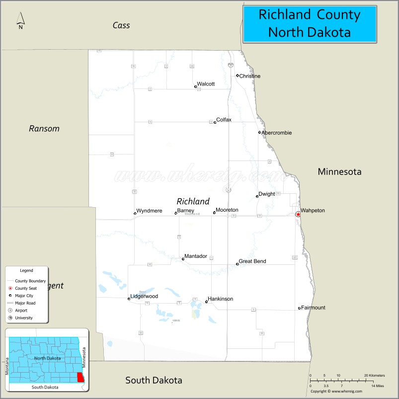
About Richland County Map, North Dakota: The map showing the county boundary, county seat, major cities, highways, water bodies and neighbouring counties.
More North Dakota Maps & Info
About Richland County, North Dakota
Richland County is a county located in the U.S. state of North Dakota. It's county seat is Wahpeton. As per 2020 census, the population of Richland County is 16560 people and population density is square miles. According to the United States Census Bureau, the county has a total area of 1,437 sq mi (3,722 km2). Richland County was established on 1873.
Richland County Facts
| Continent | North America |
| Country | United States |
| State | North Dakota |
| County Seat | Wahpeton |
| Largest City/Town | Wahpeton |
| Established | 1867 |
| Total Area | 1,488.0 sq mi (3,853.9 sq km) |
| Land Area | 1,436.0 sq mi (3,719.2 sq km) |
| Water Area | 52.0 sq mi (134.7 sq km) |
| Population | 15,613 (Census 2020) |
| Population Density | 10.9 people per sq mi |
| Time Zone | Central Time Zone |
| Major Highways | Interstate 29, US Highway 81, North Dakota Highway 11, North Dakota Highway 13, North Dakota Highway 18, North Dakota Highway 46 |
| Major Rivers | Red River of the North, Bois de Sioux River, Wild Rice River |
| Neighboring Counties | Cass, Ransom, Sargent, Wilkin County (Minnesota), Otter Tail County (Minnesota), Grant County (Minnesota) |
| Famous For | Wahpeton, Chahinkapa Zoo, Red River Valley agriculture, North Dakota State College of Science, and the Red River of the North |
| Top Attractions | Chahinkapa Zoo, Chahinkapa Park, Bois de Sioux Golf Course, Wahpeton Wahpper Sculpture, Red Door Art Gallery |
| Official Website | Official Website |
About Richland County, North Dakota
Richland County is located in the southeastern corner of North Dakota and was established in 1867. The county seat and largest city is Wahpeton. Positioned along the Minnesota border, the county lies within the fertile Red River Valley and is known for agriculture, higher education, manufacturing, and recreation. The Red River of the North and Bois de Sioux River help define the county's eastern boundary.
Cities and Towns in Richland County, North Dakota
| City/Town | Population (Census 2020) | Latitude & Longitude |
|---|---|---|
| Wahpeton (county seat) | 8,007 | 46.2652°N, 96.6056°W |
| Hankinson | 919 | 46.0697°N, 96.9020°W |
| Wyndmere | 429 | 46.2580°N, 97.1361°W |
| Lidgerwood | 652 | 46.0764°N, 97.1514°W |
| Colfax | 172 | 46.4719°N, 96.8795°W |
| Abercrombie | 245 | 46.4478°N, 96.7298°W |
| Mooreton | 177 | 46.2780°N, 96.8914°W |
| Barney | 25 | 46.2725°N, 96.9981°W |
| Christine | 153 | 46.5942°N, 96.8145°W |
| Dwight | 83 | 46.3137°N, 96.7419°W |
| Fairmount | 367 | 46.0564°N, 96.6036°W |
| Mantador | 57 | 46.1697°N, 96.9931°W |
Best Golf Courses in Richland County, North Dakota
| Golf Course | Location | Latitude & Longitude |
|---|---|---|
| Bois de Sioux Golf Course | Wahpeton | 46.2608°N, 96.6119°W |
| Fairmount Golf Course | Fairmount | 46.0596°N, 96.6127°W |
| Hankinson Country Club | Hankinson | 46.0662°N, 96.9137°W |
| Oxbow Country Club (near county boundary) | Abercrombie Area | 46.4326°N, 96.7905°W |
What are Major Roads and Highways in Richland County
Major highways connect the county to nearby regions and cities.
- Interstate 29 - major north-south interstate connecting Wahpeton with Fargo, Grand Forks, and South Dakota
- US Highway 81 - parallel route to Interstate 29 serving communities throughout the Red River Valley
- North Dakota Highway 11 - east-west route connecting Wahpeton with Lidgerwood and other southeastern communities
- North Dakota Highway 13 - serves southern portions of the county including Hankinson and Fairmount
- North Dakota Highway 18 - north-south route connecting smaller agricultural communities
- North Dakota Highway 46 - links Richland County with Cass County and western North Dakota
Neighboring Counties of Richland County
- Cass County (north)
- Ransom County (west)
- Sargent County (southwest)
- Wilkin County, Minnesota (east)
- Otter Tail County, Minnesota (southeast)
- Grant County, Minnesota (south)
What are Top Attractions in Richland County, North Dakota
The county offers a mix of natural and cultural attractions.
| Main Sight Name | City | Famous For |
|---|---|---|
| Chahinkapa Zoo | Wahpeton | One of North Dakota's leading zoos with diverse animal exhibits |
| Chahinkapa Park | Wahpeton | Historic park with trails, recreation, and picnic areas |
| Bois de Sioux Golf Course | Wahpeton | Historic golf course spanning North Dakota and Minnesota |
| Wahpper Sculpture | Wahpeton | Large catfish sculpture and city landmark |
| Red Door Art Gallery | Wahpeton | Regional art exhibits and cultural events |
| North Dakota State College of Science | Wahpeton | Historic educational institution founded in 1903 |
| Richland County Historical Museum | Wahpeton | Local history and pioneer collections |
| Bois de Sioux River | Wahpeton | Fishing, kayaking, and scenic views |
| Abercrombie Historic Area | Abercrombie | Historic Red River Valley settlement sites |
| Hankinson Hills Recreation Area | Hankinson | Outdoor activities and prairie scenery |
| Red River Valley Scenic Drives | Countywide | Agricultural landscapes and wildlife viewing |
| Fairmount Community Recreation Area | Fairmount | Parks and outdoor recreation |
Distance from Richland County to Nearby Cities
The following distances are measured by road (driving).
- Wahpeton to Hankinson (Richland County), North Dakota - 20 mi (32 km)
- Wahpeton to Wyndmere (Richland County), North Dakota - 28 mi (45 km)
- Wahpeton to Lidgerwood (Richland County), North Dakota - 35 mi (56 km)
- Wahpeton to Abercrombie (Richland County), North Dakota - 13 mi (21 km)
- Wahpeton to Breckenridge (Wilkin County), Minnesota - 2 mi (3 km)
- Wahpeton to Fergus Falls (Otter Tail County), Minnesota - 52 mi (84 km)
- Wahpeton to Lisbon (Ransom County), North Dakota - 42 mi (68 km)
- Wahpeton to Forman (Sargent County), North Dakota - 36 mi (58 km)
- Wahpeton to Fargo (Cass County), North Dakota - 55 mi (89 km)
- Wahpeton to Valley City (Barnes County), North Dakota - 73 mi (117 km)
- Wahpeton to Jamestown (Stutsman County), North Dakota - 128 mi (206 km)
- Wahpeton to Grand Forks (Grand Forks County), North Dakota - 140 mi (225 km)
- Wahpeton to Devils Lake (Ramsey County), North Dakota - 196 mi (315 km)
- Wahpeton to Bismarck (Burleigh County), North Dakota - 245 mi (394 km)
- Wahpeton to Aberdeen (Brown County), South Dakota - 98 mi (158 km)
References
- QuickFacts - U.S. Census Bureau
- United States Census Bureau
- United States Geological Survey (USGS)
- National Geodetic Survey
- Official County Website
- Adams County Map
- Barnes County Map
- Benson County Map
- Billings County Map
- Bottineau County Map
- Bowman County Map
- Burke County Map
- Burleigh County Map
- Cass County Map
- Cavalier County Map
- Dickey County Map
- Divide County Map
- Dunn County Map
- Eddy County Map
- Emmons County Map
- Foster County Map
- Golden Valley County Map
- Grand Forks County Map
- Grant County Map
- Griggs County Map
- Hettinger County Map
- Kidder County Map
- LaMoure County Map
- Logan County Map
- McHenry County Map
- McKenzie County Map
- McLean County Map
- McIntosh County Map
- Mercer County Map
- Morton County Map
- Mountrail County Map
- Nelson County Map
- Oliver County Map
- Pembina County Map
- Pierce County Map
- Ramsey County Map
- Ransom County Map
- Renville County Map
- Richland County Map
- Rolette County Map
- Sargent County Map
- Sheridan County Map
- Sioux County Map
- Slope County Map
- Stark County Map
- Steele County Map
- Stutsman County Map
- Towner County Map
- Traill County Map
- Walsh County Map
- Ward County Map
- Wells County Map
- Williams County Map
- Alabama Counties
- Alaska boroughs
- Arizona Counties
- Arkansas Counties
- California County Map
- Colorado Counties
- Connecticut Counties
- Delaware Counties
- Florida County Map
- Georgia County Map
- Hawaii Counties
- Idaho Counties
- Illinois Counties
- Indiana Counties
- Iowa Counties
- Kansas Counties
- Kentucky Counties
- Louisiana Counties
- Maine Counties
- Maryland Counties
- Massachusetts Counties
- Michigan County Map
- Minnesota Counties
- Mississippi Counties
- Missouri Counties
- Montana Counties
- Nebraska Counties
- Nevada Counties
- New York Counties
- New Hampshire Counties
- New Jersey Counties
- New Mexico Counties
- North Carolina Counties
- North Dakota Counties
- Ohio County Map
- Oklahoma Counties
- Oregon Counties
- Pennsylvania Counties
- Rhode Island Counties
- South Carolina Counties
- South Dakota Counties
- Map of Tennessee
- Texas County Map
- Utah Counties
- Vermont Counties
- Virginia Counties
- Washington Counties
- West Virginia Counties
- Wisconsin Counties
- Wyoming Counties