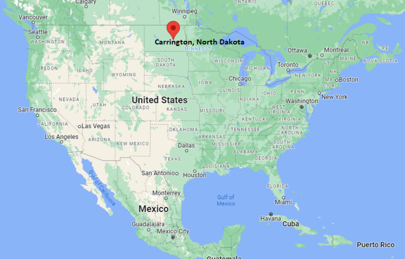
Where is Carrington Located? - Carrington is a city located in the Foster County of North Dakota, United States. Carrington lies between 42.8256141 Degrees North latitudes and 78.8233664 Degrees West longitudes.
Location Map of Carrington, North Dakota
Carrington Map, North Dakota, USA
Where is Carrington?: The Google Map showing the location of Carrington in the U.S. state of North Dakota.
Where is Carrington Located?
Carrington is a city located in the Foster County of North Dakota, United States. Carrington lies between 42.8256141 Degrees North latitudes and 78.8233664 Degrees West longitudes. According to 2020 U.S.census, the population of Carrington city is 2080 people and the city has a total area of 2.32 sq mi. The city has numerous parks and recreational facilities.
Nearby Cities and Towns to Carrington, North Dakota
New Rockford, North Dakota - 28 mi
Grace City, North Dakota - 31 mi
Harvey, North Dakota - 39 mi
Glenfield, North Dakota - 17 mi
McHenry, North Dakota - 23 mi
Jamestown, North Dakota - 43 mi
Fessenden, North Dakota - 52 mi
Cooperstown, North Dakota - 55 mi
Devils Lake, North Dakota - 74 mi
Bismarck, North Dakota - 128 mi
Carrington, North Dakota Climate and Weather Overview
Month
Avg High (°F)
Avg Low (°F)
Avg Rainfall (in)
January
19
1
0.5
April
55
29
1.3
July
82
57
3.0
October
56
33
1.2
Annual
53
31
19.5
Climate Attribute
Details
Climate Classification (Köppen)
Warm-Summer Humid Continental (Dfb)
Annual Rainfall
About 19.5 in
Annual Sunshine Days
About 201 days
Hurricane/Tornado Risk
No hurricane risk and low tornado risk
Snowfall
About 39 in annually
Driving Distances from Carrington, North Dakota
City
State
Distance (mi)
Approx. Drive Time
Glenfield
North Dakota
17
20 min
McHenry
North Dakota
23
25 min
New Rockford
North Dakota
28
30 min
Grace City
North Dakota
31
35 min
Harvey
North Dakota
39
40 min
Jamestown
North Dakota
43
45 min
Fessenden
North Dakota
52
55 min
Cooperstown
North Dakota
55
1 hr
Devils Lake
North Dakota
74
1 hr 15 min
Bismarck
North Dakota
128
2 hr
Transportation and Connectivity in Carrington, North Dakota
Transportation
Details
Airport Name
Carrington Municipal Airport
IATA Code
No scheduled commercial service
Port
No commercial port
Major Highways
U.S. Highway 281, North Dakota Highway 200, North Dakota Highway 52
Train/Amtrak Service
No passenger rail service; nearest Amtrak station in Devils Lake
Local Bus/Transit Service
Regional transportation services available by appointment
U.S. Highway 281 and North Dakota Highway 200 make Carrington an important transportation hub in central North Dakota.
Carrington Municipal Airport supports general aviation, agricultural aviation, and business flights.
The nearest commercial air service is available at Jamestown Regional Airport and Bismarck Municipal Airport.
Regional highways provide convenient access to Jamestown, Devils Lake, Bismarck, and surrounding farming communities.
Carrington serves as an agricultural, educational, and healthcare center for Foster County and the surrounding prairie region.
Key Landmarks and Places to Visit in Carrington, North Dakota
Landmark Name
Type
Carrington City Park
Community Park
CrossRoads Golf Course
Golf Course
Arrowwood National Wildlife Refuge
National Wildlife Refuge
Foster County Museum
History Museum
Carrington Country Club
Country Club
Arrowwood National Wildlife Refuge Visitor Area
Wildlife Viewing Area
Carrington Park District Recreation Center
Recreation Center
Sykeston Dam Recreation Area
Outdoor Recreation Area
Jamestown Reservoir
Reservoir
Stutsman County Memorial Museum
Museum
Colleges and Universities near Carrington, North Dakota
Institution Name
Type
Level
Notable For
University of Jamestown
Private
University
Liberal arts, business, nursing, and education
Lake Region State College
Public
Community College
Career training, liberal arts, and workforce education
North Dakota State College of Science
Public
Community College
Technical, trade, and applied science programs
Bismarck State College
Public
Community College
Energy, technology, business, and healthcare programs
University of North Dakota
Public
University
Research, engineering, aviation, and medicine
Waterbodies in Carrington, North Dakota
Arrowwood Lake, James River, Pipestem Creek, Lake George, Sibley Lake, New Johns Lake, Chase Lake, Horsehead Lake
Golf Courses near Carrington, North Dakota
CrossRoads Golf Course, Jamestown Country Club, Harvey Country Club, Rugby Golf Club, Edgewood Golf Course, New Rockford Golf Club, Heart of America Golf Course, Lake Region Golf Club
Carrington, North Dakota - Key Historical Facts
Carrington was founded in 1883 following the arrival of the Northern Pacific Railroad, which helped establish the community as a regional transportation and trade center.
The city was named after George H. Carrington, a railroad official who played a role in the area's early railroad development.
Agriculture quickly became the foundation of the local economy, with wheat, barley, sunflowers, and livestock production supporting the surrounding region.
Carrington developed into the county seat of Foster County, attracting businesses, schools, healthcare facilities, and government services.
The nearby Arrowwood National Wildlife Refuge has become an important destination for birdwatching, hunting, fishing, and wildlife conservation.
Today, Carrington is recognized for its agricultural research, rural healthcare, outdoor recreation, and role as an economic hub in central North Dakota.