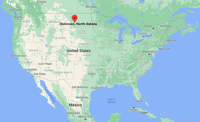
Where is Dickinson Located? - Dickinson is a city located in the Stark County of North Dakota, United States. Dickinson lies between 40.8014876 Degrees North latitudes and 72.8676033 Degrees West longitudes.
Location Map of Dickinson, North Dakota
Dickinson Map, North Dakota, USA
Where is Dickinson?: The Google Map showing the location of Dickinson in the U.S. state of North Dakota.
Where is Dickinson Located?
Dickinson is a city located in the Stark County of North Dakota, United States. Dickinson lies between 40.8014876 Degrees North latitudes and 72.8676033 Degrees West longitudes. According to 2020 U.S.census, the population of Dickinson city is 25679 people and the city has a total area of 14.14 sq mi. The city has numerous parks and recreational facilities.
Dickinson, North Dakota Climate and Weather Overview
Month
Avg High (°F)
Avg Low (°F)
Avg Rainfall (in)
January
24
4
0.5
April
56
30
1.2
July
84
56
2.3
October
58
33
0.9
Annual
56
32
17.4
Climate Attribute
Details
Climate Classification (Köppen)
Warm-Summer Humid Continental (Dfb)
Annual Rainfall
About 17.4 inches
Annual Sunshine Days
Approximately 205 days
Hurricane/Tornado Risk
No hurricane risk; low tornado risk
Snowfall
About 39 inches annually
Driving Distances from Dickinson, North Dakota
City
State
Distance (mi)
Approx. Drive Time
South Heart
North Dakota
8
10 min
Gladstone
North Dakota
10
12 min
Taylor
North Dakota
13
15 min
Belfield
North Dakota
16
18 min
Richardton
North Dakota
25
25 min
Killdeer
North Dakota
51
55 min
Beach
North Dakota
63
1 hr
Watford City
North Dakota
73
1 hr 15 min
Mandan
North Dakota
98
1 hr 30 min
Bismarck
North Dakota
102
1 hr 35 min
Transportation and Connectivity in Dickinson, North Dakota
Transportation
Details
Airport Name
Dickinson Theodore Roosevelt Regional Airport
IATA Code
DIK
Port
No commercial port
Major Highways
Interstate 94, US Highway 85, North Dakota Highway 22
Train/Amtrak Service
No passenger rail service; nearest Amtrak station is in Williston
Local Bus/Transit Service
Demand-response public transit and Jefferson Lines intercity bus service
Interstate 94 is the primary east-west highway connecting Dickinson with Bismarck, Fargo, Billings, and other regional destinations.
US Highway 85 provides an important north-south route linking the city with Watford City, Williston, South Dakota, and the Bakken oil region.
North Dakota Highway 22 connects Dickinson with Killdeer and communities throughout western North Dakota.
Dickinson Theodore Roosevelt Regional Airport offers scheduled commercial flights and supports business and general aviation throughout the region.
Key Landmarks and Places to Visit in Dickinson, North Dakota
Landmark Name
Type
Dakota Dinosaur Museum
Museum
Dickinson Museum Center
Museum Complex
Patterson Lake Recreation Area
Recreation Area
Theodore Roosevelt Center at Dickinson State University
Research Center
Ukrainian Cultural Institute
Cultural Museum
West River Community Center
Recreation Center
Prairie Outpost Park
Historical Park
Heart River Golf Course
Golf Course
Theodore Roosevelt National Park (South Unit)
National Park
Downtown Dickinson Historic District
Historic District
Colleges and Universities in Dickinson, North Dakota
Institution Name
Type
Level
Notable For
Dickinson State University
Public
University
Business, education, nursing, and applied sciences
Bismarck State College - Dickinson Site
Public
Community College
Technical and workforce education
University of Mary (nearby programs)
Private
University
Graduate and professional studies
North Dakota State University Extension
Public
Extension Education
Agriculture and community outreach
Dickinson Public Schools
Public
K-12 District
Public education system
Waterbodies in Dickinson, North Dakota
Heart River, Patterson Lake, Green River, Lake Tschida, Dickinson Reservoir, Rocky Butte Creek, Antelope Creek, Green River Reservoir
Golf Courses in Dickinson, North Dakota
Heart River Golf Course, Bully Pulpit Golf Course, Hawktree Golf Club, Prairie West Golf Course, Watford City Golf Club, Medicine Hole Golf Course
Dickinson, North Dakota - Key Historical Facts
Dickinson was founded in 1881 along the Northern Pacific Railway and was named after Wells S. Dickinson, a railroad executive.
The city quickly became an important shipping and trade center for ranching, farming, and livestock production across western North Dakota.
Its location near the Badlands made Dickinson a gateway for settlers, ranchers, and travelers heading west during the late 19th century.
The discovery and development of the Bakken oil formation in the early 21st century brought rapid economic growth, population increases, and commercial expansion.
Dickinson State University, established in 1918, has played an important role in higher education and workforce development throughout the region.
Today, Dickinson serves as the economic and cultural hub of southwestern North Dakota, known for its energy industry, agriculture, tourism, and proximity to Theodore Roosevelt National Park.