Map of Acadia Parish - Acadia Parish is a county located in the U.S. state of Louisiana. Acadia Parish Map showing cities, highways, important places and water bodies. Get Where is Acadia Parish located in the map, major cities in Acadia Parish, population, areas, and places of interest.
Map of Acadia Parish, Louisiana
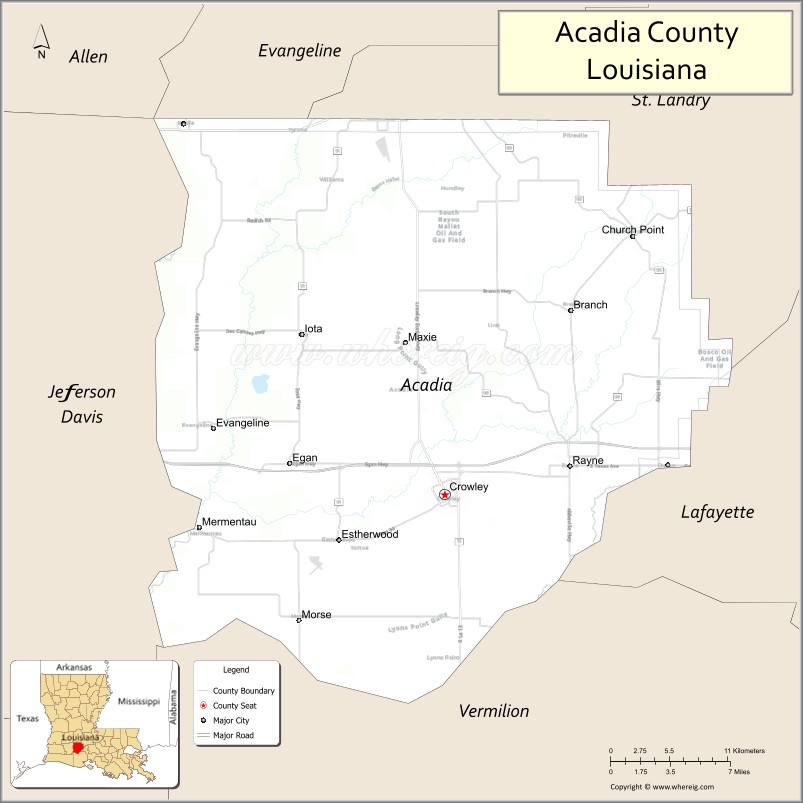
About Acadia Parish Map, Louisiana: The map showing the county boundary, county seat, major cities, highways, water bodies and neighbouring counties.
More Louisiana Maps
Map of Acadia Parish, Louisiana
Acadia Parish County is a county located in the U.S. state of Louisiana. It's county seat is Crowley. As per 2020 census, the population of Acadia Parish County is 57288 people and population density is square miles. According to the United States Census Bureau, the county has a total area of 658 sq mi (1,704 km2). Acadia Parish County was established on 1886.
Acadia Parish Facts
| Continent | North America |
| Country | United States |
| State | Louisiana |
| County Seat | Crowley |
| Largest City/Town | Crowley |
| Established | 1886 |
| Total Area | 657 sq mi (1,701 sq km) |
| Land Area | 655 sq mi (1,696 sq km) |
| Water Area | 2 sq mi (5 sq km) |
| Population | 57,576 (Census 2020) |
| Population Density | 87.9 people per sq mi |
| Time Zone | Central Time Zone (CT) |
| Major Highways | Interstate 10, U.S. Route 90, Louisiana Highway 13, Louisiana Highway 35 |
| Major Rivers | Mermentau River, Bayou Plaquemine Brule |
| Neighboring Counties | Evangeline Parish, St. Landry Parish, Lafayette Parish, Jefferson Davis Parish, Vermilion Parish |
| Famous For | Cajun culture, rice farming, Frog Festival, historic downtown Crowley |
| Top Attractions | Crowley Rice Festival Grounds, Le Vieux Presbytere Museum, Bayou Plaquemine Brule, Martin Luther King Center, Grand Opera House of the South |
| Official Website | Official Website |
About Acadia Parish, Louisiana
Acadia Parish is located in the southwestern part of Louisiana in the United States and was established in 1886. The parish seat is Crowley, which is also the largest city. The area is known for its flat prairie landscape, rice fields, and strong Cajun cultural traditions that continue to shape local festivals, food, and music.
Cities and Towns in Acadia Parish, Louisiana
| City/Town | Population (Census 2020) | Latitude & Longitude |
|---|---|---|
| Crowley (county seat) | 11,710 | 30.2141°N, 92.3746°W |
| Rayne | 7,459 | 30.2341°N, 92.2687°W |
| Church Point | 4,877 | 30.4027°N, 92.2154°W |
| Eunice | 10,398 | 30.4941°N, 92.4176°W |
| Iota | 1,381 | 30.3319°N, 92.4951°W |
| Morse | 759 | 30.1430°N, 92.4993°W |
| Estherwood | 857 | 30.1819°N, 92.4643°W |
| Mermentau | 692 | 30.1810°N, 92.5829°W |
| Midland | 1,273 | 30.1802°N, 92.5018°W |
| Basile | 1,540 | 30.4855°N, 92.5951°W |
| Branch | 1,282 | 30.3391°N, 92.3082°W |
| Egan (CDP) | 631 | 30.2369°N, 92.4049°W |
Golf Courses in Acadia Parish, Louisiana
| Golf Course | Location | Latitude & Longitude |
|---|---|---|
| Bayou Bend Country Club | Crowley | 30.2308°N, 92.3808°W |
| Rice Palace Golf Course | Crowley | 30.1984°N, 92.3625°W |
Roads and Highways in Acadia Parish, Louisiana
Major highways connect the parish to nearby regions and cities.
- Interstate 10 - runs east-west through the parish and connects Crowley with Lafayette and Lake Charles
- U.S. Route 90 - links local communities with Lafayette and Jennings
- Louisiana Highway 13 - connects Crowley with Eunice and Kaplan
- Louisiana Highway 35 - travels north-south through Rayne and Church Point
- Louisiana Highway 91 - provides access to rural farming communities
Neighboring Counties of Acadia Parish
- Evangeline Parish (north)
- St. Landry Parish (northeast)
- Lafayette Parish (east)
- Vermilion Parish (south)
- Jefferson Davis Parish (west)
Top Attractions in Acadia Parish, Louisiana
The parish offers a mix of natural and cultural attractions.
- Grand Opera House of the South - historic theater in Crowley dating back to 1901
- International Rice Festival Grounds - annual festival site celebrating the local rice industry
- Le Vieux Presbytere Museum - museum showcasing Cajun history and culture
- Rayne Frog Festival Area - famous event celebrating Rayne as the Frog Capital of the World
- Bayou Plaquemine Brule - scenic bayou popular for fishing and wildlife viewing
- St. Michael Catholic Church - historic church in Crowley with impressive architecture
- Crowley Historic District - downtown area with preserved historic buildings and shops
- Martin Luther King Center - community and cultural center in Crowley
- Church Point Cajun Music Hall - venue for local Cajun music performances
- Rice Theatre Area - cultural and entertainment location in downtown Crowley
Distance from Acadia Parish to Nearby Cities
The following distances are measured by road (driving).
- Crowley to Lafayette (Lafayette Parish), Louisiana - 27 mi (43 km)
- Crowley to Lake Charles (Calcasieu Parish), Louisiana - 63 mi (101 km)
- Crowley to Baton Rouge (East Baton Rouge Parish), Louisiana - 85 mi (137 km)
- Crowley to New Orleans (Orleans Parish), Louisiana - 160 mi (257 km)
- Crowley to Jennings (Jefferson Davis Parish), Louisiana - 28 mi (45 km)
- Crowley to Opelousas (St. Landry Parish), Louisiana - 42 mi (68 km)
- Crowley to Eunice (St. Landry Parish), Louisiana - 26 mi (42 km)
- Crowley to Abbeville (Vermilion Parish), Louisiana - 38 mi (61 km)
- Crowley to Alexandria (Rapides Parish), Louisiana - 105 mi (169 km)
- Crowley to Beaumont (Jefferson County), Texas - 118 mi (190 km)
- Crowley to Houston (Harris County), Texas - 205 mi (330 km)
- Crowley to Shreveport (Caddo Parish), Louisiana - 226 mi (364 km)
FAQs about Acadia Parish
Acadia Parish is located in southwestern Louisiana between Lafayette and Lake Charles in the Cajun Prairie region.
Acadia Parish has a population of 57,576 according to the Census 2020.
The parish is known for Cajun culture, rice farming, the International Rice Festival, and historic small towns.
Major highways include Interstate 10, U.S. Route 90, Louisiana Highway 13, and Louisiana Highway 35.
Yes, Acadia Parish has golf facilities including Bayou Bend Country Club and Rice Palace Golf Course in Crowley.
References
- QuickFacts - U.S. Census Bureau
- United States Census Bureau
- United States Geological Survey (USGS)
- National Geodetic Survey
- Official County Website
- Acadia Parish Map
- Allen Parish Map
- Ascension Parish Map
- Assumption Parish Map
- Avoyelles Parish Map
- Beauregard Parish Map
- Bienville Parish Map
- Bossier Parish Map
- Caddo Parish Map
- Calcasieu Parish Map
- Caldwell Parish Map
- Cameron Parish Map
- Catahoula Parish Map
- Claiborne Parish Map
- Concordia Parish Map
- De Soto Parish Map
- East Baton Rouge Parish Map
- East Carroll Parish Map
- East Feliciana Parish Map
- Evangeline Parish Map
- Franklin Parish Map
- Grant Parish Map
- Iberia Parish Map
- Iberville Parish Map
- Jackson Parish Map
- Jefferson Parish Map
- Jefferson Davis Parish Map
- Lafayette Parish Map
- Lafourche Parish Map
- LaSalle Parish Map
- Lincoln Parish Map
- Livingston Parish Map
- Madison Parish Map
- Morehouse Parish Map
- Natchitoches Parish Map
- Orleans Parish Map
- Ouachita Parish Map
- Plaquemines Parish Map
- Pointe Coupee Parish Map
- Rapides Parish Map
- Red River Parish Map
- Richland Parish Map
- Sabine Parish Map
- St Bernard Parish Map
- St Charles Parish Map
- St Helena Parish Map
- St James Parish Map
- St John the Baptist Parish Map
- St Landry Parish Map
- St Martin Parish Map
- St Mary Parish Map
- St Tammany Parish Map
- Tangipahoa Parish Map
- Tensas Parish Map
- Terrebonne Parish Map
- Union Parish Map
- Vermilion Parish Map
- Vernon Parish Map
- Washington Parish Map
- Webster Parish Map
- West Baton Rouge Parish Map
- West Carroll Parish Map
- West Feliciana Parish Map
- Winn Parish Map
- Alabama Counties
- Alaska boroughs
- Arizona Counties
- Arkansas Counties
- California County Map
- Colorado Counties
- Connecticut Counties
- Delaware Counties
- Florida County Map
- Georgia County Map
- Hawaii Counties
- Idaho Counties
- Illinois Counties
- Indiana Counties
- Iowa Counties
- Kansas Counties
- Kentucky Counties
- Louisiana Counties
- Maine Counties
- Maryland Counties
- Massachusetts Counties
- Michigan County Map
- Minnesota Counties
- Mississippi Counties
- Missouri Counties
- Montana Counties
- Nebraska Counties
- Nevada Counties
- New York Counties
- New Hampshire Counties
- New Jersey Counties
- New Mexico Counties
- North Carolina Counties
- North Dakota Counties
- Ohio County Map
- Oklahoma Counties
- Oregon Counties
- Pennsylvania Counties
- Rhode Island Counties
- South Carolina Counties
- South Dakota Counties
- Map of Tennessee
- Texas County Map
- Utah Counties
- Vermont Counties
- Virginia Counties
- Washington Counties
- West Virginia Counties
- Wisconsin Counties
- Wyoming Counties