Map of Allen Parish - Allen Parish is a county located in the U.S. state of Louisiana. Allen Parish Map showing cities, highways, important places and water bodies. Get Where is Allen Parish located in the map, major cities in Allen Parish, population, areas, and places of interest.
Map of Allen Parish, Louisiana
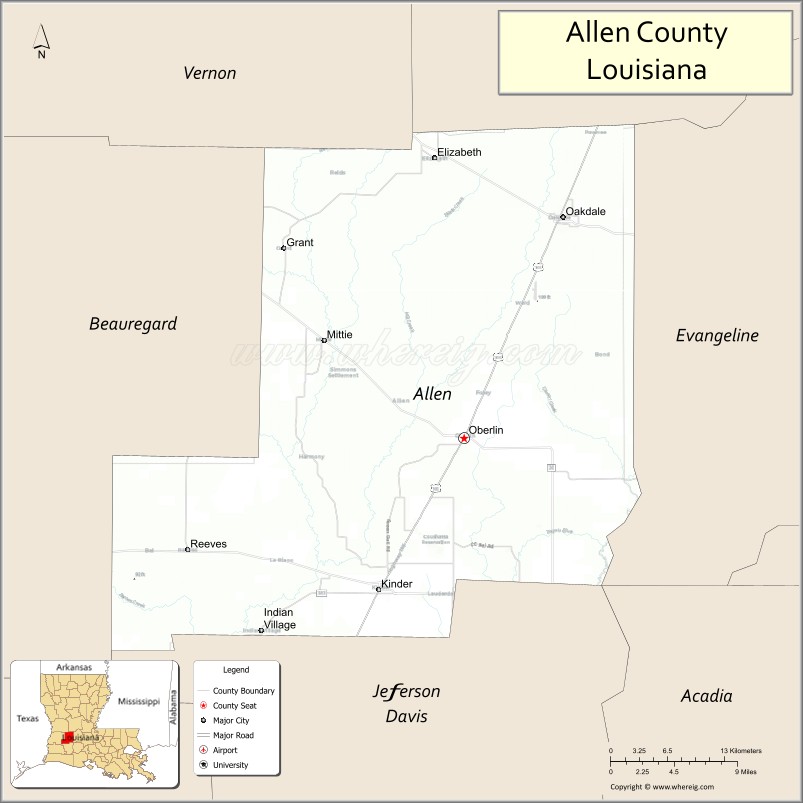
About Allen Parish Map, Louisiana: The map showing the county boundary, county seat, major cities, highways, water bodies and neighbouring counties.
More Louisiana Maps
Map of Allen Parish, Louisiana
Allen Parish County is a county located in the U.S. state of Louisiana. It's county seat is Oberlin. As per 2020 census, the population of Allen Parish County is 22687 people and population density is square miles. According to the United States Census Bureau, the county has a total area of 766 sq mi (1,984 km2). Allen Parish County was established on 1912.
Allen Parish Facts
| County Info | Facts |
|---|---|
| County | Allen Parish |
| County Seat | Oberlin |
| State | Louisiana |
| Country | United States |
| FIPS code | 3 |
| Established | 1912 |
| Area | 766 sq mi (1,984 km2) |
| Population | 22687 |
| Density | |
| Formed / Origin | from part of Calcasieu Parish. |
Ctities in Allen Parish county
| City Name | Type | Population (2020) | Pop. Density | Area | Incorporated |
|---|---|---|---|---|---|
| Elizabeth | Town | 417 | 0.0/sq mi (0.0/km2) | 1.64 sq mi (4.2 km2) | 1964 |
| Kinder | Town | 2,170 | 0.0/sq mi (0.0/km2) | 5.53 sq mi (14.3 km2) | 1903 |
| Oakdale | City | 6,692 | 0.0/sq mi (0.0/km2) | 5.19 sq mi (13.4 km2) | 1913 |
| Oberlin | Town | 1,402 | 0.0/sq mi (0.0/km2) | 4.38 sq mi (11.3 km2) | 1900 |
| Reeves | Village | 221 | 0.0/sq mi (0.0/km2) | 2.42 sq mi (6.3 km2) | 1911 |
- Acadia Parish Map
- Allen Parish Map
- Ascension Parish Map
- Assumption Parish Map
- Avoyelles Parish Map
- Beauregard Parish Map
- Bienville Parish Map
- Bossier Parish Map
- Caddo Parish Map
- Calcasieu Parish Map
- Caldwell Parish Map
- Cameron Parish Map
- Catahoula Parish Map
- Claiborne Parish Map
- Concordia Parish Map
- De Soto Parish Map
- East Baton Rouge Parish Map
- East Carroll Parish Map
- East Feliciana Parish Map
- Evangeline Parish Map
- Franklin Parish Map
- Grant Parish Map
- Iberia Parish Map
- Iberville Parish Map
- Jackson Parish Map
- Jefferson Parish Map
- Jefferson Davis Parish Map
- Lafayette Parish Map
- Lafourche Parish Map
- LaSalle Parish Map
- Lincoln Parish Map
- Livingston Parish Map
- Madison Parish Map
- Morehouse Parish Map
- Natchitoches Parish Map
- Orleans Parish Map
- Ouachita Parish Map
- Plaquemines Parish Map
- Pointe Coupee Parish Map
- Rapides Parish Map
- Red River Parish Map
- Richland Parish Map
- Sabine Parish Map
- St Bernard Parish Map
- St Charles Parish Map
- St Helena Parish Map
- St James Parish Map
- St John the Baptist Parish Map
- St Landry Parish Map
- St Martin Parish Map
- St Mary Parish Map
- St Tammany Parish Map
- Tangipahoa Parish Map
- Tensas Parish Map
- Terrebonne Parish Map
- Union Parish Map
- Vermilion Parish Map
- Vernon Parish Map
- Washington Parish Map
- Webster Parish Map
- West Baton Rouge Parish Map
- West Carroll Parish Map
- West Feliciana Parish Map
- Winn Parish Map
- Alabama Counties
- Alaska boroughs
- Arizona Counties
- Arkansas Counties
- California County Map
- Colorado Counties
- Connecticut Counties
- Delaware Counties
- Florida County Map
- Georgia County Map
- Hawaii Counties
- Idaho Counties
- Illinois Counties
- Indiana Counties
- Iowa Counties
- Kansas Counties
- Kentucky Counties
- Louisiana Counties
- Maine Counties
- Maryland Counties
- Massachusetts Counties
- Michigan County Map
- Minnesota Counties
- Mississippi Counties
- Missouri Counties
- Montana Counties
- Nebraska Counties
- Nevada Counties
- New York Counties
- New Hampshire Counties
- New Jersey Counties
- New Mexico Counties
- North Carolina Counties
- North Dakota Counties
- Ohio County Map
- Oklahoma Counties
- Oregon Counties
- Pennsylvania Counties
- Rhode Island Counties
- South Carolina Counties
- South Dakota Counties
- Map of Tennessee
- Texas County Map
- Utah Counties
- Vermont Counties
- Virginia Counties
- Washington Counties
- West Virginia Counties
- Wisconsin Counties
- Wyoming Counties