
Where is Fort Smith Located? - Fort Smith is a city located in the Sebastian County of Arkansas, United States. Fort Smith lies between 34.5292 Degrees North latitudes and 90.5912 Degrees West longitudes.
Location Map of Fort Smith, Arkansas
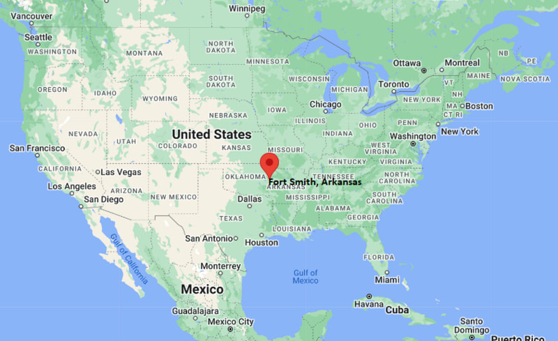
Fort Smith Map, Arkansas, USA
Where is Fort Smith?: The Google Map showing the location of Fort Smith in the U.S. state of Arkansas.
Where is Fort Smith Located?
Fort Smith is a city located in the Sebastian County of Arkansas, United States. Fort Smith lies between 34.5292 Degrees North latitudes and 90.5912 Degrees West longitudes. According to 2020 U.S.census, the population of Fort Smith city is 89142 people and the city has a total area of 63.29 sq mi. The city has numerous parks and recreational facilities.
Most Viewed US Maps
| USA Sttae Map | USA Region Map | USA Road Map |
| USA County Map | Where is USA in World Map? | US ZIP Code Map |
| USA Time Zones Map | US State and Capitals Map | USA Physical Map |
Find 4,400+ U.S. Cities by State - Explore Their Locations and Get Detailed Information
Fort Smith, Arkansas Quick Facts
| Property | Information |
|---|---|
| City | Fort Smith |
| County | Sebastian County |
| State | Arkansas |
| State Capital | Little Rock |
| US Region | Southern United States |
| Latitude | 35.3859° N |
| Longitude | 94.3985° W |
| Elevation | 404 ft (123 m) |
| Land Area | 64.06 sq mi |
| Water Area | 2.41 sq mi |
| Total Area | 66.47 sq mi |
| Population (latest Census year) | 89,142 (2020 Census) |
| Population Density | 1,391 per sq mi |
| ZIP Codes | 72901, 72902, 72903, 72904, 72905, 72906, 72908, 72916 |
| Area Code | 479 |
| Time Zone Standard | Central Standard Time (CST, UTC−6) |
| Time Zone Daylight | Central Daylight Time (CDT, UTC−5) |
| Currency | US Dollar (USD) |
| FIPS Code | 05-24550 |
| Congressional District | 3rd Congressional District |
Nearby Cities to Fort Smith, Arkansas
- Van Buren, Arkansas — 6 mi West
- Barling, Arkansas — 7 mi Southeast
- Alma, Arkansas — 13 mi Northeast
- Greenwood, Arkansas — 14 mi South
- Ozark, Arkansas — 35 mi East
- Poteau, Oklahoma — 25 mi West
- Fayetteville, Arkansas — 55 mi Northwest
- Russellville, Arkansas — 70 mi East
- Tulsa, Oklahoma — 110 mi Northwest
- Little Rock, Arkansas — 160 mi East
Driving Distances from Fort Smith, Arkansas
| City | State | Distance (mi) | Approx. Drive Time |
|---|---|---|---|
| Van Buren | Arkansas | 6 | 10 min |
| Barling | Arkansas | 7 | 12 min |
| Alma | Arkansas | 13 | 20 min |
| Greenwood | Arkansas | 14 | 20 min |
| Poteau | Oklahoma | 25 | 35 min |
| Ozark | Arkansas | 35 | 45 min |
| Fayetteville | Arkansas | 55 | 1 hr |
| Russellville | Arkansas | 70 | 1 hr 20 min |
| Tulsa | Oklahoma | 110 | 1 hr 50 min |
| Little Rock | Arkansas | 160 | 2 hr 30 min |
Transportation and Connectivity in Fort Smith, Arkansas
| Category | Information |
|---|---|
| Airport Name | Fort Smith Regional Airport |
| IATA Code | FSM |
| Port | Arkansas River Navigation System |
| Major Highways | Interstate 40, U.S. Route 64, U.S. Route 71, Arkansas Highway 22 |
| Train/Amtrak Service | No direct Amtrak service; nearest stations are in Oklahoma |
| Local Bus/Transit Service | Fort Smith Transit |
- Interstate 40 connects Fort Smith with major cities including Little Rock, Oklahoma City, and Memphis.
- U.S. Route 71 provides important north-south access through western Arkansas.
- Fort Smith Regional Airport provides commercial air service for the Arkansas River Valley region.
- The city's location along the Arkansas River has supported transportation, trade, and industrial development for more than a century.
What are top Places to Visit in Fort Smith, Arkansas
| Landmark Name | Type |
|---|---|
| Fort Smith National Historic Site | Historic Site |
| Miss Laura's Social Club | Historic Building |
| Fort Smith Museum of History | History Museum |
| Fort Smith Regional Art Museum | Art Museum |
| Parrot Island Waterpark | Water Park |
| Janet Huckabee Arkansas River Valley Nature Center | Nature Center |
| Riverfront Park | Riverfront Recreation Area |
| Massard Prairie Battlefield Park | Historic Battlefield |
| Ben Geren Regional Park | Regional Park |
| Fort Smith Trolley Museum | Transportation Museum |
Colleges and Universities in Fort Smith, Arkansas
| Institution Name | Type | Level | Notable For |
|---|---|---|---|
| University of Arkansas - Fort Smith | Public | University | Health sciences, business, applied science, technology and workforce education |
| Arkansas Colleges of Health Education | Private | Health Sciences Institution | Osteopathic medicine, physical therapy and healthcare education |
| NorthWest Arkansas Community College - Fort Smith Programs | Public | Community Education | Workforce training and professional development programs |
| Fort Smith Public Schools | Public | K–12 District | Public education serving Fort Smith students and families |
Waterbodies in Fort Smith, Arkansas
Arkansas River, Poteau River, Lee Creek, Massard Creek, Wells Lake, Ben Geren Lake, Frog Bayou, Lake Fort Smith
Golf Courses in Fort Smith, Arkansas
Ben Geren Golf Course, Hardscrabble Country Club, Fianna Hills Country Club, Fort Smith Country Club, Eagle Crest Golf Course
Fort Smith, Arkansas — Key Historical Facts
- Fort Smith was established in 1817 as a military post along the Arkansas River and played an important role in the expansion of the United States into the western frontier.
- The city became a major federal center during the nineteenth century, especially through the operations of the U.S. District Court for the Western District of Arkansas under Judge Isaac Parker.
- Fort Smith was a significant location during the period of Indian Territory development and served as a gateway between Arkansas and present-day Oklahoma.
- During the twentieth century, Fort Smith grew into a major manufacturing and commercial center in western Arkansas, supported by transportation and river trade.
- Today, Fort Smith is the second-largest city in Arkansas and is known for its historic sites, healthcare and education institutions, manufacturing industry, and role as a regional hub for the Arkansas River Valley.
References
- U.S. Census Bureau
- City of Fort Smith
- University of Arkansas - Fort Smith
- Sebastian County Government
Arkansas Related Links
- Where is Arkadelphia
- Where is Batesville
- Where is Beebe
- Where is Benton
- Where is Bentonville
- Where is Blytheville
- Where is Bryant
- Where is Cabot
- Where is Camden
- Where is Centerton
- Where is Clarksville
- Where is Conway
- Where is El Dorado
- Where is Farmington
- Where is Forrest City
- Where is Fort Smith
- Where is Greenwood
- Where is Harrison
- Where is Helena-West Helena
- Where is Hope
- Where is Hot Springs
- Where is Hot Springs Village
- Where is Jonesboro
- Where is Little Rock
- Where is Lowell
- Where is Magnolia
- Where is Malvern
- Where is Marion
- Where is Maumelle
- Where is Monticello
- Where is Mountain Home
- Where is Newport
- Where is North Little Rock
- Where is Paragould
- Where is Pine Bluff
- Where is Pocahontas
- Where is Prairie Grove
- Where is Rogers
- Where is Russellville
- Where is Searcy
- Where is Sherwood
- Where is Siloam Springs
- Where is Springdale
- Where is Stuttgart
- Where is Texarkana
- Where is Van Buren
- Where is West Memphis
- Where is Wynne