
Where is Harmony Located? - Harmony is a city located in the Beaver County of Rhode Island, United States. Harmony lies between 39.8814519 Degrees North latitudes and 83.0929644 Degrees West longitudes.
Location Map of Harmony, Rhode Island
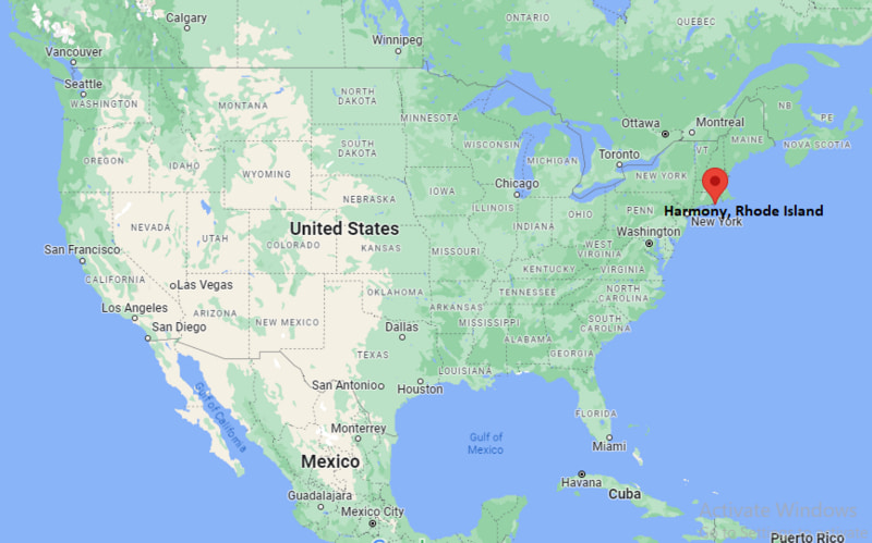
Harmony Map, Rhode Island, USA
Where is Harmony?: The Google Map showing the location of Harmony in the U.S. state of Rhode Island.
Where is Harmony Located?
Harmony is a city located in the Beaver County of Rhode Island, United States. Harmony lies between 39.8814519 Degrees North latitudes and 83.0929644 Degrees West longitudes. According to 2020 U.S.census, the population of Harmony city is 1036 people and the city has a total area of 2.94 sq mi. The city has numerous parks and recreational facilities.
Most Viewed US Maps
| USA Sttae Map | USA Region Map | USA Road Map |
| USA County Map | Where is USA in World Map? | US ZIP Code Map |
| USA Time Zones Map | US State and Capitals Map | USA Physical Map |
Find 4,400+ U.S. Cities by State - Explore Their Locations and Get Detailed Information
Harmony, Rhode Island Quick Facts
| Property | Information |
|---|---|
| Village | Harmony |
| Town | Glocester |
| County | Providence County |
| State | Rhode Island |
| State Capital | Providence |
| US Region | Northeastern United States |
| Latitude | 41.9058°N |
| Longitude | 71.7026°W |
| Elevation | 505 ft (154 m) |
| Land Area | Located within the Town of Glocester (village area not separately measured by the U.S. Census) |
| Water Area | Minimal |
| Total Area | Part of Glocester's 56.8 sq mi |
| Population (latest Census year) | Included within Glocester (Census 2020) |
| Population Density | Not separately reported |
| ZIP Code | 02829 |
| Area Code | 401 |
| Time Zone Standard | Eastern Standard Time (EST, UTC−5) |
| Time Zone Daylight | Eastern Daylight Time (EDT, UTC−4) |
| Currency | US Dollar (USD) |
| FIPS Code | Not separately assigned |
| Congressional District | Rhode Island's 2nd Congressional District |
Nearby Cities to Harmony, Rhode Island
- Chepachet, Rhode Island — 4 mi Southeast
- Pascoag, Rhode Island — 8 mi Northwest
- Greenville, Rhode Island — 10 mi East
- Burrillville, Rhode Island — 11 mi North
- Smithfield, Rhode Island — 12 mi Southeast
- North Scituate, Rhode Island — 12 mi South
- Johnston, Rhode Island — 17 mi Southeast
- Providence, Rhode Island — 22 mi Southeast
- Putnam, Connecticut — 21 mi West
- Woonsocket, Rhode Island — 22 mi Northeast
Driving Distances from Harmony, Rhode Island
| City | State | Distance (mi) | Approx. Drive Time |
|---|---|---|---|
| Chepachet | Rhode Island | 4 | 8 minutes |
| Pascoag | Rhode Island | 8 | 15 minutes |
| Greenville | Rhode Island | 10 | 18 minutes |
| Smithfield | Rhode Island | 12 | 20 minutes |
| North Scituate | Rhode Island | 12 | 20 minutes |
| Providence | Rhode Island | 22 | 35 minutes |
| Woonsocket | Rhode Island | 22 | 35 minutes |
| Putnam | Connecticut | 21 | 35 minutes |
| Warwick | Rhode Island | 28 | 40 minutes |
| Boston | Massachusetts | 62 | 1 hour 15 minutes |
Transportation and Connectivity in Harmony, Rhode Island
| Transportation | Details |
|---|---|
| Airport Name | Rhode Island T. F. Green International Airport |
| IATA Code | PVD |
| Port | Port of Providence (regional) |
| Major Highways | Rhode Island Route 44, Rhode Island Route 94, Interstate 295 (nearby), Interstate 395 (via Connecticut) |
| Train/Amtrak Service | Nearest Amtrak station at Providence |
| Local Bus/Transit Service | Limited RIPTA regional bus service in nearby communities |
- Rhode Island Route 44 is the primary east-west route connecting Harmony with Providence and Connecticut.
- Rhode Island Route 94 provides access to Chepachet, Burrillville, and surrounding rural communities.
- Interstate 295, located east of Harmony, offers regional connections throughout Rhode Island and Massachusetts.
- Providence Station provides Amtrak Northeast Corridor and MBTA commuter rail services.
- T. F. Green International Airport is approximately 30 miles south and serves domestic destinations across the United States.
What are top Places to Visit in Harmony, Rhode Island
| Landmark Name | Type |
|---|---|
| Pulaski State Park and Recreational Area | State Park |
| George Washington Management Area | Wildlife Management Area |
| Harmony Hill Schoolhouse | Historic Landmark |
| Chepachet Village Historic District | Historic District |
| Snake Den State Park | State Park |
| Steere Hill Conservation Area | Nature Preserve |
| Bowdish Reservoir | Scenic Recreation Area |
| Glocester Heritage Society Museum | Local History Museum |
| Durfee Hill Management Area | Outdoor Recreation Area |
| Connors Farm Conservation Area | Nature Area |
Colleges and Universities in Harmony, Rhode Island
| Institution | Type | Level | Notable For |
|---|---|---|---|
| Community College of Rhode Island – Lincoln Campus | Public | Community College | Associate degrees and workforce education |
| Bryant University | Private | University | Business, liberal arts, and professional programs |
| Providence College | Private | College | Liberal arts and business education |
| University of Rhode Island | Public | University | Research, engineering, and graduate programs |
| Glocester School Department | Public | K–12 District | Public education serving Harmony and Glocester |
Waterbodies in Harmony, Rhode Island
Bowdish Reservoir, Waterman Reservoir, Ponaganset Reservoir, Moswansicut Reservoir, Smith and Sayles Reservoir, Cherry Valley Reservoir, Branch River, Ponaganset River, Chepachet River, Keech Pond
Golf Courses in Harmony, Rhode Island
Glocester Country Club, Foster Country Club, Crystal Lake Golf Club, Laurel Lane Country Club, Triggs Memorial Golf Course, Valley Country Club, Kirkbrae Country Club, Louisquisset Golf Club
Harmony, Rhode Island — Key Historical Facts
- Harmony developed during the nineteenth century as a small mill village within the Town of Glocester, supported by local agriculture and water-powered industries.
- The village grew around textile manufacturing and small businesses that served nearby farming communities in northwestern Rhode Island.
- Harmony remained closely connected to neighboring Chepachet, sharing commercial, educational, and civic services throughout its history.
- The surrounding forests, reservoirs, and conservation lands have helped preserve the area's rural New England character.
- Today, Harmony is known for its peaceful residential setting, outdoor recreation opportunities, historic landmarks, and proximity to Glocester's scenic countryside.
References
More Rhode Island Maps & Info
- Where is Ashaway
- Where is Bradford
- Where is Carolina
- Where is Central Falls
- Where is Chepachet
- Where is Cranston
- Where is Cumberland Hill
- Where is East Providence
- Where is Greene
- Where is Greenville
- Where is Harmony
- Where is Harrisville
- Where is Hope Valley
- Where is Kingston
- Where is Melville
- Where is Misquamicut
- Where is Narragansett Pier
- Where is Newport
- Where is Newport East
- Where is Pascoag
- Where is Pawtucket
- Where is Providence
- Where is Quonochontaug
- Where is Tiverton
- Where is Valley Falls
- Where is Warwick
- Where is Weekapaug
- Where is Westerly
- Where is Woonsocket
- Where is Wyoming