
Where is Bradford Located? - Bradford is a city located in the Clearfield County of Rhode Island, United States. Bradford lies between 41.41145 Degrees North latitudes and -71.7465 Degrees West longitudes.
Location Map of Bradford, Rhode Island
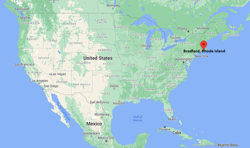
Bradford Map, Rhode Island, USA
Where is Bradford?: The Google Map showing the location of Bradford in the U.S. state of Rhode Island.
Where is Bradford Located?
Bradford is a village located in the Washington County of Rhode Island, United States. Bradford lies between 41.41145 Degrees North latitude and -71.7465 Degrees West longitude. According to the 2020 U.S. Census, the population of Bradford village is 1,657 people and the village has a total area of 1.833 sq mi. The village has numerous parks and recreational facilities.
Most Viewed US Maps
| USA Sttae Map | USA Region Map | USA Road Map |
| USA County Map | Where is USA in World Map? | US ZIP Code Map |
| USA Time Zones Map | US State and Capitals Map | USA Physical Map |
Find 4,400+ U.S. Cities by State - Explore Their Locations and Get Detailed Information
Bradford, Rhode Island Quick Facts
| Fact | Details |
|---|---|
| City | Bradford |
| County | Washington County |
| State | Rhode Island |
| State Capital | Providence |
| Country | United States |
| US Region | Northeast |
| Latitude | 41.41145 N |
| Longitude | -71.7465 W |
| Elevation | 39 ft (12 m) |
| Land Area | 1.833 sq mi |
| Water Area | 0.01 sq mi |
| Total Area | 1.833 sq mi |
| Population (Census 2020) | 1,457 |
| Population Density | Approximately 802 per sq mi |
| ZIP Code | 02808 |
| Area Code | 401 |
| Time Zone Standard | Eastern Standard Time (EST, UTC-5) |
| Time Zone Daylight | Eastern Daylight Time (EDT, UTC-4) |
| Currency | United States Dollar (USD) |
| FIPS Code | 44-08020 |
| Congressional District | Rhode Island's 2nd Congressional District |
Nearby Cities and Towns to Bradford, Rhode Island
- Westerly, Rhode Island - 4 mi South
- Hopkinton, Rhode Island - 5 mi North
- Stonington, Connecticut - 8 mi West
- Charlestown, Rhode Island - 9 mi East
- Richmond, Rhode Island - 10 mi Northeast
- North Stonington, Connecticut - 11 mi Northwest
- South Kingstown, Rhode Island - 14 mi East
- Wood River Junction, Rhode Island - 8 mi Northeast
- Watch Hill, Rhode Island - 8 mi South
- Wakefield, Rhode Island - 13 mi East
Driving Distances from Bradford, Rhode Island
| City | State | Distance (mi) | Approx. Drive Time |
|---|---|---|---|
| Westerly | Rhode Island | 4 | 10 min |
| Hopkinton | Rhode Island | 5 | 10 min |
| Stonington | Connecticut | 8 | 15 min |
| Charlestown | Rhode Island | 9 | 15 min |
| Richmond | Rhode Island | 10 | 15 min |
| North Stonington | Connecticut | 11 | 20 min |
| South Kingstown | Rhode Island | 14 | 25 min |
| Wakefield | Rhode Island | 13 | 25 min |
| New London | Connecticut | 20 | 30 min |
| Providence | Rhode Island | 45 | 50 min |
Transportation and Connectivity in Bradford, Rhode Island
| Transportation | Details |
|---|---|
| Nearest Airport | Westerly State Airport |
| Major Commercial Airport | T.F. Green International Airport |
| Major Highways | U.S. Route 1, Rhode Island Route 3 and Interstate 95 nearby |
| Rail Service | Amtrak service is available at Westerly and nearby stations |
| Local Transit | Rhode Island Public Transit Authority (RIPTA) serves the wider region |
- U.S. Route 1 provides an important north-south connection through southwestern Rhode Island and nearby coastal communities.
- Interstate 95 is accessible from Bradford and connects the area with Providence, Connecticut and other major cities along the Northeast.
- Westerly State Airport is the closest airport serving general aviation and private aircraft.
- T.F. Green International Airport near Warwick provides the area's main commercial air service.
- RIPTA provides public bus transportation across Rhode Island, with services concentrated in larger nearby communities.
Key Landmarks and Places to Visit in Bradford, Rhode Island
| Landmark | Type |
|---|---|
| Bradford Village Historic District | Historic District |
| Bradford Preserve | Nature Preserve |
| Grills Preserve | Nature Preserve |
| Westerly Library and Wilcox Park | Library and Public Park |
| Watch Hill Historic District | Historic Coastal Area |
| Napatree Point Conservation Area | Beach and Nature Area |
| Misquamicut State Beach | Beach and Recreation Area |
| Westerly Downtown Historic District | Historic District |
| Wilcox Park | Public Park |
| East Beach | Coastal Recreation Area |
Colleges and Universities Near Bradford, Rhode Island
| Institution | Type | Location | Notable For |
|---|---|---|---|
| University of Rhode Island | Public | Kingston, Rhode Island | Research, marine science, engineering and business |
| Connecticut College | Private | New London, Connecticut | Liberal arts and undergraduate education |
| Mitchell College | Private | New London, Connecticut | Career-focused undergraduate programs |
| Wesleyan University | Private | Middletown, Connecticut | Liberal arts and research |
| Rhode Island College | Public | Providence, Rhode Island | Education, nursing and liberal arts |
| Providence College | Private | Providence, Rhode Island | Liberal arts, business and sciences |
Waterbodies in and Around Bradford, Rhode Island
Westerly's Pawcatuck River, Pawcatuck River, Bradford Pond, Watchaug Pond, Quonochontaug Pond, Ninigret Pond, Winnapaug Pond, Atlantic Ocean, Block Island Sound and Little Narragansett Bay.
Golf Courses Near Bradford, Rhode Island
Westerly Country Club, Shelter Harbor Golf Club, Weekapaug Golf Club, Misquamicut Club, Richmond Country Club, Meadow Brook Golf Course, Shennecossett Golf Course and Norwich Golf Course.
Bradford, Rhode Island - Key Historical Facts
- Bradford is a historic village and census-designated place in Washington County, Rhode Island. The CDP is located within the town of Westerly.
- The Bradford Village Historic District includes historic buildings and sites that reflect the village's development from the eighteenth and nineteenth centuries.
- The district was listed on the National Register of Historic Places in 1996 and covers a large historic area with numerous contributing buildings.
- Bradford developed around local manufacturing, mills, agriculture and transportation routes that connected communities in southwestern Rhode Island.
- The village is located near Westerly and the Connecticut border, giving it close connections with communities in both Rhode Island and southeastern Connecticut.
- Today, Bradford is known for its historic character, nearby nature preserves, access to coastal recreation and convenient location in southwestern Rhode Island.
References
More Rhode Island Maps & Info
- Where is Ashaway
- Where is Bradford
- Where is Carolina
- Where is Central Falls
- Where is Chepachet
- Where is Cranston
- Where is Cumberland Hill
- Where is East Providence
- Where is Greene
- Where is Greenville
- Where is Harmony
- Where is Harrisville
- Where is Hope Valley
- Where is Kingston
- Where is Melville
- Where is Misquamicut
- Where is Narragansett Pier
- Where is Newport
- Where is Newport East
- Where is Pascoag
- Where is Pawtucket
- Where is Providence
- Where is Quonochontaug
- Where is Tiverton
- Where is Valley Falls
- Where is Warwick
- Where is Weekapaug
- Where is Westerly
- Where is Woonsocket
- Where is Wyoming