
Where is North Huntingdon, Pennsylvania Located in the United States? North Huntingdon is a city located in the Westmoreland County of Pennsylvania, United States. North Huntingdon lies between 40.3181 Degrees North latitudes and -79.7223 Degrees West longitudes.
Location Map of North Huntingdon in Westmoreland County, Pennsylvania
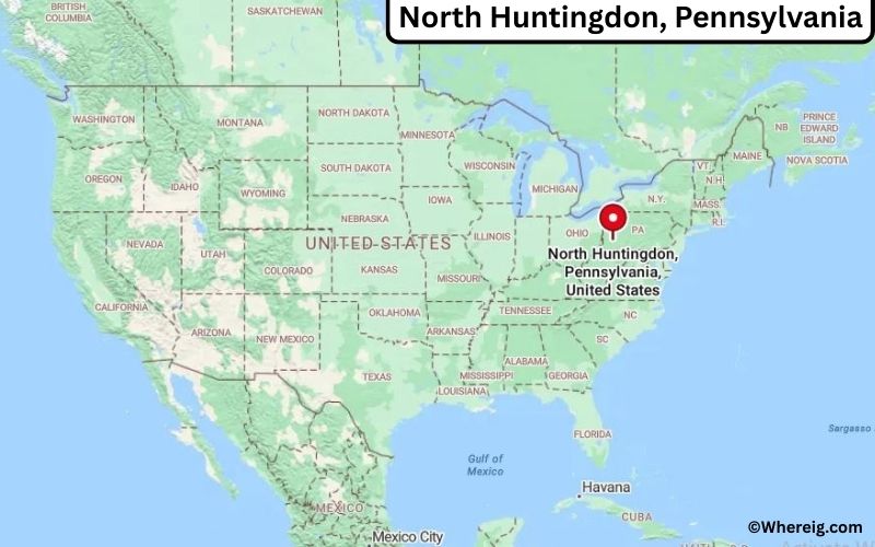
About Map: The map shows the location of North Huntingdon in the state of Pennsylvania, United States. North Huntingdon is a city in Westmoreland County, Pennsylvania.
North Huntingdon Map, Pennsylvania, USA
About North Huntingdon Map: This interactive Google Map shows the exact location of North Huntingdon in Pennsylvania, United States. You can zoom in or out, switch to satellite view, and explore nearby cities, roads, and local landmarks around North Huntingdon.
About North Huntingdon, Westmoreland County, Pennsylvania
North Huntingdon is a township located in Westmoreland County in the U.S. state of Pennsylvania, United States. Situated in southwestern Pennsylvania, the township lies southeast of Pittsburgh and is part of the Pittsburgh metropolitan area, serving as a residential and commercial community within Westmoreland County. North Huntingdon was established in 1772 and was named after Huntingdon, England. The township has developed into a suburban area with a mix of neighborhoods, businesses, and community facilities.
Population
According to the United States Census Bureau, the population of North Huntingdon is 30,915 as recorded in the 2020 Census, and the population density is approximately 1,000 people per square mile.
Geography
According to the United States Census Bureau, North Huntingdon covers a total area of approximately 30.9 square miles (about 80.03 square kilometers), including about 30.6 square miles (79.25 square kilometers) of land and about 0.3 square miles (0.78 square kilometers) of water.
Location and Surroundings
North Huntingdon is located in southwestern Pennsylvania within Westmoreland County, approximately 20 miles southeast of Pittsburgh. The surrounding region features suburban neighborhoods, commercial areas, and nearby rural landscapes that contribute to the township’s character.
Top Attractions in the City
North Huntingdon offers parks, recreational facilities, and community attractions for residents and visitors. Indian Lake Park provides walking trails, sports fields, and outdoor recreation opportunities, while local community centers and events support an active community life.
Transportation
North Huntingdon is served by major roadways including U.S. Route 30 and the Pennsylvania Turnpike (Interstate 76), providing convenient access to Pittsburgh and surrounding regions. The nearest major airport serving the area is Pittsburgh International Airport, located about 35 miles northwest of the township.
Explore more cities and counties across Pennsylvania or view the complete USA States Map for additional geographic information.
Sources:
Population and area data sourced from the United States Census Bureau (2020 Census). General information referenced from the Official North Huntingdon Township Website.
Most Viewed US Maps
| USA Sttae Map | USA Region Map | USA Road Map |
| USA County Map | Where is USA in World Map? | US ZIP Code Map |
| USA Time Zones Map | US State and Capitals Map | USA Physical Map |
Find 4,400+ U.S. Cities by State - Explore Their Locations and Get Detailed Information
North Huntingdon, Pennsylvania Quick Facts
| Attribute | Information |
|---|---|
| City | North Huntingdon Township |
| County | Westmoreland County |
| State | Pennsylvania |
| State Capital | Harrisburg |
| US Region | Northeast (Middle Atlantic) |
| Latitude | 40.3284° N |
| Longitude | 79.7198° W |
| Elevation | 1,070 ft (326 m) |
| Land Area | 27.41 sq mi |
| Water Area | 0.05 sq mi |
| Total Area | 27.46 sq mi |
| Population (2020 Census) | 31,880 |
| Population Density | Approximately 1,163 per sq mi |
| ZIP Codes | 15642, 15644 |
| Area Code | 724 |
| Time Zone Standard | Eastern Standard Time (EST, UTC−5) |
| Time Zone Daylight | Eastern Daylight Time (EDT, UTC−4) |
| Currency | United States Dollar (USD) |
| FIPS Code | 42-53392 |
| Congressional District | Pennsylvania's 14th Congressional District |
Transportation and Connectivity in North Huntingdon
| Category | Information |
|---|---|
| Airport Name | Pittsburgh International Airport |
| IATA Code | PIT |
| Nearest Regional Airport | Arnold Palmer Regional Airport |
| Major Highways | U.S. Route 30, Interstate 76 (Pennsylvania Turnpike), Interstate 70 nearby |
| Rail Service | Freight rail service available in Westmoreland County |
| Public Transit | Westmoreland Transit services |
| Regional Connections | Pittsburgh metropolitan area and Westmoreland County access |
- North Huntingdon is a township located in Westmoreland County, Pennsylvania, southeast of Pittsburgh.
- The township is positioned between Pittsburgh and Greensburg, providing access to major regional employment centers.
- U.S. Route 30 and nearby Pennsylvania Turnpike connections provide important transportation links.
- North Huntingdon was established in 1773 and has developed from an agricultural community into a suburban township. :contentReference[oaicite:1]{index=1}
Top Places to Visit in North Huntingdon, Pennsylvania
| Landmark Name | Type |
|---|---|
| Oak Hollow Park | Community Park |
| Braddock's Trail Park | Trail and Recreation Area |
| Indian Lake Park | Park and Outdoor Recreation Area |
| Big Mac Museum | Food and History Museum |
| Irwin Historic District | Historic Area |
| Westmoreland County Historical Sites | Historic Attractions |
| Idlewild & SoakZone | Theme and Water Park |
| Historic Hanna's Town | Open-Air Museum |
| The Westmoreland Museum of American Art | Art Museum |
| Laurel Highlands Region | Outdoor Recreation Area |
Driving Distances from North Huntingdon, Pennsylvania to Nearby Cities
| City | State | Distance (mi) | Approx. Drive Time |
|---|---|---|---|
| Irwin | Pennsylvania | 3 | 10 minutes |
| Greensburg | Pennsylvania | 12 | 20 minutes |
| Pittsburgh | Pennsylvania | 25 | 35 minutes |
| Monroeville | Pennsylvania | 18 | 25 minutes |
| Latrobe | Pennsylvania | 25 | 35 minutes |
| Washington | Pennsylvania | 55 | 1 hour |
| Johnstown | Pennsylvania | 55 | 1 hour 15 minutes |
| Morgantown | West Virginia | 70 | 1 hour 20 minutes |
| Harrisburg | Pennsylvania | 220 | 3 hours 30 minutes |
| Philadelphia | Pennsylvania | 300 | 4 hours 45 minutes |
Colleges and Universities Near North Huntingdon, Pennsylvania
| Institution Name | Type | Level | Notable For |
|---|---|---|---|
| University of Pittsburgh at Greensburg | Public | University | Liberal arts, business, sciences, and undergraduate education |
| Seton Hill University | Private | University | Education, health sciences, business, and arts |
| Westmoreland County Community College | Public | Community College | Technical education, workforce training, and associate degrees |
| Saint Vincent College | Private | College | Liberal arts, business, sciences, and theology |
| University of Pittsburgh | Public | University | Research, medicine, engineering, and professional programs |
Waterbodies Near North Huntingdon, Pennsylvania
Brush Creek, Sewickley Creek, Youghiogheny River, Loyalhanna Creek, and nearby waterways of Westmoreland County.
Stadiums and Sports Facilities in North Huntingdon
North Huntingdon Township recreational facilities, Norwin High School athletic facilities, Oak Hollow Park sports areas, and nearby Westmoreland County sports venues.
North Huntingdon, Pennsylvania — Key Historical Facts
- North Huntingdon Township was established in 1773 and was named after Huntingdon County, Pennsylvania.
- The area developed from early agricultural settlements into a suburban community connected to Pittsburgh and the surrounding region.
- The township played a role in the region's early transportation history with roads connecting eastern settlements to western Pennsylvania.
- Industrial development in nearby communities, including coal mining and manufacturing, influenced regional growth.
- The area preserves historic landmarks connected to the colonial and early American periods.
- Today, North Huntingdon is recognized as a suburban township with parks, historic sites, schools, and convenient access to the Pittsburgh metropolitan area.
References
- North Huntingdon Township
- Westmoreland County Government
- U.S. Census Bureau
- Pennsylvania Tourism
- National Park Service
Pennsylvania More Maps & Info
- Where is Abington
- Where is Bensalem
- Where is Bristol
- Where is Buckingham
- Where is Cheltenham
- Where is Coolbaugh
- Where is Cranberry
- Where is Derry
- Where is Dover
- Where is East Hempfield
- Where is East Pennsboro
- Where is Exeter
- Where is Falls
- Where is Hampden
- Where is Haverford
- Where is Hempfield
- Where is Lower Macungie
- Where is Lower Makefield
- Where is Lower Merion
- Where is Lower Paxton
- Where is Lower Providence
- Where is Manheim
- Where is Marple
- Where is McCandless
- Where is Middletown
- Where is Millcreek
- Where is Montgomery
- Where is Moon
- Where is Mount Lebanon
- Where is North Huntingdon
- Where is Northampton
- Where is Palmer
- Where is Penn Hills
- Where is Peters
- Where is Pottstown
- Where is Radnor
- Where is Ridley
- Where is Ross
- Where is Shaler
- Where is Spring
- Where is Springettsbury
- Where is Springfield
- Where is Susquehanna
- Where is Swatara
- Where is Tredyffrin
- Where is Unity
- Where is Upper Darby
- Where is Upper Dublin
- Where is Upper Macungie
- Where is Upper Merion
- Where is Upper Moreland
- Where is Upper Providence
- Where is Warminster
- Where is Warrington
- Where is West Goshen